- Arizona State Route 386
Infobox road
marker_
state=AZ
highway_name=
name_notes=
type=state
route=386
alternate_name=
maint=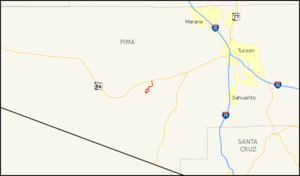
length_mi=11.88
length_round=2
length_ref=cite web |url=http://tpd.az.gov/data/reports/2006SHSLog.pdf |title=2006 ADOT Highway Log |author=Arizona Department of Transportation |accessdate=2008-04-08]
length_notes=
established=
decommissioned=
direction_a=South
starting_terminus=NearKitt Peak National Observatory
junction=
direction_b=North
ending_terminus=jct|state=AZ|SR|86
previous_type=AZ
previous_route=377
next_type=AZ
next_route=387
commons=State Route 386, also known as SR 386, is a state highway in southern
Arizona entirely within the Tohono O'odham Nation, traveling from State Route 86 toKitt Peak National Observatory .Route description
SR 386 is a convert|11.88|mi|km|sing=on highway that connects the
Kitt Peak National Observatory with SR 86. The southern terminus of the highway is located at the observatory. The highway leaves the observatory heading towards the southwest as it descends the mountain. It eventually begins to make the turn towards the west, then the north, and finally the northeast. The highway follows the terrain of the mountain and does not follow a direct route to SR 86. The highway makes a turn towards the north once the terrain smooths out as it heads towards its northern terminus at SR 86. [cite map|publisher=Google Maps |title=Overview map of SR 386|accessdate=2008-04-10|url=http://maps.google.com/maps?f=d&hl=en&geocode=18048916757791373617,32.026900,-111.577450%3B6879537675053160389,31.970058,-111.613213%3B84559984016019476,31.963021,-111.599888&saddr=S+Kitt+Peak+Rd+%4032.026900,+-111.577450&daddr=S+Kitt+Peak+Rd+%4031.970058,+-111.613213+to:S+Kitt+Peak+Rd+%4031.963021,+-111.599888&via=1&doflg=ptm&sll=31.98665,-111.599245&sspn=0.15317,0.374908&ie=UTF8&z=12]Junction list
The entire route is in
Tohono O'odham Indian Reservation , Pima County.References
External links
* [http://arizonaroads.com/arizona/az386.html SR 386 at Arizona Roads]

Wikimedia Foundation. 2010.