Myers Park, Auckland

Myers Park, Auckland
Myers Free Kindergarten building in Myers Park.
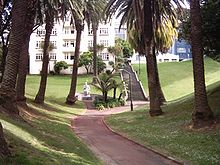
The palm-lined main path, upper part of the park.

Myers Park is a narrow park in central Auckland, New Zealand, running parallel to the upper part of Queen Street. It is characterised by steep, grassed slopes and canopied with a mixture of large exotic and native trees, including an alley of large palm trees. Benches and artwork (including a heritage marble copy of Michelangelo's sitting Moses statue) line the paths connecting to Queen Street, K Road, Grey's Avenue and Aotea Square.

History

Running downhill from the northern slope of the Karangahape ridge, the park was formed in 1914 out of an overgrown gully facing towards the Waitemata Harbour. The gully was the start of the Waihorotiu Stream, also known as the 'Queen Street River', temporarily used as an open sewer, now underground. Around 1914, the area of the gully was described as consisting of "slum shanties and rubbish tips", until a former Mayor of Auckland Arthur Mielzinier Myers donated £9,000 to the city to buy the area and transform 2.4 ha of the wasteland into Myers Park.[1]

In 1915 Myers also funded the construction of the Myers Free Kindergarten, a fine example of Arts & Crafts architecture (Chilwell & Trevithick Architects). The kindergarten, like a similar gift of other philanthropists in Victoria Park, was intended to benefit the mostly poor families of the area.[2] The building still holds a kindergarten today (KiNZ in the Park) and is, together with parts of the park itself, on the register of the Historic Places Trust.[3]

The park also contains the caretaker's cottage, one of only two Kauri buildings on Queen Street that are more than 100 years old.[4]

References

  1. ^ Myer's gift to the city (from City Scene, Sunday 29 October, 2006)
  2. ^ KiNZ Background (from the Kindergarten New Zealand, KiNZ website)
  3. ^ "Myers Park Historic Area". Register of Historic Places. New Zealand Historic Places Trust. http://www.historic.org.nz/TheRegister/RegisterSearch/RegisterResults.aspx?RID=7008&m=advanced. Retrieved 2009-12-21. 
  4. ^ Watson, John (9 October 2008). "Century-old kauri building in way of Q Theatre". The New Zealand Herald. http://www.nzherald.co.nz/nz/news/article.cfm?c_id=1&objectid=10536536. Retrieved 27 October 2011. 

Coordinates: 36°51′19″S 174°45′40″E / 36.8553641°S 174.7612166°E / -36.8553641; 174.7612166


Wikimedia Foundation. 2010.

Игры ⚽ Нужно сделать НИР?

Look at other dictionaries:

  • Myers Park — may refer to: Myers Park, Auckland, New Zealand Myers Park, Charlotte, North Carolina Myers Park, Collin County, Texas This disambiguation page lists articles about distinct geographical locations with the same name. If an …   Wikipedia

  • Victoria Park, Auckland — Victoria Park is a park and sports ground in Auckland City, New Zealand. It lies on reclaimed bay land in Freemans Bay, a suburb directly west of the Auckland CBD. This origin of the land makes it very flat and level. However, it does not have… …   Wikipedia

  • Auckland — Saltar a navegación, búsqueda Para otros usos de este término, véase Auckland (desambiguación). Auckland …   Wikipedia Español

  • Auckland City — Auckland 36° 51′ 00″ S 174° 47′ 00″ E / 36.85, 174.7833 …   Wikipédia en Français

  • MYERS, SIR ARTHUR MELZINER — (1867–1926), New Zealand businessman and politician. Myers came from a family of German immigrants who opened a brewery in New Zealand. His father, who became a jewelry salesman, drowned in 1870 and Myers was raised by an uncle in Wellington,… …   Encyclopedia of Judaism

  • Auckland — This article is about the Auckland metropolitan area. For the wider region, see Auckland Region. For the local authority, see Auckland Council. For all other uses, see Auckland (disambiguation). Auckland Tāmaki Makaurau (Māori)   Main… …   Wikipedia

  • Auckland — Pour les articles homonymes, voir Îles Auckland.  Ne doit pas être confondu avec Oakland …   Wikipédia en Français

  • District d'Auckland — Auckland 36° 51′ 00″ S 174° 47′ 00″ E / 36.85, 174.7833 …   Wikipédia en Français

  • Queen Street, Auckland — Queen Street is the major commercial thoroughfare of the Auckland CBD in Auckland City, New Zealand s main population centre. It rises from Queens Wharf on the Auckland waterfront, adjacent to the Britomart Transport Centre and the Downtown Ferry …   Wikipedia

  • Arthur Myers — Sir Arthur Mielziner Myers (19 May 1868 – 9 October 1926) was a New Zealand politician. He was Mayor of Auckland from 1905 to 1909, Member of the House of Representatives from 1910 to 1921, and a Cabinet Minister. Today he is remembered mainly… …   Wikipedia

Share the article and excerpts

Direct link
Do a right-click on the link above
and select “Copy Link”