- Oyster Bay (hamlet), New York
-
This article is about the unincorporated hamlet. For the town encompassing the hamlet, see Town of Oyster Bay, New York.
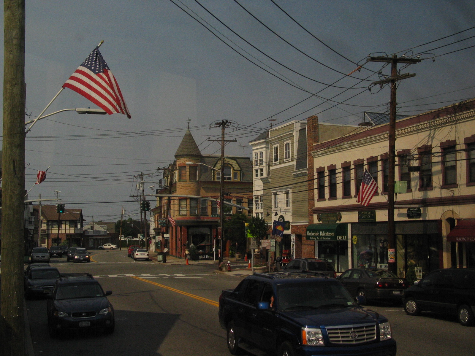
Oyster Bay, New York — Village — Downtown Oyster Bay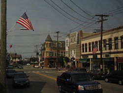

 Oyster Bay, New York
Coordinates: 40°45′34″N 73°30′10″W / 40.75944°N 73.50278°WCoordinates: 40°45′34″N 73°30′10″W / 40.75944°N 73.50278°W Country United States State New York County Nassau Area – Total 1.6 sq mi (4.2 km2) – Land 1.2 sq mi (3.2 km2) – Water 0.4 sq mi (1.0 km2) Elevation 180 ft (55 m) Population (2010) – Total 6,707 Time zone Eastern (EST) (UTC-5) – Summer (DST) EDT (UTC-4) ZIP code 11771 Area code(s) 516 FIPS code GNIS feature ID  Typical landscapes of Oyster Bay
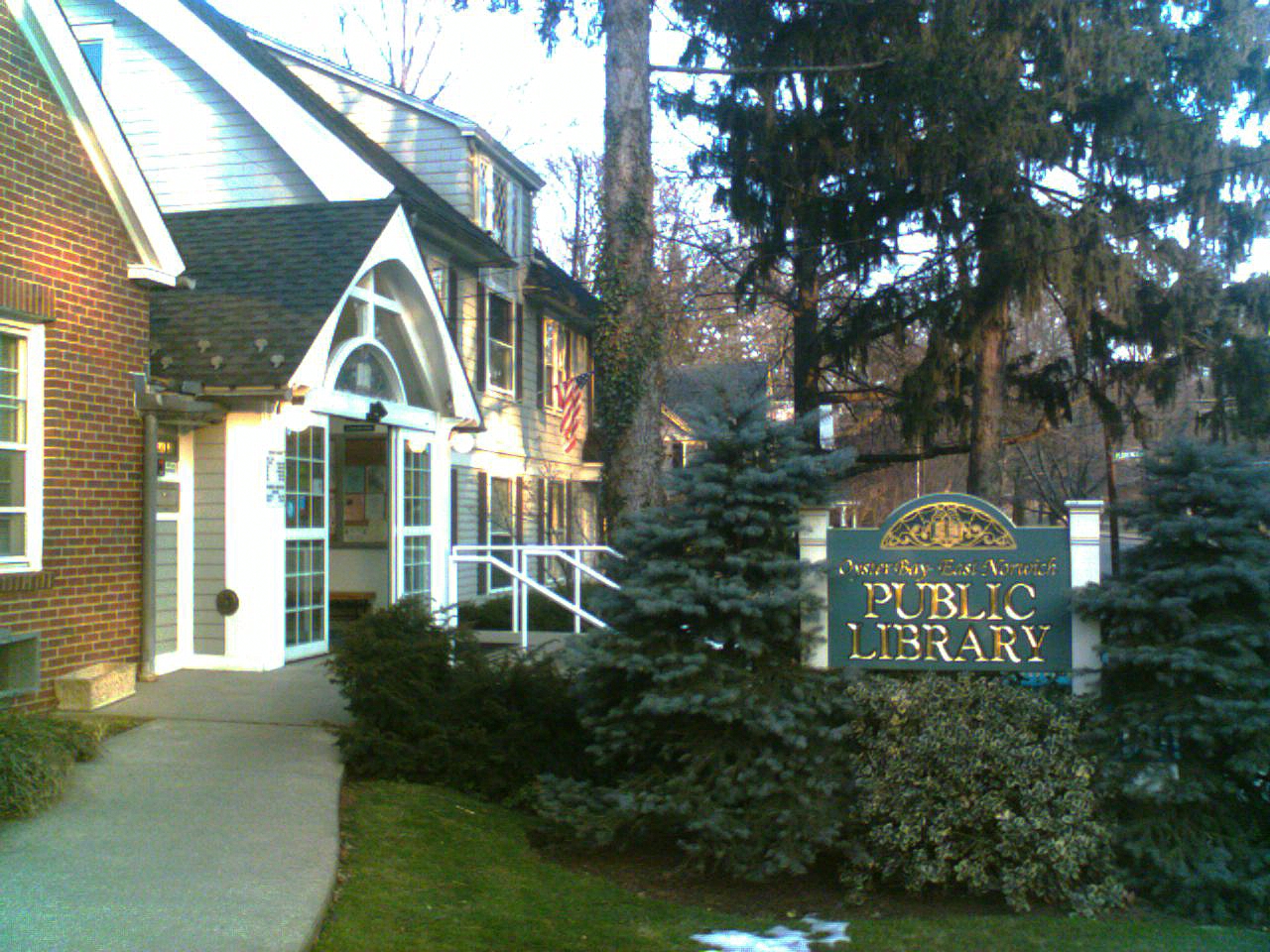
 Oyster Bay - East Norwich Public Library
Oyster Bay is the name of a hamlet and census-designated place on the North Shore of Long Island in Nassau County in the state of New York, United States. The hamlet is also the site of a station on the Oyster Bay Branch of the Long Island Rail Road and the eastern termination point of that branch of the railroad.
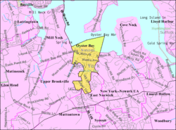
The community is within the Town of Oyster Bay, New York, a town which contains 18 villages and 18 hamlets.
The hamlet's area was considerably larger before several of its parts incorporated as separate villages. At least six of the 36 villages and hamlets of the Town of Oyster Bay have shores on Oyster Bay Harbor and its inlets, and many of these were previously considered part of the hamlet of Oyster Bay; three of those are now known as Mill Neck, Bayville & Centre Island. The Oyster Bay Post Office (ZIP code 11771) serves several of the surrounding areas also, including the villages Oyster Bay Cove, Cove Neck, and Upper Brookville.
The Oyster Bay-East Norwich Central School District was created on July 1, 1960, by the action of the voters in the former Oyster Bay and East Norwich School Districts. The district's 13.1 square miles (34 km2) boundaries include the hamlets of Oyster Bay and East Norwich and the incorporated villages of Centre Island, Oyster Bay Cove, Cove Neck, and portions of Mill Neck, Muttontown, Laurel Hollow, and Upper Brookville. There are three schools currently in the district: Roosevelt Elementary School (Grades K-2), James H. Vernon Middle School (Grades 3-6), and Oyster Bay High School (Grades 7-12).
The population of the CDP of Oyster Bay as of the 2010 Census was at 6,707.
Contents
History
The first mention of Oyster Bay comes from Captain David Peterson de Vries, who in his Journal recalls how on June 4, 1639, he "came to anchor in Oyster Bay, which is a large bay which lies on the north side of the Great Island… There are fine oysters here, whence our nation has given it the name of Oyster Bay."
Oyster Bay was settled by the Dutch, and was the boundary between the Dutch New Amsterdam colony and the English New England Colonies. The English, under Peter Wright, first settled in the area in 1653. The boundary between the Dutch and English was somewhat fluid which led to each group having their own Main Street.
Many Quakers came to Oyster Bay, escaping persecution from Dutch authorities in New Amsterdam. These included Elizabeth Feake and her husband Captain John Underhill who she converted to Quakerism. Other notable Quakers to settle in Oyster Bay were the brothers John Townsend and Henry Townsend. Noted dissenter and Quaker George Fox visited Oyster Bay in 1672, where he spoke with the Wrights, Underhill and Feake at a Quaker gathering on the site of Council Rock, facing the Mill Pond.[1]
During the Revolutionary War, Raynham Hall was owned by the patriot Townsend family. For a six-month period from 1778 to 1779, the Townsend home served as British headquarters for the Queen's Rangers led by Lt. Col. John Graves Simcoe. Simcoe was often visited by British officer Major John Andre. According to legend, on one of these visits Samuel's[who?] daughter Sally Townsend overheard the two officers discussing Benedict Arnold's traitorous plot to surrender the fort at West Point to the British.[clarification needed]
In the 1880s, the LIRR extended rail service from Locust Valley as a means to establish a connection between New York and Boston, via steamboat on the Long Island Sound. On June 21, 1889, the first LIRR train arrived in Oyster Bay. In the following year, service commenced with the train coaches being loaded onto a ferry for a connection to the New Haven Railroad at Norwalk, CT. Service lasted less than a year.[2]
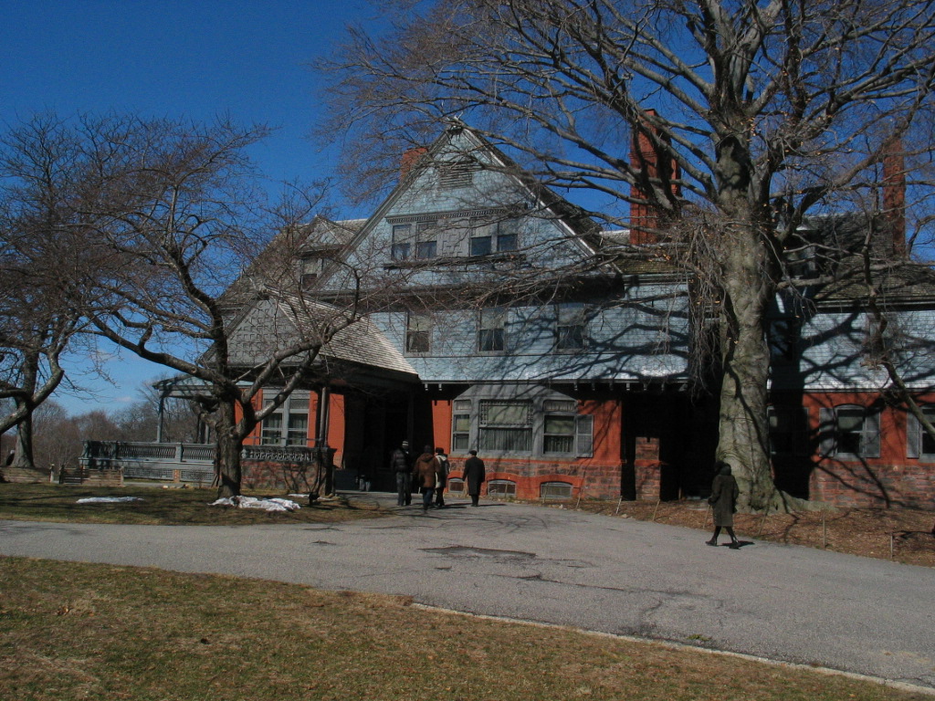
Around the time railroad service was introduced Theodore Roosevelt, the future 26th President of the United States, chose to make his home at Sagamore Hill, in present day Cove Neck, a neighboring incorporated village (Cove Neck was not incorporated until 1927). Sagamore Hill was completed in 1886. This is where Roosevelt lived until his death in 1919. His wife Edith Roosevelt continued to occupy the house until her death, nearly three decades later, in September 1948. On July 25, 1962, Congress established the Sagamore Hill National Historic Site to preserve the house.
Efforts to honor Theodore Roosevelt in Oyster Bay have greatly improved the hamlet. These include design of the Theodore Roosevelt Memorial Park. This beautiful waterfront park gives residents and visitors alike access to the pristine and beautiful Oyster Bay Harbor. Other Roosevelt-related landmarks have been restored including Snouder's Drug Store - location of the first telegraph in Oyster Bay, Moore's Building - today the popular Wild Honey restaurant, and proposals to restore the Oyster Bay Long Island Rail Road Station - home station of TR and the Octagon Hotel - built in 1851 and once home to offices of Governor Roosevelt. A local non-profit, the Oyster Bay Main Street Association, developed an audio tour of these historic sites and many others called the Oyster Bay History Walk.
The oysters that give the bay its name are now the only source of traditionally farmed oysters from Long Island, providing up to 90% of all the oysters harvested in New York State.
Geography
Oyster Bay is located at 40°52′1″N 73°31′55″W / 40.86694°N 73.53194°W (40.867105, -73.532038).[3]
According to the United States Census Bureau, the CDP has a total area of 1.6 square miles (4.1 km2), of which, 1.2 square miles (3.1 km2) of it is land and 0.4 square miles (1.0 km2) of it (23.60%) is water.
For the 2000 census, the CDP was enlarged beyond the boundaries used for the 1990 census.[4]
Demographics
As of the census[5] of 2000, there were 6,826 people, 2,815 households, and 1,731 families residing in the area. The population density was 5,554.1 per square mile (2,142.7/km²). There were 2,898 housing units at an average density of 2,358.0/sq mi (909.7/km²). The racial makeup of the community was 90.51% White, 3.16% Black or African American, 0.28% Native American, 1.76% Asian, 0.03% Pacific Islander, 2.17% from other races, and 2.09% from two or more races. Hispanic or Latino of any race were 12.25% of the population.
There were 2,815 households out of which 26.0% had children under the age of 18 living with them, 48.3% were married couples living together, 9.7% had a female householder with no husband present, and 38.5% were non-families. 33.1% of all households were made up of individuals and 13.4% had someone living alone who was 65 years of age or older. The average household size was 2.39 and the average family size was 3.06.
In the area the population was spread out with 20.7% under the age of 18, 6.4% from 18 to 24, 32.3% from 25 to 44, 23.8% from 45 to 64, and 16.8% who were 65 years of age or older. The median age was 40 years. For every 100 females there were 92.3 males. For every 100 females age 18 and over, there were 89.3 males.
The median income for a household in the area was $57,993, and the median income for a family was $73,500. Males had a median income of $51,968 versus $41,926 for females. The per capita income for the area was $34,730. About 3.3% of families and 7.8% of the population were below the poverty line, including 5.5% of those under age 18 and 12.1% of those age 65 or over.
Notable past residents
 Sagamore Hill
Oyster Bay is known for the residence and summer White House of Theodore Roosevelt, Sagamore Hill (though that residence is in a nearby area known since 1927 as the Village of Cove Neck).
Many well-known American celebrities spent their youth in this area; among its better known former residents are musician Billy Joel, tennis players John McEnroe and his brother Patrick, actress Heather Matarazzo, William Woodward Originator of Cinorama, authors Thomas Pynchon and Tracy Kidder, basketball coach Rick Pitino of Bayville, who attended St. Dominic's School here, and Sonic Youth guitarist Lee Ranaldo (Matarazzo, Pynchon and Ranaldo attended Oyster Bay High School). A less distinguished figure from the hamlet's past is Typhoid Mary, whose contagiousness was discovered following an investigation into her employment at a summer home in Oyster Bay in 1906. Composer John Barry lived in Oyster Bay until his death in 2011.
It was also the setting of the 2000 movie Meet the Parents.
Points of interest
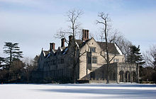 Photo of Coe Hall by Robert Swanson
- Theodore Roosevelt (26th President of the United States) is buried in Oyster Bay at Youngs Memorial Cemetery.
- Planting Fields Arboretum, a 400 acres (1.6 km2) arboretum and botanical garden including Coe Hall near Oyster Bay.
- Sagamore Hill National Historic Site, is the historic home of Theodore Roosevelt, who was the 26th President of the United States.
- Raynham Hall Museum, home of the Samuel Townsend family and a British headquarters during the American Revolution. Townshend's son, Robert, was a member of the Culper Spy Ring.
- The WaterFront Center a non-profit center for marine education and recreation offering sailing lessongs and environmental education programs. It also owns the Sloop Christeen which it uses for sails around the harbor.
- Matinecock Lodge Temple and Matinecock Historical Society Building on West Main Street. Theodore Roosevelt and Quentin Roosevelt II were both members of Matinecock Lodge, No. 806. The original Lodge building burned down in October 2003 and has since been re-built through the efforts of the members of the Lodge and the citizens of Oyster Bay and the surrounding community.
- Beekman Beach
- Sagamore Rowing Association
Education
Oyster Bay is served by the Oyster Bay-East Norwich Central School District. Schools in the OBEN CSD include:
- Oyster Bay High School, within the hamlet, is the sole public high school.
- James H. Vernon School
- Theodore Roosevelt Elementary School
There are several private schools in close proximity to Oyster Bay. These include:
Economy
Acclaim Entertainment was originally located in the hamlet of Oyster Bay.[6] It originally occupied a one-room office in Oyster Bay. At a later time it occupied a brick structure with two stories.[7] In 1994 Acclaim bought a headquarters building in Glen Cove.[8]
See also
- Oyster Bay History Walk
- Theodore Roosevelt in Oyster Bay
- List of Town of Oyster Bay Landmarks
- National Register of Historic Places listings in Nassau County, New York
References
- ^ New York State Education Department historic marker, dedicated 1939
- ^ For pictures, see http://arrts-arrchives.com/obay3.html
- ^ "US Gazetteer files: 2010, 2000, and 1990". United States Census Bureau. 2011-02-12. http://www.census.gov/geo/www/gazetteer/gazette.html. Retrieved 2011-04-23.
- ^ "New York: 2000 Population and Housing Unit Counts". September 2003. p. III-9. http://www.census.gov/prod/cen2000/phc-3-34.pdf. Retrieved 2010-12-22.
- ^ "American FactFinder". United States Census Bureau. http://factfinder.census.gov. Retrieved 2008-01-31.
- ^ Standard and Poor's Register of Corporations, Directors and Executives, Volume 1. Standard & Poor's, 1995. Page listing Acclaim. Retrieved from Google Books on July 8, 2010. "ACCLAIM ENTERTAINMENT INC. (See Corporate Information Section) 71 Audrey Ave., Oyster Bay, NY 11771"
- ^ Pederson, James P. International Directory of Company Histories, Volume 24. St. James Press, 1998. Approx. Pages 3-7-ish. Retrieved from Google Books on July 8, 2010. ISBN 1558623655, 9781558623651 "Acclaim went from a shoestring budget and one-room office in Oyster Bay, to a two-story brick structure,"
- ^ "Acclaim buys Glen Cove site." Real Estate Weekly. July 20, 1994. Retrieved on July 8, 2010.
External links
- Oyster Bay Historical Society
- Oyster Bay Main Street Association
- Oyster Bay - East Norwich Central School District
- Enterprise Pilot - Local Oyster Bay Newspaper
- Pictures of Oyster Bay's Historic Estates & Homes
Town of Oyster Bay, New York County Villages Hamlets Bethpage · East Massapequa · East Norwich · Glen Head · Glenwood Landing · Greenvale · Hicksville · Jericho · Locust Valley · Massapequa · North Massapequa · Old Bethpage · Oyster Bay · Plainedge · Plainview · South Farmingdale · Syosset · Woodbury
Website: oysterbaytown.comCategories:- Census-designated places in New York
- Hamlets in New York
- Town of Oyster Bay, New York
- Populated places in Nassau County, New York


Wikimedia Foundation. 2010.