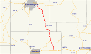
Indiana State Road 46 — Infobox road marker state=IN highway name= name notes= type=IN route=46 alternate name= section= length mi=153.7 length round=1 length ref= [http://illi indi.com/EndsPage.php?id=1046 section=1 Indiana Highway Ends SR 46] ] length notes=… … Wikipedia
Indiana State Road 445 — Infobox road state=IN type=IN route=445 alternate name= length mi=1.4 length round=1 length ref= [http://illi indi.com/EndsPage.php?id=1445 section=1 Indiana Highway Ends SR 445] ] established= direction a=East starting terminus= junction=… … Wikipedia
Indiana State Road 450 — Infobox road state=IN type=IN route=450 alternate name= length mi=26.4 length round=1 length ref= [http://illi indi.com/EndsPage.php?id=1450 section=1 Indiana Highway Ends SR 450] ] established= counties=Martin, Lawrence direction a=West starting … Wikipedia
Monroe County, Indiana — Monroe County courthouse in Bloomington, Indiana … Wikipedia
List of State Roads in Indiana — State Roads in the US state of Indiana are numbered rationally: in general, odd one digit and two digit highways are north south highways, numbers increasing toward the west; even one digit and two digit highways are east west highways, numbers… … Wikipedia
Patoka Township, Gibson County, Indiana — Infobox Settlement official name = Patoka Township settlement type = Township nickname = motto = imagesize = image caption = image mapsize = map caption = Location of Patoka Township within Gibson County mapsize1 = map caption1 = subdivision type … Wikipedia
State highways in New Jersey — Standard route signage in New Jersey Highway names Interstates: Interstate X (I X) … Wikipedia
State highways in Colorado — The standard Colorado state highway sign. The top half is the flag of Colorado. Highway names Interstates: Interstate X (I X) US Routes: U.S. Highway X (US X) … Wikipedia
Bedford, Indiana — Infobox Settlement official name = City of Bedford, Indiana settlement type = City nickname = Bloomfield imagesize = image caption = image imagesize = image caption = image mapsize = 250x200px map caption = Location in the state of Indiana… … Wikipedia
Fremont, Indiana — Infobox Settlement official name = Town of Fremont, Indiana settlement type = Town nickname = mapsize = 250x200px imagesize = image caption = imagesize = image caption = map caption = Location in the state of Indiana mapsize1 = map caption1 =… … Wikipedia