Weeting Castle

Weeting Castle

Geobox|Castle
name = Weeting Castle
category =Fortified manor house


image_caption =Weeting Castle


symbol = Standard of the English Heritage.svg
country = England
state = Norfolk
region = East of England
district = Breckland
municipality = Weeting
location =
elevation =
prominence =
lat_d =
lat_m =
lat_s =
lat_NS =
long_d =
long_m =
long_s =
long_EW =
length =
length_orientation =
width =
width_orientation =
height =
depth =
volume =
area =
author =
style = Norman architecture
material =Mortatred flint rubble with stone dressings
established =c1130's
date =
owner = Managed by English Heritage
public =
visitation = Located 2 miles N of Brandon off B1106
visitation_date =All year
Any reasonable time
Monday to Sunday
access =
free = | free_type =


map_caption =
map_background =
map_locator =
map_locator_x =
map_locator_y =
website =http://www.english-heritage.org.uk/server/show/nav.12532
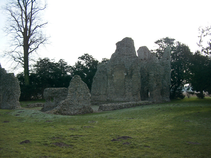
footnotes =

Weeting Castle is a 12th century ruin with a three story high tower in Weeting, Norfolk, near Brandon. Despite the name, it is not a castle but actually a fortified manor house. It has a large open hall and an attached two-storey chamber block. There's a domed brick ice-house on the northwest corner of the moat and a small car park next to the church. The moat was added in the 14th century. The place is thought to be abandoned in 1390. It is now owned by English Heritage. Entry is free and the location is open all year for visitors.

ee also

*Castles in England


Wikimedia Foundation. 2010.

Игры ⚽ Поможем сделать НИР

Look at other dictionaries:

  • Weeting — is a village in Norfolk, England. Its church, St. Mary, stands close to Weeting Castle, and is one of 124 existing round tower churches in Norfolk.During the 1920s and 1930s, Weeting housed a Ministry of Labour work camp. Basing its operations in …   Wikipedia

  • Newton by Castle Acre — Coordinates: 52°42′21″N 0°42′33″E / 52.7058°N 0.70918°E / 52.7058; 0.70918 …   Wikipedia

  • Liste des propriétés de l'English Heritage — Cette page liste les propriétés de l’English Heritage, l’organisme public indépendant chargé de la gestion du patrimoine historique en Angleterre. Elle les classe selon les régions anglaises, puis selon les comtés cérémoniaux. Sommaire 1… …   Wikipédia en Français

  • Список замков Англии — …   Википедия

  • List of English Heritage properties — English Heritage Properties in England is a link page for any stately home, historic house, castle, abbey, museum or other property in the care of English Heritage.Bedfordshire*Bushmead Priory *De Grey Mausoleum *Houghton House *Wrest Park… …   Wikipedia

  • Mileham — Coordinates: 52°44′15″N 0°50′02″E / 52.73751°N 0.83397°E / 52.73751; 0.83397 …   Wikipedia

  • 15th century in Wales — This article is about the particular significance of the century 1400 1499 to Wales and its people. Princes of Wales*Henry of Monmouth (later King Henry V) (to 1413) *Owain Glyndŵr (unofficially, 1400 1415) *Edward of Westminster (1454 1471)… …   Wikipedia

  • William de Warenne, 1st Earl of Surrey — William de Warenne, 1st Earl of Surrey, (died 1088) was one of the Norman nobles who fought at the Battle of Hastings and became great landowners in England.He was a son of Rodulf II de Warenne and Emma and a grandnephew of duchess Gunnor, wife… …   Wikipedia

  • Mundford — Coordinates: 52°30′30″N 0°39′21″E / 52.508281°N 0.655746°E / 52.508281; 0.655746 …   Wikipedia

  • List of Nature Conservation Review sites — The following is a list of sites listed in Derek Ratcliffe s 1979 book A Nature Conservation Review . The headings, subheadings, site codes and site names are the same as those used in the original work.Coastlandsoutheast Englandouth west… …   Wikipedia

Share the article and excerpts

Direct link
Do a right-click on the link above
and select “Copy Link”