Kalverdijk — 52° 44′ 00″ N 4° 46′ 00″ E / 52.7333, 4.76667 … Wikipédia en Français
Kalverdijk (homonymie) — Cette page d’homonymie répertorie les différents sujets et articles partageant un même nom. Toponyme Pays Bas Kalverdijk, village de la commune de Harenkarspel … Wikipédia en Français
Internationale Friedensfahrt 1967 — Die 20. Internationale Friedensfahrt (Course de la paix) fand vom 10. – 25. Mai 1967 statt. Die 20. Auflage des Radrennens bestand aus 16 Einzeletappen und führte auf einer Gesamtlänge von 2307 km von Warschau über Ost Berlin nach Prag.… … Deutsch Wikipedia
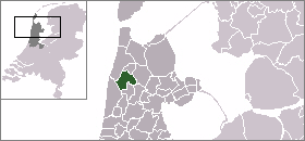
Harenkarspel — Infobox Settlement official name = Harenkarspel mapsize = 280px flag size = 150x75px image shield = Harenkarspel wapen.png shield size = 150x75px subdivision type = Country subdivision name = Netherlands subdivision type1 = Province subdivision… … Wikipedia
List of places in the Netherlands — This is an alphabetical list of places (cities, towns, villages) in the Netherlands. Lists per province can be found at:* List of towns in Groningen * List of towns in Friesland * List of towns in Drente * List of towns in Overijssel * List of… … Wikipedia
Harenkarspel — Gemeinde Harenkarspel Flagge Wappen Provinz Nordholland Bü … Deutsch Wikipedia
't Rijpje — 52°45′7″N 4°44′51″E / 52.75194, 4.7475 … Wikipédia en Français
Clinge — 51°16′14″N 4°5′17″E / 51.27056, 4.08806 … Wikipédia en Français
Dirkshorn — 52° 45′ 00″ N 4° 47′ 00″ E / 52.75, 4.78333 … Wikipédia en Français
Eenigenburg — 52°44′33″N 4°43′32″E / 52.7425, 4.72556 … Wikipédia en Français