- Kats
:"For the town in Armenia, see
Astghadzor ."Dutch town locator maps
mun_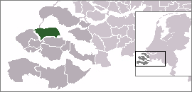
town_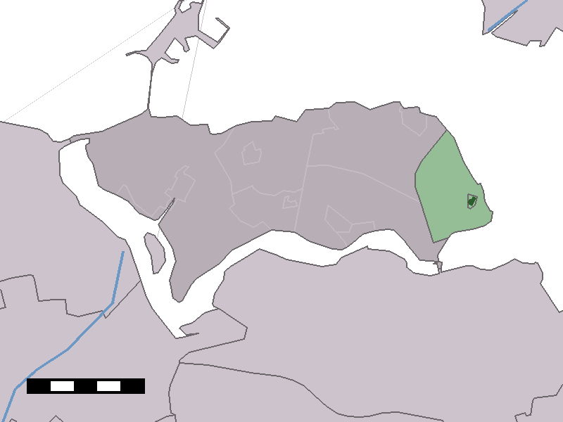
caption = The town centre (dark green) and the statistical district (light green) of Kats in the municipality of Noord-Beveland.Kats (coord|51|34|N|3|53|E|type:city(286)) is a town in the Dutch province of
Zeeland . It is a part of the municipality ofNoord-Beveland , and lies about 20 km east ofMiddelburg .In 2001, the town of Kats had 286 inhabitants. The built-up area of the town was 0.072 km², and contained 162 residences.cite web
publisher=Statistics Netherlands (CBS)
title=Bevolkingskernen in Nederland 2001
url=http://www.cbs.nl/nl-NL/menu/themas/milieu-natuur-ruimte/ruimte/publicaties/cartografie-geografie/geografische-data/2001-bevolkingskernen-in-nederland.htm ] The statistical area "Kats", which also can include the surrounding countryside, has a population of around 430.In the
Middle ages Kats originally prospered as "Suburchdijke" the name alluding to connections with the nearby city ofSouburg . The local inhabitants are referred to locally as "katsenaers" and 150 of them were drowned in flooding caused by a great storm on5 November 1530 , which engulfed the whole island, then in 1532 theElizabethflood swept away all the remaining buildings.Poldering Noord Beverland (the process the Dutch invented to reclaim land from the sea) didn’t start again until 1598 - the villages ofColijnsplaat and Kats were both built on estates at right angles to each other.The name “Kats” probably originates from a family- a certain "Caths" was granted the deeds. Kats grew very slowly and was blighted by the plagues of 1603 to 1605 and 1650. By 1629 a windmill had been built and 30 years later in 1659 enough people were living there to establish a reformed church parish. The first minister was Johannes Jones, like other inhabitants of the time he was born in England. The name Jones hints at Welsh ancestry. In 1687 the present day church was built.
In 1922 the mill was demolished. In the thirties discussions were held about redrawing municipal boundaries and in 1941 Kats,
Colijnsplaat andKortgene were joined together as the municipality of Kortgene with it’s administrative centre in Kortgene, in recent years this has become the municipality of Noord Beverland, all administration being transferred to the new council building in Wissenkerke. Sections for the suspended road connecting the islands of the massiveNeeltje Jans flood prevention scheme were built at Kats.With art galleries but no shops or cafes present day Kats is a picturesque village set on fire in rural environs it has attracted many resident artists and musicians. It’s largely unspoilt dorpstraat (or village street) has won awards for being the prettiest village street in Zeeland. There is a small yachting marina located near the Zeeland Bridge on the Oosterschelde and De Zeeuwse Rozentuin (The Rose garden of Zeeland) is open to the public growing as it does over 1000 varieties of roses spread over more than 4 hectares, it also possesses an open air theatre. The nature reserve “De Kaatseplaat” is to be found nearby in the Oosterschelde and it’s upkeep administered by the Dutch natural monument society or Vereniging tot behoud van natuurmonumenten
Points of interest
Local legend tells of a 15th century inn or hostel in Kats called the "Sun and the Moon". Here the Dutch humanist
Erasmus supposedly met withThomas More and the name may have inspired some of More's writings.cite web | publisher = Statistics Netherlands (CBS)
title=Statline: Kerncijfers wijken en buurten 2003-2005"
url=http://statline.cbs.nl
accessdate=2005-01-01]References
Wikimedia Foundation. 2010.