Vijfhuizen

Vijfhuizen

Dutch town locator maps
mun_


town_


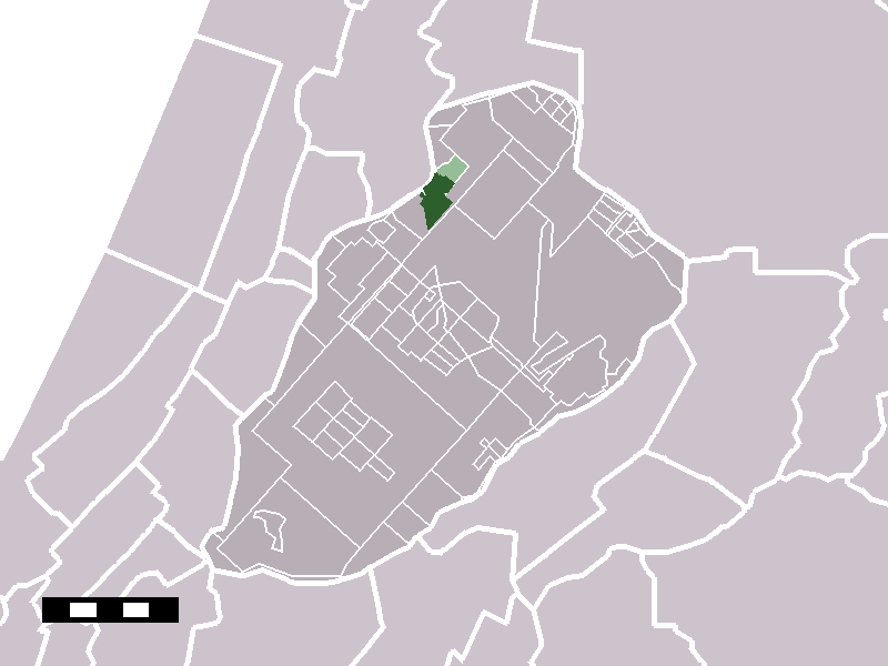
caption = The town centre (darkgreen) and the statistical district (lightgreen) of Vijfhuizen in the municipality of Haarlemmermeer.

Vijfhuizen (coord|52|21|N|4|41|E|type:city(1832)) is a town in the Dutch province of North Holland. It is a part of the municipality of Haarlemmermeer, and lies about 4 km southeast of Haarlem.

In 2001, the town of Vijfhuizen had 1832 inhabitants. The built-up area of the town was 0.48 km², and contained 728 residences.Statistics Netherlands (CBS), "Bevolkingskernen in Nederland 2001" [http://www.cbs.nl/nl-NL/menu/themas/milieu-natuur-ruimte/ruimte/publicaties/cartografie-geografie/geografische-data/2001-bevolkingskernen-in-nederland.htm] . Statistics are for the continuous built-up area.] The wider statistical area of Vijfhuizen has a population of around 2800.Statistics Netherlands (CBS), "Gemeente Op Maat 2004: Haarlemmermeer" From 2002 a new Vinex location has been build along Vijfhuizen, expanding the size of the village to twize the size, approximately 5000 inhabits. [http://www.cbs.nl/nl-NL/menu/themas/nederland-regionaal/nederland-regionaal/publicaties/gemeente-op-maat/2004/alfabet/H/2004-haarlemmermeer.htm] .]

Monuments and parks

* Fort Vijfhuizen is part of the Stelling van Amsterdam and a World Heritage Site. It is currently home to a charitable foundation run by volunteers with 12 art studios and a restaurant.
* Vijfhuizen bridge

References


Wikimedia Foundation. 2010.

Игры ⚽ Поможем написать курсовую

Look at other dictionaries:

  • Vijfhuizen —  Cette page d’homonymie répertorie les différents lieux partageant un même toponyme.  Pays Bas Vijfhuizen est un toponyme néerlandais signifiant Cinq Maisons : Vijfhuizen, hameau de la commune de …   Wikipédia en Français

  • Vijfhuizen (Hollande-Septentrionale) — 52°20′60″N 4°40′38″E / 52.35, 4.67722 …   Wikipédia en Français

  • Fort Vijfhuizen — is one of forty two forts in the Defense Line of Amsterdam (Dutch: stelling van Amsterdam ), a World Heritage Site. It is located in the town of Vijfhuizen on the ringvaart which surrounds the Haarlemmermeer polder. The main fort is currently… …   Wikipedia

  • Stellung von Amsterdam — Verlauf der Stellung von Amsterdam …   Deutsch Wikipedia

  • Zwanenburg — 52°22′41″N 4°44′47″E / 52.37806, 4.74639 …   Wikipédia en Français

  • Stelling Amsterdam — Verlauf der Stellung von Amsterdam Kehlseite des Forts südlich von Spaarndam Die Stellung von Amsterdam (niederländisch …   Deutsch Wikipedia

  • Stelling van Amsterdam — Verlauf der Stellung von Amsterdam Kehlseite des Forts südlich von Spaarndam Die Stellung von Amsterdam (niederländisch …   Deutsch Wikipedia

  • Stellung Amsterdam — Verlauf der Stellung von Amsterdam Kehlseite des Forts südlich von Spaarndam Die Stellung von Amsterdam (niederländisch …   Deutsch Wikipedia

  • Ringvaart — The Ringvaart (known in full as Ringvaart of the Haarlemmermeer Polder) is a canal in the province of North Holland, the Netherlands. The Ringvaart (Dutch meaning ring canal ) is a true circular canal surrounding the Haarlemmermeer polder and… …   Wikipedia

  • Museum De Cruquius — Back of Cruquiusmuseum, showing the beams of the pumping engine and the 9 meter drop in water level from the Spaarne river …   Wikipedia

Share the article and excerpts

Direct link
Do a right-click on the link above
and select “Copy Link”