- Polsbroek
Dutch town locator maps
mun_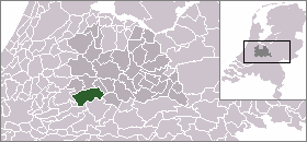
town_
caption = The town centre (darkgreen) and the statistical district (lightgreen) of Polsbroek in the municipality of Lopik.Polsbroek (coord|51|59|N|4|51|E|type:city(421)) is a town in the Dutch province of Utrecht. It is a part of the municipality of
Lopik , and lies about 10 km southeast ofGouda . The village of Polsbroek consists of a ribbon of farms on both sides of the Benschopse Wetering, with a small town centre on the west side of the village.In 2001, the town centre of Polsbroek had 421 inhabitants. The built-up area of the town was 0.06 km², and contained 143 residences.Statistics Netherlands (CBS), "Bevolkingskernen in Nederland 2001" [http://www.cbs.nl/nl-NL/menu/themas/milieu-natuur-ruimte/ruimte/publicaties/cartografie-geografie/geografische-data/2001-bevolkingskernen-in-nederland.htm] . Statistics are for the continuous built-up area.] The wider statistical area of Polsbroek, which covers the complete former municipality, including the ribbon of farms and the village of Polsbroekerdam, has a population of 1190, and an area of about 11 km².Statistics Netherlands (CBS), "Gemeente Op Maat 2004: Lopik" [http://www.cbs.nl/nl-NL/menu/themas/nederland-regionaal/nederland-regionaal/publicaties/gemeente-op-maat/2004/alfabet/l/2004-lopik.htm] .]
Until 1857, Polsbroek was divided along the Benschopse Wetering into two municipalities,
Noord-Polsbroek andZuid-Polsbroek . From 1857 to 1989, Polsbroek was a single separate municipality.References
External links
* [http://www.kuijsten.de/atlas/ut/polsbroek.html Map of Polsbroek in 1868]

Wikimedia Foundation. 2010.