- Lopikerkapel
Dutch town locator maps
mun_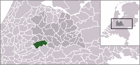
town_
caption = The town centre (darkgreen) and the statistical district (lightgreen) of Lopikerkapel in the municipality of Lopik.Lopikerkapel (coord|51.60|N|5.3|E|type:city(145)) is a town in the Dutch province of Utrecht. It is a part of the municipality of
Lopik , and lies about 3 km south ofIJsselstein . The village has a very small town centre, with a church, but mostly consists of a ribbon of farms on both sides of the Enge IJssel river. The name "Lopikerkapel" means "Lopik's chapel".In 2001, the town centre of Lopikerkapel had 145 inhabitants. The built-up area of the town was 0.03 km², and contained 47 residences.Statistics Netherlands (CBS), "Bevolkingskernen in Nederland 2001" [http://www.cbs.nl/nl-NL/menu/themas/milieu-natuur-ruimte/ruimte/publicaties/cartografie-geografie/geografische-data/2001-bevolkingskernen-in-nederland.htm] . Statistics are for the continuous built-up area.] The wider statistical area of Lopikerkapel, also covering the ribbon of farms, has a population of around 640.Statistics Netherlands (CBS), "Gemeente Op Maat 2004: Lopik" [http://www.cbs.nl/nl-NL/menu/themas/nederland-regionaal/nederland-regionaal/publicaties/gemeente-op-maat/2004/alfabet/l/2004-lopik.htm] .]
References

Wikimedia Foundation. 2010.