- Pearl River (Mississippi-Louisiana)
Infobox River | river_name = Pearl River

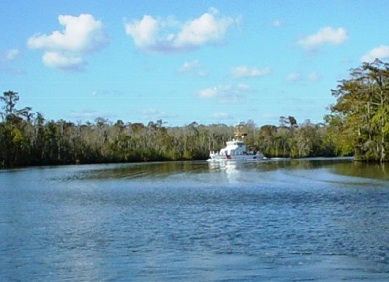
caption = The US Coast Guard Cutter Pompano transiting the Pearl River
origin =Winston County, Mississippi
mouth =Lake Borgne
basin_countries =U.S.
length = 781 km (485 mi)
elevation = 175 m (575 ft)
discharge =
watershed = 22,700 km² (8,760 mi²)The Pearl River is ariver in the U.S. states ofMississippi andLouisiana . It forms in Winston County,Mississippi from the confluence of Nanawaya and Tallahaga Creeks.cite web
title=Topography & History
work=Pearl River Basin Development District
url=http://www.pearlriverbasin.com/topography_and_history.php
accessdate=2006-04-21] It is 790 kilometers (490 mi) long.cite web
title=The Pearl River Basin
work=USGS – The Rivers of Mississippi
url=http://ms.water.usgs.gov/ms_proj/eric/pearl.html
accessdate=2006-04-21] The Yockanookany andStrong River s are tributaries. Northeast of Jackson, theRoss Barnett Reservoir is formed by a dam.The Pearl passes near or through the following towns (in order, north to south):
*Philadelphia, Mississippi
*Pearl River, Mississippi
*Carthage, Mississippi
*Jackson, Mississippi
*Georgetown, Mississippi
*Rockport, Mississippi
*Monticello, Mississippi
*Columbia, Mississippi
*Bogalusa, Louisiana
*Picayune, Mississippi
*Pearl River, Louisiana West of Picayune, about 80 km (50 mi) above the mouth, the river forks. The East Pearl River empties into Lake Borgne where the dredged Pearl River Channel meets the
Gulf Intracoastal Waterway . The discharge flows eastward past Grand Island through St. Joe Pass and into theMississippi Sound . [cite web
title=Conservation Habitats and Species Assessments
work=Louisiana Dept. of Wildlife & Fisheries
format=PDF
url=http://www.wlf.state.la.us/pdfs/experience/Pearl.pdf
accessdate=2006-04-21] The West Pearl River, on the other hand, flows intoThe Rigolets , thence into Lake Borgne. [cite web
title=Title 33, Chapter 32, § 1804. Inland and intracoastal waterways of the United States
work=U.S. Code Collection, Legal Information Institute, Cornell Law School
url=http://www4.law.cornell.edu/uscode/html/uscode33/usc_sec_33_00001804----000-.html
accessdate=2006-04-24] Both discharges eventually reach the Gulf of Mexico.The Pearl River serves as the 187-kilometer (116-mi) boundary between Mississippi and Louisiana, in its lower reach near the
Gulf of Mexico .The
U.S. Army Corps of Engineers has undertaken three significant navigation projects in the Pearl River Basin. In 1880, Congress authorized a 1.5-meter (5 ft) navigation channel on the West Pearl River from Jackson to the Rigolets. That project was discontinued in 1922. Beginning in 1910, a channel was dredged from the mouth of the East Pearl River into Lake Borgne, a project which is maintained on an irregular basis. In 1935, the West Pearl River Navigation Project was authorized. It provided for a navigation channel from Bogalusa to the mouth of the West Pearl River. The project includes a canal with three locks. The Corps of Engineers placed the project in "caretaker" status in the 1970s because of a decline in commercial traffic. Maintenance dredging resumed in December 1988. [cite web
title=State of Mississippi v. U.S. (1990)
work=Government Briefs, Office of the Solicitor General, U.S. Dept. of Justice
url=http://www.usdoj.gov/osg/briefs/1990/sg900345.txt
accessdate=2006-04-24]In the 1950s, underwater concrete sills were constructed to help maintain water levels in the navigation channel. This has prevented Gulf sturgeon and other migratory species from accessing upstream areas. A rock ramp constructed in 2003 helps fish navigate over one of the sills, [cite web
title=Project #1003 - Fisheries Habitat Restoration in the Pearl River
work=Gulf of Mexico Foundation
url=http://www.gulfmex.org/crp1003.html
accessdate=2006-04-24] but environmental groups propose further work to mitigate the effects of the navigation project. [cite web
title=Comprehensive Habitat Management Plan for the Lake Pontchartrain Basin
work=Lake Pontchartrain Basin Foundation
year=2006-02-26
format=PDF
url=http://www.saveourlake.org/pdfs/CHMP_22706_Exec.pdf
accessdate=2006-04-24]Hurricane Katrina in August 2005 caused extensive damage in the Pearl River. Bottom sediments and marsh vegetation—including uprooted cypress and oak trees—blocked the mouth of the West Pearl and other parts of the channel, preventing navigation and diverting flow. The Louisiana Department of Wildlife & Fisheries and other agencies removed 27,000 cubic meters (35,000 yd³) of debris. [cite news
url=http://www.nola.com/newslogs/tpupdates/index.ssf?/mtlogs/nola_tpupdates/archives/2005_12_14.html#099699
title=West Pearl being cleared of debris
work=New Orleans Times-Picayune
date=2005-12-14
accessdate=2006-04-24 ]The country music band Pearl River named itself after this river. In wrestling, Ahmed Johnson's finishing maneuver was known as the Pearl River Plunge.
References
Wikimedia Foundation. 2010.
