- Kamchiya
Infobox River | river_name = Kamchiya (Камчия)
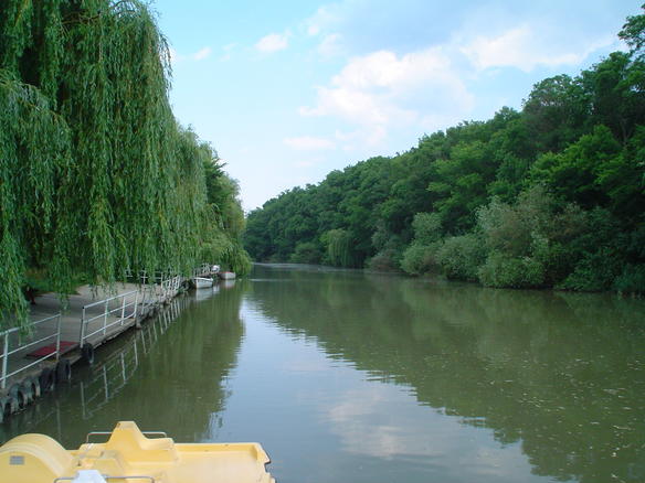
caption = Kamchiya
origin =Bulgaria
mouth =Black Sea , 25 km south ofVarna
basin_countries =Bulgaria
length = 244.5 km
elevation = 710 m
discharge = from 1,136 m³/s at the village of Ticha to 26,287 m³/s at the mouth
watershed = 5,358 km²The Kamchiya (also Kamchia and Kamčija, Bulgarian: Камчия, _gr. Panisos) is a 244.5 km long river in eastern
Bulgaria , the longest river on theBalkan Peninsula to flow directly into theBlack Sea . It starts from the confluence of two rivers springing from EasternStara Planina , Golyama Kamchiya (itself formed by the confluence of the rivers Ticha and Vrana) and Luda Kamchiya, flows eastward to theBlack Sea and empties into it 25 km south ofVarna .In antiquity, the river was known as "Panisos"; later,
Slavs gave it the name of "Ticha". Its contemporary name is considered to be of Cuman origin. The Romans built the stronghold "Erite" on its bank. The Kamchia bassin played a notable role in the history of theFirst Bulgarian Empire . Much of theMedieval Bulgarian Navy from the 9th to the 14th century was built at the river mouth thanks to the quality timber of the area. In the 18th century,Lipovans settled along the lower banks.Running down through Eastern
Stara Planina , Kamchiya meanders through the "Longoz" or alluvial longose grove, a [http://www.unesco.org/mabdb/br/brdir/directory/biores.asp?code=BUL+08&mode=all UNESCO-listed]biosphere reserve protecting the primeval forest from intensive logging and drainage that had decimated it by mid-20th century. The river mouth forms a sand barrier and often overflows its banks to the valley. The old synclines of the river leave swampy areas called azmatsi. The reserve is 40 km long (stretching throughout the longose grove to the river mouth) and up to 5 km wide.The area around the mouth is remarkable for its variety - frequently flooded,
old growth forest s of a riverine type, up to 450 m-wide beaches with up to 19 m-high, forested or grass-covered sand dunes, freshwater marshes and marshy remnants of old riverbeds, cutting deep into the forest. The unusual coexistence of ash,oak ,elm ,alder andmaple trees sometimes rising up to 40-50 m with lianas climbing between the branches creates the impression of a tropical forest, a real tangle of woods. The summer snowflake (Leucojum aestivum) and severalbuttercup species (Scilla sp.), as well asfern s, grow in the delta. One can seeotter ,doe ,deer ,wild boar andwild cat , among 26 mammal species,sea hawk s,eagle s, and up to 200 other bird species, including 56 protected ones, and 25 fish species, among others.The towns the river flows by include
Veliki Preslav andSmyadovo inShumen Province ,Dalgopol andDolni Chiflik inVarna Province . Ticha feeds dam lake Ticha and Luda Kamchiya feeds dam lakes Kamchiya and Tsonevo supplying water to Varna andBurgas . Lake Tsonevo is also a preferred fishing spot for much of Eastern Bulgaria. The Luda Kamchiya gorge cutting across Stara Planina provides the easternmost of the three railway routes between northern and southern Bulgaria. The river valley is fertile, lined with orchards and vegetable gardens; much of it is irrigated. The lower Kamchiya is navigable for smaller motor boats.Honour
Kamchiya Glacier onLivingston Island in theSouth Shetland Islands ,Antarctica is named for Kamchiya River.
Wikimedia Foundation. 2010.