- Lan Kwai Fong
-
Lan Kwai Fong Traditional Chinese 蘭桂坊 Cantonese Jyutping laan4 gwai3 fong1 Transcriptions Mandarin - Hanyu Pinyin Lánguì Fāng Cantonese (Yue) - Jyutping laan4 gwai3 fong1 - Yale Romanization laáhn gwai fòng  Lan Kwai Fong's bars spread to D'Aguilar Street
 Lan Kwai Fong
Lan Kwai Fong is a small square of streets in Central, Hong Kong. The area was dedicated to hawkers before the Second World War, but underwent a renaissance in the mid 1980s. It is now a popular expatriate haunt in Hong Kong for drinking, clubbing and dining. The street Lan Kwai Fong is an L-shape with two ends joining with D'Aguilar Street.
Contents
History
Before the Second World War, Lan Kwai Fong was previously dedicated to hawkers.
In early days, the square housed many mui yan (媒人, lit. medium person), or marriage arrangers, a role exclusively held by females. Mui yan was a marriage medium between two families in the olden days. It was thus known as Mui Yan Hong (媒人巷, lit. medium person lane) or Hong Leung Hong (紅娘巷).
In 1975, German-Canadian businessman Allan Zeman, also known as the father of Lan Kwai Fong,[1] moved to Hong Kong. He felt it needed a western style restaurant, so he opened “California” in 1983 in Lan Kwai Fong which became his claim to fame. One year later, following this success, Zeman invested HK$32 million to buy a whole block and began a new career as an entertainer and property developer eventually founding the Lan Kwai Group and developing this location into one of Hong Kong’s most popular entertainment destinations for expatriates as well as tourists. Friday and Saturday nights are often jammed with people, leading to vehicle traffic being suspended at certain times, giving the streets over to pedestrians. The square, together with a gay club "Disco Disco" founded earlier in 1978 in D'Aguilar Street, made Lan Kwai Fong and its surroundings a famous spot for night life.[citation needed]
Location
 Lan Kwai Fong at night.
 On a public holiday morning, Lan Kwai Fong
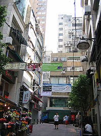 Lan Kwai Fong in the daytime.
Lan Kwai Fong as an area is defined by D'Aguilar Street and the smaller lane, Lan Kwai Fong, an L-shaped, cobble-stoned lane. Both streets turn 90 degrees to form a rectangle. From the west side of the rectangle, Wo On Lane and Wing Wah Lane extend to host several more spots for drinks and food. The area arguably extends to Wellington Street and Wyndham Street, through to the Hong Kong Fringe Club. It is also home to a small number of art galleries.
Special occasions
The crowds during special occasions such as Halloween or New Year's Eve put the place at a literal standstill with the large numbers. Police control is guaranteed, to manage the crowds. [2]
Stampede
On 1 January 1993, 21 people were killed and 48 injured in a large-scale human stampede whilst celebrating the New Year's Day in Lan Kwai Fong.[3] The location's narrow streets and a sloped gradient, poor police planning and bad weather all contributed to this disaster.
More than 15,000 people were crammed into the area for the New Year countdown at the time.[4] The Hong Kong government appointed then-Court of First Instance judge Kemal Bokhary to conduct an inquest into the disaster.[5] The stringent crowd control measures now in force at major holiday events are a direct consequence of the inquest's recommendations.
Transport
There are several ways to access Lan Kwai Fong other than taxi, which include:
- MTR, Central Station, Exit "D2"
- Airport Express, Hong Kong Station, Exit "B2"
- Public bus, route no. 12m, 13, 23A and 40M
See also
- Soho, Hong Kong
- Central and Western district
- Wan Chai district
- Mid-levels
- List of buildings, sites and areas in Hong Kong
- List of streets and roads in Hong Kong
References
- ^ 盛智文 蘭桂坊之父
- ^ 蘭桂坊:廿四味與啤酒共存
- ^ 蘭桂坊:廿四味與啤酒共存
- ^ King of the hill looks to Hollywood's heights SCMP, 27 Mar 2006
- ^ "包致金女兒曾涉高買", Oriental Daily News, 2010-01-28, http://www2.news.sina.com.hk/cgi-bin/nw/show.cgi/2/1/1/1410422/1.html, retrieved 2010-01-30
External links
- Official website of Lan Kwai Fong Association
- Official website of Lan Kwai Fong Entertainments
- I Love LKF - Your Guide to everything at LKF
Coordinates: 22°16′51.5″N 114°9′19.9″E / 22.280972°N 114.155528°E
Streets and roads on Hong Kong Island Central and Western District Aberdeen Street • Albany Road • Albert Path • Arbuthnot Road • Babington Road • Barker Road • Bank Street • Battery Path • Belcher's Street • Bluff Path • Bonham Road • Bonham Strand • Bonham Strand West • Borrett Road • Bowen Drive • Breezy Path • Brewin Path • Bridges Street • Burd Street • Burrows Street • Cadogan Street • Caine Road • Centre Street • Chater Road • Cochrane Street • Conduit Road • Connaught Road Central • Connaught Road West • Connaught Place • Davis Street • Des Voeux Road Central • Des Voeux Road West • Duddell Street • Elgin Street • Eastern Street • Gage Street • Garden Road • Gilman Street • Gilman's Bazaar • Glenealy • Gutzlaff Street • Harcourt Road • Hing Hon Road • Hollywood Road • Ice House Street • Jubilee Street • Kennedy Town Praya • Ladder Street • Lambeth Walk • Lan Kwai Fong • Lugard Road • Macdonnell Road • Magazine Gap Road • Man Cheung Street • Man Kwong Street • Man Yiu Street • Mount Austin Road • Mount Kellett Road • Murray Road • Old Bailey Street • Old Peak Road • Pottinger Street • Peel Street • Queen Victoria Street • Queen's Road Central • Queen's Road West • Queensway • Robinson Road • Smithfield • Staveley Street • Tai Ping Shan Street • Tim Wa Avenue • Tim Mei Avenue • Upper Albert Road • Upper Lascar Row • Water Street • Wellington Street • Western Street • Wing Kut Street • Wing On Street • Wing Sing Street • Wyndham StreetWan Chai District Amoy Street • Anton Street • Arsenal Street • Blue Pool Road • Boat Street • Boyce Road • Briar Avenue • Broadwood Road • Broom Road • Brown Street • Bullock Lane • Canal Road East • Canal Road West • Cleveland Street • Gloucester Road • Gresson Street • Hennessy Road • Jaffe Road • Jardine's Bazaar • Johnston Road • Lee Tung Street • Li Chit Street • Lockhart Road • Lun Fat Street • Oi Kwan Road • Paterson Street • Queen's Road East • St. Francis Street • Stone Nullah Lane • Stubbs Road•Swatow Street • Tai Wong Street West • Tai Wong Street East • Tai Yuen Street • Thomson Road • Wood Road • Yee Wo StreetEastern District A Kung Ngam Road • Aldrich Bay Road • Aldrich Street • Basel Road • Braemar Hill Road • Chai Wan Road • Harbour Parade • Hong Shing Street • King's Road • Shau Kei Wan Road • Siu Sai Wan Road • Tai Koo Shing Road • Tai Koo Wan Road • Tai Mou Avenue • Tsat Tsz Mui Road • Wharf RoadSouthern District Aberdeen Main Road • Aberdeen Praya Road • Aberdeen Reservoir Road • Ap Lei Chau Bridge Road • Ap Lei Chau Drive • Ap Lei Chau Praya Drive • Beach Street • Bel-air Avenue • Bel-air Rise • Belleview Drive • Big Wave Bay Road • Bisney Road • Black's Link • Sassoon RoadSpans more than one district See also: Streets and roads in Kowloon • The New Territories
Categories:- Central, Hong Kong
- Visitor attractions in Hong Kong
- Roads in Hong Kong


Wikimedia Foundation. 2010.