Pembridge Castle

Pembridge Castle
Pembridge Castle
Welsh Newton, Herefordshire, England
Pembridge Castle.jpg
Pembridge Castle
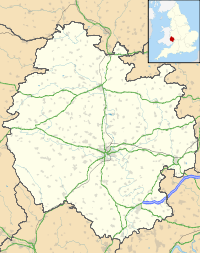
Pembridge Castle is located in Herefordshire
Shown within Herefordshire
Type Bailey
Coordinates grid reference SO488192
Construction
materials
Stone
Current
owner
Private

Pembridge Castle, originally called Newland Castle[1], is a late 12th century to early 13th century Grade I listed former border castle located approximately 1 mile (1.6 km) northwest of Welsh Newton in Herefordshire, England.

It was most likely constructed by Matilda de St Valery sometime before 1208. It is over 40 km (25 mi) away from the actual village of Pembridge.[2] Founded by 1208, it was the seat of the Pembridge family, then later the Wakes and Mortimer families in the 14th and 15th centuries. The chapel is 16th century and was ruined in 1644 during the English Civil War. Much reconstruction of the castle was undertaken in the early 20th century by a Dr Hedley Bartlett. It remains in private ownership.

The castle sits on a 36 m x 27 m plot of land and is surrounded by a moat. It is constructed of ashlar, sandstone and rubble walls. The curtain wall surrounding the castle is 1.4 m thick. The earliest part of the castle, thought to be the keep, is the four story round tower on the western corner. The internal diameter of the tower is 7.5 m and the internal rooms of the tower are 5 m wide. [1]

See also

References

  1. ^ a b Castle Description from 'Castles of Herefordshire'
  2. ^ Hereford and Leominster (Landranger Maps) (B2 ed.), Ordnance Survey, 2007, ISBN 978-0319229538 
  • Remfry, Paul Martin. Newland or Pembridge Castle, Welsh Newton C. 1090 to 1646. ISBN 1-899376-45-3. 

External links

Coordinates: 51°52′12″N 2°44′42″W / 51.870°N 2.745°W / 51.870; -2.745


Wikimedia Foundation. 2010.

Игры ⚽ Поможем сделать НИР

Look at other dictionaries:

  • Pembridge — is a village located just south of the River Arrow at coord|52|13|N|02|53|W| in the English county of Herefordshire.Describing itself as The Jewel in the Crown of the Black and White Village Trail , Pembridge has a history stretching back at… …   Wikipedia

  • John Kemble (martyr) — John Kemble (b. 1599, St Weonards, Herefordshire d. 22 August 1679, Widemarsh Common, Hereford) was an English Roman Catholic martyr. He was one of the Forty Martyrs of England and Wales.Early years and ordinationJohn Kemble was born at Rhydicar… …   Wikipedia

  • Welsh Newton — is a small village and civil parish in the county of Herefordshire within the United Kingdom. It is in England, however the village is less than one mile from the border with Wales to which the parish extends.The parish of Welsh Newton (which is… …   Wikipedia

  • Ven. John Kemble —     Ven. John Kemble     † Catholic Encyclopedia ► Ven. John Kemble     Martyr, b. at Rhydicar Farm, St. Weonard s, Herefordshire, 1599; d. at Widemarsh Common, Hereford, 22 August, 1679; son of John Kemble, formerly of Kemble, Wiltshire,… …   Catholic encyclopedia

  • List of night buses in London — Night buses in London are after hours versions of their daytime numerical equivalents, normally running the same route but with extensions at either end of the service. This is normally to provide a night service to destinations served by tube or …   Wikipedia

  • London Buses route 31 — Infobox London Bus number=31 ibus=yes operator=First London garage=Westbourne Park vehicle= Volvo B7TL/Wright Eclipse Gemini start=Shepherd s Bush Green end=Camden Town via=Notting Hill Gate Westbourne Park Maida Hill Kilburn Swiss Cottage length …   Wikipedia

  • Bernard de Neufmarché — Bernard of Neufmarché or Newmarket (c. 1050 ndash; c. 1125) was the first of the original conquerors of Wales. [Nelson, 123.] He was a minor Norman lord who rose to power in the Welsh Marches before successfully undertaking the invasion and… …   Wikipedia

  • Merthyr Tydfil — For the town in Australia, see Merthyr, Queensland. Merthyr Tydfil County Borough Bwrdeisdref Sirol Merthyr Tudful Geography …   Wikipedia

  • Lyonshall — infobox UK place country =England static static image caption=View of Lyonshall village from the south official name=Lyonshall latitude= 52.195 longitude= 2.971 os grid reference=SO3355 london distance= population =750 shire district= lieutenancy …   Wikipedia

  • Cowes — This article is about the town on the Isle of Wight. For the town on Phillip Island, Australia, see Cowes, Victoria. Coordinates: 50°45′34″N 1°18′01″W / 50.7595°N 1.3002°W …   Wikipedia

Share the article and excerpts

Direct link
Do a right-click on the link above
and select “Copy Link”