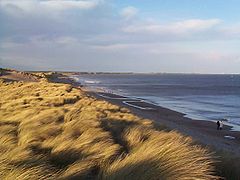
- Druridge Bay
-
Coordinates: 55°16′44″N 1°34′01″W / 55.279°N 1.56708°W
Druridge Bay 
Druridge Bay
 Druridge Bay shown within Northumberland
OS grid reference NZ276984 List of places: UK • England • Northumberland Druridge Bay is a 7 miles (11 km) long coastal bay in Northumberland, England, stretching from Amble in the north to Cresswell in the south.
Northumberland Coast Country Park is situated within the bay, and part of the bay (the section near the village of Druridge, in the centre of the bay) is owned by the National Trust. Areas within the bay are set aside as nature reserves.
During the Second World War defences were constructed around Druridge Bay as a part of British anti-invasion preparations of World War II. The defences included scaffolding barriers and anti-tank blocks overlooked by pillboxes and behind these were minefields and an anti-tank ditch.[1]
The bay was the focus of a long-running campaign against a proposal to construct a Pressurised Water Reactor nuclear power station during the 1980s and the large scale extraction of sand from the area in the 1990s. The campaign, along with changes in UK Government policy on nuclear power, prevented the power station from being built, and the plan was finally shelved in 1989. Northumberland Wildlife Trust are presently negotiating with landowners RMC Group to purchase the site, which is known for population of birds including the Golden Plover and the Purple Sandpiper.
Druridge Bay is best known to birdwatchers for hosting, in 1998, the Druridge Bay curlew, a controversial bird which was eventually accepted as the first record of Slender-billed Curlew for Britain, although this identification is still disputed by some.
References
Notes
- ^ Foot, 2006, p199.
General references
- Foot, William (2006). Beaches, fields, streets, and hills ... the anti-invasion landscapes of England, 1940. Council for British Archaeology. ISBN 1-902771-53-2.
External links
Categories:- Bays of England
- Geography of Northumberland
Wikimedia Foundation. 2010.


