Chornohora

Chornohora
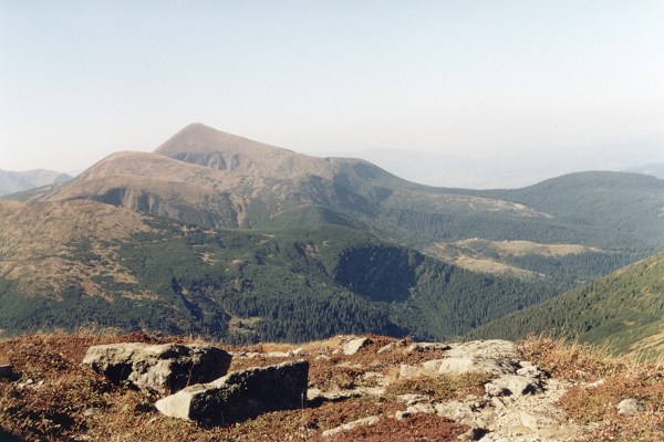
North part of Chornohora with Hoverla

Chornohora (literally: Black Mountain, Ukrainian: Чорногора, Polish: Czarnohora, Hungarian: Feketebérc) is the highest mountain range in Western Ukraine in the Eastern Beskids and the Ukrainian Carpathians group, which in turn is part of the Outer Eastern Carpathians.

It is adjacent to the Gorgany range. The highest peak of Chornohora is Hoverla (2,062 m) with other high peaks including Pop Ivan (2,022 m) and Petros (2,020 m). The mountains are made of flysch rock.

The major part of the range forms the watershed between the Prut and Tysa River. The lower parts of Chornohora are inhabited by Hutsuls, whose primary occupation is herding. Major tourist centres of Chornohora are Bystrets, Rakhiv, Verkhovyna, Vorokhta and Yasinia.

External links

  • Chornohora - photographs and information in Czech


Wikimedia Foundation. 2010.

Игры ⚽ Поможем написать реферат

Look at other dictionaries:

  • Chornohora — Sp Čornohorà Ap Чорногора/Chornohora L Karpatų dalis PV Ukrainoje …   Pasaulio vietovardžiai. Internetinė duomenų bazė

  • FC Chornohora Ivano-Frankivsk — is a Ukrainian football club based in Ivano Frankivsk. It plays in the Oblast Championship. It used to compete in the Druha Liha …   Wikipedia

  • Yaroslav Hodzyur — Football player infobox playername= Yaroslav Hodzyur fullname = nickname = dateofbirth = Birth date and age|1985|3|6|mf=y cityofbirth = countryofbirth = height = height|meters=1.94 currentclub = FC Terek Grozny position = Goalkeeper youthyears =… …   Wikipedia

  • Igor Khudobyak — Igor Khudobyak …   Wikipédia en Français

  • Rudolf Wilczek — Rudolf Wilczek, né le 1er novembre 1903 à Cierpisz, Voïvodie de Cracovie, mort le 19 mai 1984 à Bruxelles, est un botaniste polonais du Jardin botanique de l État à Bruxelles (actuellement Jardin botanique national de… …   Wikipédia en Français

  • Tisza — Tisa redirects here. For other uses, see Tisa (disambiguation) and Tisza (disambiguation). Geobox River name =Tisza River native name = other name = ro. Tisa ry. Тиса uk. Тиса sk. Tisa sr. Тиса/Tisa other name1 = image size = 300 image caption =… …   Wikipedia

  • Hoverla — Infobox Mountain Name=Hoverla Photo= Howerla.jpg Caption=Hoverla, September 2003 Elevation=2,061 metres (6,761 ft) Range=Carpathians Location=flag|Ukraine Prominence = pushpin pushpin label position = right pushpin map caption = pushpin mapsize …   Wikipedia

  • Zakarpattia Oblast — Infobox Ukrainian oblast Name = Zakarpattia Oblast UkrainianName = Закарпатська область TransliteratedName = Zakarpats’ka oblast’ Nickname = Закарпаттяspaces|2(Ukrainian) Zakarpattia spaces|2(transliteration) Transcarpathia Ukraine OfficialLang …   Wikipedia

  • Stanisławów Voivodeship — ( pl. Województwo stanisławowskie; uk. Станіславське воєводство) was an administrative unit of interwar Poland (1918 1939). It ceased to exist in September of 1939, following German and Soviet aggression on Poland (see: Invasion of… …   Wikipedia

  • Divisions of the Carpathians — Map of the main divisions of the Carpathians. 1. Outer Western Carpathians 2. Inner Western Carpathians 3. Outer Eastern Carpathians 4. Inner Eastern Carpathians 5. Southern Carpathians 6. Western Romanian Carpathians 7. Transylvanian Plateau 8.… …   Wikipedia

Share the article and excerpts

Direct link
Do a right-click on the link above
and select “Copy Link”