- Coverack
-
For the schooner, see Coverack (schooner).
Coordinates: 50°01′N 5°06′W / 50.017°N 5.1°W
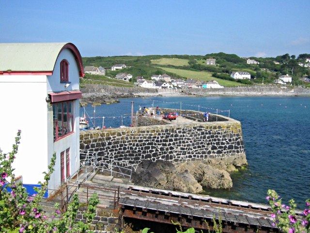
 Coverack Old Lifeboat Station and Harbour Wall
Coverack (Cornish: Porthkovrek) is a coastal village and fishing port in Cornwall, England, UK. It is situated on the east side of the Lizard peninsula approximately nine miles south of Falmouth.[1]
Coverack has several hotels and a youth hostel.[2] The area is a centre for watersports, particularly wind surfing, sailing and diving. The nearby rocks known as The Manacles have been the site of many shipwrecks and as a consequence are now a favourite diving destination.
Contents
Geography
Near the South West Coast Path is Poldowrian Garden which includes a prehistoric settlement discovered in 1965, dated by archaeologists at 5500 BC. Finds from the site are available for viewing.[3] The roads to Coverack cross Goonhilly Downs (famous for the BT satellite earth station).
"Coverack Cove and Dolor Point" SSSI (Site of Special Scientific Interest) is one of the most famous geological localities in Cornwall, providing an almost continuous section across a mantle-crust boundary.[4] Other nearby SSSI are Coverack to Porthoustock and Kennack to Coverack.
Coverack Lifeboat
The Royal National Lifeboat Institution (RNLI) stationed a lifeboat at Coverack in 1901 following the wreck of the SS Mohegan on The Manacles in 1898 with the loss of more than 100 lives. A boat house with a slipway was built on the harbour. The station was closed in October 1978 following the allocation of a faster boat to Falmouth Lifeboat Station.[5]
The following lifeboats were stationed at Coverack. 'ON' is the RNLI's sequential Official Number; 'Op. No.' is the operational number painted onto the boat.
ON Op. No. Name Built At Coverack Class Comments 458 – Constance Melanie 1901–1934 Watson [5] 771 – The Three Sisters 1934 1934–1954 Liverpool Reported working as a pleasure boat at Rhyl in 2007.[6] 907 – William Taylor of Oldham 1954–1972 Watson Reported working as a fishing boat named Gipsy Moth in Petit Martinique.[7] – ? ? 1972–1978 D Inshore lifeboat.[5] References
- ^ Ordnance Survey: Landranger map sheet 204 Truro & Falmouth ISBN 978-0-319-23149-4
- ^ A magnificent staircase salvaged from the wreck of the SS Mohegan on The Manacles stands in Coverack youth hostel, at Parc Behan, School Hill, Coverack.
- ^ "Poldowrian Garden". Gardens of Cornwall. http://www.gardensofcornwall.com/site/outdoor-kids/poldowrian-garden-p501163. Retrieved 21 April 2010.
- ^ "Coverack Cove and Dolor Point". Natural England. 1992. http://www.sssi.naturalengland.org.uk/citation/citation_photo/1006274.pdf. Retrieved 26 October 2011.
- ^ a b c Leach, Nicholas (2006) [2000]. Cornwall's Lifeboat Heritage. Chacewater: Twelveheads Press. p. 38. ISBN 0-906294-43-6.
- ^ Denton, Tony (2009). Handbook 2009. Shrewsbury: Lifeboat Enthusiasts Society. pp. 16–17.
- ^ Denton, Tony (2009). pp. 22–23.
External links
Geography of Cornwall Cornwall Portal Unitary authorities Major settlements Bodmin • Bude • Callington • Camborne • Camelford • Falmouth • Fowey • Hayle • Helston • Launceston • Liskeard • Looe • Lostwithiel • Marazion • Newlyn • Newquay • Padstow • Par • Penryn • Penzance • Porthleven • Redruth • Saltash • St Austell • St Blazey • St Columb Major • St Ives • St Just-in-Penwith • St Mawes • Stratton • Torpoint • Truro • Wadebridge
See also: Civil parishes in CornwallRivers Topics History • Status debate • Flag • Culture • Places • People • The Duchy • Diocese • Politics • Hundreds/shires • Places of interest • full list...Categories:- Villages in Cornwall
- Ports and harbours of Cornwall
- Populated coastal places in Cornwall
- Sites of Special Scientific Interest in Cornwall
Wikimedia Foundation. 2010.