- Gonâve Island
Infobox Islands
name = Gonâve
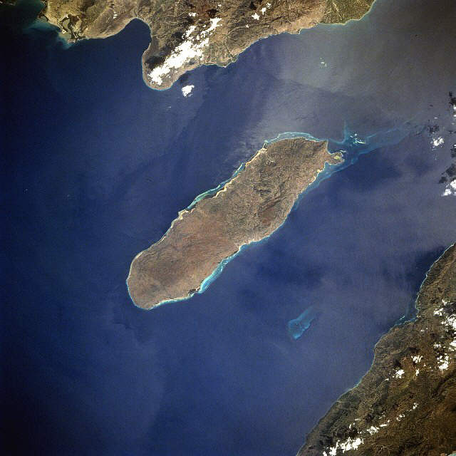
image caption = Satellite view of Gonâve
image size =
locator
Location map|Haiti|lat=18.833333|long=-73.083333
map_custom = yes
native name = Île de la Gonâve
native name link = French language
nickname =
location =Gulf of Gonâve
coordinates = coord|18|50|N|73|05|W|display=inline
archipelago =
total islands =
major islands =
area = convert|743|km2|sqmi|abbr=on
highest mount = unnamed
elevation = convert|778|m|ft|abbr=on
country = Haiti
country admin divisions title = Department
country admin divisions =Ouest Department
country admin divisions title 1 =
country admin divisions 1 =
country admin divisions title 2 =
country admin divisions 2 =
country capital city =
country largest city =Anse-à-Galets
country largest city population = 52,662
country leader title =
country leader name =
population = 100,000
population as of =
density = 134.59
ethnic groups =
additional info =Gonâve Island ( _fr. Île de la Gonâve) is an island of
Haiti located to the west-northwest ofPort-au-Prince in theGulf of Gonâve . It is the largest of the islands in terms of size located off the Hispaniolan mainland. The island is anarrondissement in theOuest Department and includes the communes ofAnse-à-Galets andPointe-à-Raquette . Made up of mostlylimestone , the reef-fringed island of Gonâve is 60 km (37 miles) long and 15 km (9 miles) wide and covers an area of 743 km² (287 sq. miles). The island is mostly barren and hilly with the highest point reaching 778 meters (2,552 ft). The island gets anywhere from 800 mm to 1600 mm of rain a year, higher areas representing the latter figure. Issues of overgrazing and water resource overexploitation affect the island's approximately 100,000 residents. The island was once used as a base forpirates . [ [http://eol.jsc.nasa.gov/sseop/EFS/photoinfo.pl?PHOTO=STS060-84-56 National Aeronautics and Space Administration] ]Water Scarcity
La Gonâve is referred to as one of the most water scarce locations in the world. Residents on the western side of the island are known to walk 12-15 kilometers roundtrip to collect their water that is often brackish.
In 2005 following a particularly drastic drought, the Mayor of Anse Gallets formed the Water Platform, composed of service groups working on the island. Current participants include the Mayors of Anse Gallets and Pointes a Racquette, the Deputy, Justice of the Peace, World Vision, Concern WorldWide, Sevis Kretyen, the Matenwa Learning Center, the Alleghany Weslyen Church, the Methodist Church, [http://www.haitioutreach.org Haiti Outreach] and many others. The Water Platform acts as a focal point for activities on the island, providing a coordination point for the multitude of groups working on La Gonâve.
The members of the Water Platform have been working to address the water needs of the island by capping springs, building rainwater catchment cisterns,building water systems and drilling wells. Dozens of rainwater catchment cisterns and
well s have been drilled on the island as an effort to bring water relief to the poor residents of the island.As of 2007, there are two non-profit groups actively drilling water wells on the island [http://www.haitioutreach.org Haiti Outreach] and [http://www.gutschurch.com Guts Church] .
The [http://www.tougherthanhell.com Tougher Than Hell Motorcycle Rally] , organized by [http://www.gutschurch.com Guts Church] in
Tulsa, Oklahoma has sponsored 8 water wells drilled on the island.[http://www.haitioutreach.org Haiti Outreach] has financed and drilled water wells in 10 communities designated by the Water Platform.
The drilling of more wells on the island has been planned for the near future.
References
Wikimedia Foundation. 2010.