- Štúrovo
Geobox|Settlement
name = Štúrovo
native_name =
other_name = Párkány
category = Town
etymology =
official_name =
motto =
nickname =
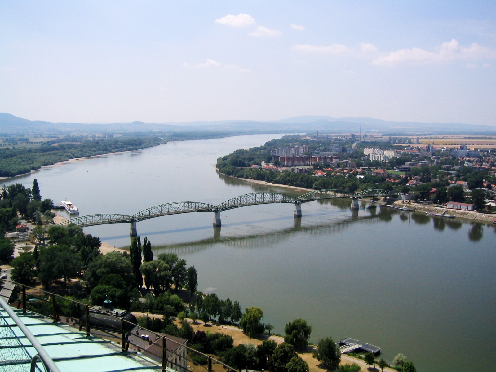
image_caption = Looking towards Štúrovo from theEsztergom Basilica , across the Mária Valéria bridge
symbol =
symbol_type =
country = Slovakia
country_
state =
region = Nitra
district = Nové Zámky
municipality =
landmark =
river = Danube
river1 = Hron
location =
elevation = 111
prominence =
lat_d =47 | lat_m =47 | lat_s =57 | lat_NS =N
long_d =18 | long_m =43 | long_s =05 | long_EW =E
highest =
highest_location = | highest_region = | highest_state =
highest_elevation =
highest_lat_d = | highest_lat_m = | highest_lat_s = | highest_lat_NS =
highest_long_d = | highest_long_m = | highest_long_s = | highest_long_EW =
lowest =
lowest_location = | lowest_region = | lowest_state =
lowest_elevation =
lowest_lat_d = | lowest_lat_m = | lowest_lat_s = | lowest_lat_NS =
lowest_long_d = | lowest_long_m = | lowest_long_s = | lowest_long_EW =
length = | length_orientation =
width = | width_orientation =
area = 13.13
area_land =
area_water =
area_urban =
area_metro =
population =11172 | population_date = 2005-12-31
population_urban =
population_metro =
population_density = auto
population_density_urban =
population_density_metro =
established =1075
established_type = First mentioned
date =
government =
government_location = | government_region = | government_state =
government_elevation =
government_lat_d = | government_lat_m = | government_lat_s = | government_lat_NS =
government_long_d = | government_long_m = | government_long_s = | government_long_EW =
mayor =
leader =
timezone =
map_caption = Location of Štúrovo in Slovakia
map_background = Slovakia - background map.png
map1 = Nitra Region - outline map.svg
map1_caption = Location of Štúrovo in the Nitra Region
map1_background = Nitra Region - background map.png
website = http://www.sturovo.sk
commons = Štúrovo
footnotes =Source: http://www.statistics.sk/mosmis/eng/run.html Municipal Statistics from the Statistical Office of the Slovak republic]Štúrovo ( _hu. Párkány, _tr. Ciğerdelen) is a town in
Slovakia , situated on the River Danube. Its population in 2005 was 11,172/.The town is situated opposite the Hungarian city of
Esztergom . TheMária Valéria bridge connects the settlements. The bridge was destroyed in 1944 during World War II, but reconstructed in 2001.Name
Until 1948, the town was known as "Parkan" in Slovak. It was given its current name after
World War II and is named after the 19th century Slovak national leader,Ľudovít Štúr . There was an attempt to return the old name in a 1991 referendum, however, despite its validity, the government refused to rename the town.http://www.sturovo.sk/main.php?id_menu=17329&id_menu_obsah_m34873=10106&firmy_slovenska_]
History
The town was inhabited in the prehistoric ages, thanks to its favourable location. At one time, it was an important river crossing, and part of the
Limes Romanus system. She had known Avanum during Roman rule. The first written record of Štúrovo was in 1075 under the name "Kakath". In the 16th century, after the Turks conquered Buda in 1541, the town, along with Esztergom, came under the ottoman rule. Many attempts to retake the town from the Turks followed, but they were unsuccessful except 1595–1605 period, until 1683, when the Turks lost a battle near "Parkan". It was renamed as Ciğerdelen ("Liver driller" in Turkish) during Ottoman rule.During the reign of Maria Theresa, the town regained its rights and became a district town.
In 1850, Párkány became a station on the railway track from
Bratislava (known as Pozsony / Pressburg at that time) toBudapest . In 1895, the Mária Valéria bridge to Esztergom was opened .After
World War I , the town became a border town of Czechoslovakia, with only a brief Hungarian occupation in 1919. In 1938, as a result of theFirst Vienna Award , "Parkan" became part of Hungary. It was occupied in the years 1944/1945 by Soviet troops. The Mária Valéria bridge was destroyed for a second time (first time in 1920) by retreating German forces.After
World War II , the town began to industrialize. It was renamed to "Štúrovo" in 1948. The formerly independent villages ofNána andObid were annexed to Štúrovo (in 1960 and 1972, respectively). Štúrovo ceased to be a district in 1960 and merged intoNové Zámky District . The biggest factory called "Juhoslovenské celulózky a papierne" (South Slovakian pulpwood and paper works) was opened in 1968, employing some 4,000 people. A new thermal swimming resort "Vadaš" was built in 1978. The local railway station became the second biggest in Slovakia (1975).After the
Velvet Revolution , Nána (1990) and Obid (1998) became separate villages again and the Mária Valéria bridge was opened for the third time in 2001, boosting the local economy.Demographics
According to the 2001 census, there were 11,708 people living in Štúrovo, with 68.7% of the inhabitants being ethnic Hungarian, as opposed to 28.1% ethnic Slovak. The religious make-up was as follows: Roman Catholic 77.18%, without denomination or not specified 16.45%, Evangelic 1.36%.
Partner towns
*
Esztergom , Hungary
*Bruntál , Czech Republic
*Castellarano , Italy
*Baraolt , Romania
*Novi Bečej , Serbia
*Klobuck , PolandReferences
External links
* [http://www.sturovo.sk Official website] sk icon, hu icon, en icon
* [http://vadas.sk/index.php?lang=english Thermal swimming resort Vadaš]


Wikimedia Foundation. 2010.