- Bingley (ward)
-
Coordinates: 53°51′03″N 1°50′17″W / 53.8509°N 1.8380°W
Bingley 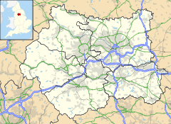
 Bingley
Bingley shown within West YorkshirePopulation 15,925 OS grid reference SE106394 Metropolitan borough City of Bradford Metropolitan county West Yorkshire Region Yorkshire and the Humber Country England Sovereign state United Kingdom Post town BRADFORD Postcode district BD16 Dialling code 01274 Police West Yorkshire Fire West Yorkshire Ambulance Yorkshire EU Parliament Yorkshire and the Humber UK Parliament Shipley List of places: UK • England • Yorkshire Ward Name: Bingley Councillor: Colin Mathew Gill Party: Conservative Party Councillor: David Heseltine Party: Conservative Party Councillor: Robin Ernest Owens Party: Conservative Party Bingley (population 15,925 - 2001 UK census) is a Ward in Bradford Metropolitan District in the county of West Yorkshire, England, named after the town of Bingley around which it is centred.
As well as the town of Bingley the ward includes the conurbated villages of Eldwick, Gilstead, the slightly detached village of Micklethwaite and part of Crossflatts (the rest of which is located in Keighley East). The ward also extends to cover a substantial section of the moorland above the town.
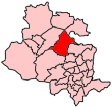 2004 Boundaries of Bingley Ward
References
- BCSP (Internet Explorer only)
- BBC election results
- Council ward profile (pdf)
Categories:- Wards of Bradford
- Bingley
- West Yorkshire geography stubs


Wikimedia Foundation. 2010.