- Obruchev (crater)
-
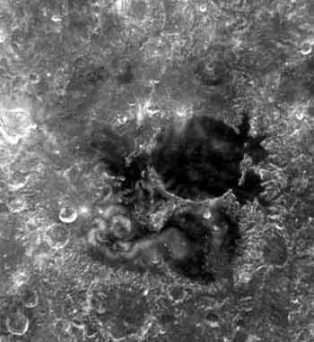
Obruchev (crater) 
Mare Ingenii, with Obruchev to the south.Coordinates 38°54′S 162°06′E / 38.9°S 162.1°ECoordinates: 38°54′S 162°06′E / 38.9°S 162.1°E Diameter 71 km Depth Unknown Colongitude 198° at sunrise Eponym Vladimir A. Obruchev Obruchev is a disintegrating lunar crater that lies along the southern shore of Mare Ingenii, on the far side of the Moon. Less than three crater diameters to the south of Obruchev is the crater Chrétien, and about the same distance to the southeast lies Oresme.
The outer rim of this crater has been heavily damaged and now forms an irregular, rugged ring about the interior. The crater partly overlies the satellite crater Obruchev M to the south, and there is a pair of smaller craters along the western rim and inner wall. The interior of Obruchev has some uneven edges, but it is relatively level and featureless nearer the center.
Satellite craters
By convention these features are identified on lunar maps by placing the letter on the side of the crater mid-point that is closest to Obruchev.
Obruchev Latitude Longitude Diameter M 40.5° S 162.2° E 46 km T 38.5° S 157.7° E 21 km V 36.6° S 158.3° E 39 km X 34.7° S 159.5° E 18 km References
- Andersson, L. E.; Whitaker, E. A., (1982). NASA Catalogue of Lunar Nomenclature. NASA RP-1097.
- Blue, Jennifer (July 25, 2007). "Gazetteer of Planetary Nomenclature". USGS. http://planetarynames.wr.usgs.gov/. Retrieved 2007-08-05.
- Bussey, B.; Spudis, P. (2004). The Clementine Atlas of the Moon. New York: Cambridge University Press. ISBN 0-521-81528-2.
- Cocks, Elijah E.; Cocks, Josiah C. (1995). Who's Who on the Moon: A Biographical Dictionary of Lunar Nomenclature. Tudor Publishers. ISBN 0-936389-27-3.
- McDowell, Jonathan (July 15, 2007). "Lunar Nomenclature". Jonathan's Space Report. http://host.planet4589.org/astro/lunar/. Retrieved 2007-10-24.
- Menzel, D. H.; Minnaert, M.; Levin, B.; Dollfus, A.; Bell, B. (1971). "Report on Lunar Nomenclature by the Working Group of Commission 17 of the IAU". Space Science Reviews 12 (2): 136–186. Bibcode 1971SSRv...12..136M. doi:10.1007/BF00171763.
- Moore, Patrick (2001). On the Moon. Sterling Publishing Co. ISBN 0-304-35469-4.
- Price, Fred W. (1988). The Moon Observer's Handbook. Cambridge University Press. ISBN 0-521-33500-0.
- Rükl, Antonín (1990). Atlas of the Moon. Kalmbach Books. ISBN 0-913135-17-8.
- Webb, Rev. T. W. (1962). Celestial Objects for Common Telescopes (6th revision ed.). Dover. ISBN 0-486-20917-2.
- Whitaker, Ewen A. (1999). Mapping and Naming the Moon. Cambridge University Press. ISBN 0-521-62248-4.
- Wlasuk, Peter T. (2000). Observing the Moon. Springer. ISBN 1-85233-193-3.
Categories:- LQ29 quadrangle
- Impact craters on the Moon
- Lunar crater stubs
Wikimedia Foundation. 2010.