- Barclayville
Infobox Settlement
official_name = Barclayville
other_name =
native_name =
nickname =
settlement_type =
motto =
imagesize = 300px
image_caption =
flag_size =
image_
seal_size =
image_shield =
shield_size =
image_blank_emblem =
blank_emblem_type =
blank_emblem_size =
mapsize =
map_caption =
mapsize1 =
map_caption1 =
image_dot_
dot_mapsize =
dot_map_caption =
dot_x = |dot_y =
pushpin_
pushpin_label_position =bottom
pushpin_map_caption =Location in Liberia
subdivision_type = Country
subdivision_name =
subdivision_type1 = County
subdivision_name1 =Grand Kru County
subdivision_type2 = District
subdivision_name2 =
subdivision_type3 =
subdivision_name3 =
subdivision_type4 =
subdivision_name4 =
government_footnotes =
government_type =
leader_title =
leader_name =
leader_title1 =
leader_name1 =
leader_title2 =
leader_name2 =
leader_title3 =
leader_name3 =
leader_title4 =
leader_name4 =
established_title =
established_date =
established_title2 =
established_date2 =
established_title3 =
established_date3 =
area_magnitude =
unit_pref =Imperial
area_footnotes =
area_total_km2 =
area_land_km2 =
area_water_km2 =
area_total_sq_mi =
area_land_sq_mi =
area_water_sq_mi =
area_water_percent =
area_urban_km2 =
area_urban_sq_mi =
area_metro_km2 =
area_metro_sq_mi =
area_blank1_title =
area_blank1_km2 =
area_blank1_sq_mi =
population_as_of =
population_footnotes =
population_note =
population_total =
population_density_km2 =
population_density_sq_mi =
population_metro =
population_density_metro_km2 =
population_density_metro_sq_mi =
population_urban =
population_density_urban_km2 =
population_density_urban_sq_mi =
population_blank1_title =Ethnicities
population_blank1 =
population_blank2_title =Religions
population_blank2 =
population_density_blank1_km2 =
population_density_blank1_sq_mi =
timezone =
utc_offset =
timezone_DST =
utc_offset_DST =
latd=4 |latm=40 |lats=47 |latNS=N
longd=8|longm=14|longs= 2|longEW=W
elevation_footnotes =
elevation_m =
elevation_ft =
postal_code_type =
postal_code =
area_code =
blank_name =
blank_info =
blank1_name =
blank1_info =
website =
footnotes =Barclayville, the capital and most populous settlement in
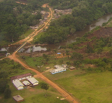
Grand Kru County is located in southeasternLiberia about 10 miles inland fromPicinicess . The Barclayville township of several thousand people straddles the banks of theNa River . Roads fromKanweaken to the northwest,Pleebo to the southeast, and to Picinicess andGrand Cess to the southeast, all intersect at Barclayville. In March 2006 the United Nations reported completion of the Na River bridge at Barclayville, connecting theKanweaken andPleebo roads for the first time.The modern jurisdiction of Barclayville was created by President Barclay in response to the last Kru Wars in the 1930s. As part of the effort to exert central government authority and diminish inter-tribal conflicts that resulted in devastation, four separate villages were combined into one township. Until the creation of Barclayville, the constituent villages of
Seetor andKayken , which are from rival chiefdoms, were in periodic conflict. The villages of Seetor, Kayeken andWakpeken and their "suburbs " are on the northwest side of the Na river whileTopor is on the opposite bank across from Wakpekan. Despite the town's large size, most structures are traditional mud and stick homes and(as of mid 1980) few have running water orelectricity . Kplio (a dialect of Grebo) is the primary language of all Barclayvillians but English is the official language of instruction.The regional
high school is in Barclayville along with several public and private (Christian) schools for grades K-8. Many religious denominations havechurches and/or missions in Barclayville includingMethodist ,Baptist ,Catholic , and a variety of evangelical congregations, though most of the population also follows local animist practices. Prior to theLiberian Civil War much of the male adult population were on government payroll employed as teachers, employees of the courts, or serving as government officials or their staff. Nevertheless, uplandrice farming is the primary occupation. Each village lays claim to large areas of land that extend several miles inland from the town upon which they doslash and burn farming , rotating to a new section of land every year. Because of the distance from the farms to the villages it is common for the women and younger children to live on the farms during the growing season where they establish vegetable gardens and plantcassava . Farming within Barclayville is limited by the presence of freely roaminglivestock andfowl includingcows ,sheep ,goats andchickens .[Disclaimer: This information predates the Liberian civil war]
In June 2005 the UN Integrated Regional Information Regional Network reported that the roads leading to Barclayville had decayed and become overgrown by dense bush rendering them impassable.
References
Wikimedia Foundation. 2010.

