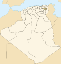
- Ouled Hamla
-
Ouled Hamla (In Arabic أولاد حملة) is a town located in Daira of Ain M'lila - Wilaya d Oum El Bouaghi - Algeria.
Bordered on the north-west by the municipality of Teleghma (wilaya of Mila), the Commune Souk Naaman south-west by the municipality of Khroub (wilaya of Constantine) to North-east, and by Ain M'lila south-east. The commune of Ouled Hamla covers an area of 152 km ². The population is estimated at 11,546 inhabitants, or a density of 75.96 inhabitants km2.
The main crops have been maintained over the centuries, including ereal, including wheat and barley. Other important agricultural products include potato, tomato, pepper, carrot ... etc.
Etymology
The old name of Ouled Hamla was Bertaux, the word indicates a name of a French colonel who lived in Ouled Hamla during the French colonization.
Coordinates: 36°05′N 6°28′E / 36.083°N 6.467°E
Capital: Oum El BouaghiDistricts · Aïn Babouche · Aïn Beïda · Aïn Fakroun · Aïn Kechra · Aïn M'Lila · Dhalaâ · F'Kirina · Ksar Sbahi · Meskiana · Oum El Bouaghi · Sigus · Souk Naâmane
Communes · Oum el Bouaghi · Aïn Babouche · Aïn Beida · Aïn Diss · Aïn Fakroun · Aïn Kercha · Aïn M'lila · Aïn Zitoun · Behir Chergui · Berriche · Bir Chouhada · D'hala · El Amiria · El Belala · El Djazia · El Fedjouz Boughrara Saoudi · El Harmilia · Fkirina · Hanchir Toumghani · Ksar Sbahi · Meskiana · Oued Nini · Ouled Gacem · Ouled Hamla · Ouled Zoual · Rahia · Sigus · Souk Naamane · ZorgCategories:- Populated places in Oum El Bouaghi Province
- Communes of Algeria
Wikimedia Foundation. 2010.
