Oban Hydro

Oban Hydro
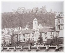
The Hydro pictured from Oban in 1897

The Oban Hills Hydropathic Sanatorium was a proposed Hydropathic Hotel in Oban, Scotland. Construction of the hotel began in 1881 on a hill east of the downtown overlooking the town and the harbour. Had it been completed the hotel would have been a major landmark on the Oban skyline. The hotel was never completed due to financial difficulties and currently lies in ruins.

History

Hydropathy, the use of water for treating diseases and soothing pains, was very popular amongst the wealthy in 19th century Britain, with several Hydropathic Hotels being built around Scotland. With the newly arrived railway making Oban accessible to Glasgow and Edinburgh a group of Glasgow businessmen formed the Oban Hills Hydropathic Sanatorium Limited in 1881. The proposed hotel was to have contained 137 bedrooms, a conservatory, a concert hall and seawater baths. There were also plans for a golf course, stables, landscaped gardens and a hydraulic lift to bring guests up from the town.

Robert MacAlpine and Co. was contracted for the construction and 300 workers were employed in building the hotel. A miniature railway was built to carry construction materials up the hill. By 1882 the roof timbers were in place and the hotel was distinctly visible from the town below.

However, the project soon fell into financial difficulty, the cost of the hotel having been grossly underestimated.[1] Shareholders were unwilling to continue financing the construction and the nearly-completed hotel was abandoned. The structure slowly fell into ruin as local residents pillaged stones to build their own homes. The Old Hydro is now barely visible from the town below.

References

Oban War and Peace Museum. Exhibit: "The Oban Hills Hydropathic Sanatorium", 2009.

  1. ^ John Paterson (2006). "The Hydro". http://www.obanargyll.com/hydro.html. Retrieved 2009-11-18. 

Coordinates: 56°24′44″N 5°28′03″W / 56.41218°N 5.46763°W / 56.41218; -5.46763


Wikimedia Foundation. 2010.

Игры ⚽ Нужна курсовая?

Look at other dictionaries:

  • Oban — For other uses, see Oban (disambiguation). Coordinates: 56°24′44″N 5°28′13″W / 56.412356°N 5.470232°W / 56.412356; 5.470232 …   Wikipedia

  • Falls of Cruachan railway station — Infobox UK station name = Falls of Cruachan other name = Easa Chruachain code = FOC caption = manager = First ScotRail locale = Cruachan borough = Argyll and Bute latitude = longitude = lowusage0405 = 124 lowusage0506 = 108 lowusage0607 = 154… …   Wikipedia

  • Lochearnhead, St Fillans and Comrie Railway — [v · d · …   Wikipedia

  • Argyll and Bute — Pour les articles homonymes, voir Argyll (Écosse) et Île de Bute. Argyll and Bute Géogr …   Wikipédia en Français

  • List of museums in Scotland — This list of museums in Scotland contains museums which are defined for this context as institutions (including nonprofit organizations, government entities, and private businesses) that collect and care for objects of cultural, artistic,… …   Wikipedia

  • Glasgow Mid Argyll — Full name Glasgow Mid Argyll Shinty Club Gaelic name Comann Camanachd Ghlaschu Meadhain Earra ghaidheal Nickname GMA Founded 1928 …   Wikipedia

  • Interlocking — In railway signaling, an interlocking is an arrangement of signal apparatus that prevents conflicting movements through an arrangement of tracks such as junctions or crossings. The signaling appliances and tracks are sometimes collectively… …   Wikipedia

  • Scottish Highlands — The Scottish Highlands (Scottish Gaelic: A Ghàidhealtachd , Scots: Hielans ) include the rugged and mountainous regions of Scotland north and west of the Highland Boundary Fault, although the exact boundaries are not clearly defined, particularly …   Wikipedia

  • Bridge of Awe — Bridge of Awe, near Taynuilt in Argyll, Scotland, is also known as Drochaid Abha .The original Bridge of Awe was a three arch bridge. When the bridge was originally constructed, the work began in a very dry season and all was going well until a… …   Wikipedia

  • River Tay — Infobox River | river name = River Tay |200px caption = Looking upstream (north) along the Tay from the centre of Perth origin = Loch Tay mouth = Firth of Tay basin countries = Scotland length = 120 miles (193 km) elevation = discharge = 170 m³/s …   Wikipedia

Share the article and excerpts

Direct link
Do a right-click on the link above
and select “Copy Link”