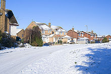
Oakley Vale

Oakley Vale
Oakley Vale in snow

Oakley Vale is a 436-acre (1.76 km2) housing development situated in the south west of Corby, England. The development was begun in 2001 by Cofton, and over 2000 houses have now been built. The adjacent area of Snatchill, developed from around the mid-1990s, is often regarded as being within the Oakley Vale development boundary.

Oakley Vale contains a mix of housing types ranging from small apartments to large 5 or six bedroomed family homes. The cost of housing at levels lower than the UK average and the proximity to the East Midlands main line have attracted homebuyers from more expensive surrounding areas and even as far afield as London.

Local services in Oakley Vale include Morrisons and a parade of shops at Charter Court on Butland Road. This parade includes a Tesco, a number of fast food outlets, an estate agency as well as a Dentist and a Pharmacy. Oakley Vale Primary school was opened in 2008 and Brooke Weston College, one of the UK's best state schools, is located in the Oakley Vale development

Located in the south west of Corby, Oakley vale is within a few minutes of the A14 road (England) and just 23 miles (38 km) of the UK motorway network via the M1 motorway (Great Britain) and the M6 motorway The development is 2 miles (3 km) from Corby railway station providing fast links to London St Pancras station.

References

[1] Brooke Weston College

Coordinates: 52°28′N 0°43′W / 52.47°N 0.71°W / 52.47; -0.71


Wikimedia Foundation. 2010.

Игры ⚽ Нужен реферат?

Look at other dictionaries:

  • Oakley, Buckinghamshire — Coordinates: 51°48′14″N 1°04′19″W / 51.804°N 1.072°W / 51.804; 1.072 …   Wikipedia

  • Oakley (Buckinghamshire) — Pour les articles homonymes, voir Oakley. 51° 48′ 14″ N 1° 04′ 19″ W / …   Wikipédia en Français

  • Aylesbury Vale — 51° 53′ 28″ N 0° 54′ 43″ W / 51.891, 0.912 Aylesbury Vale …   Wikipédia en Français

  • Wrington Vale Light Railway — The Wrington Vale Light Railway was a railway from Congresbury on the Cheddar Valley Line to Blagdon, and serving villages in the Yeo Valley, North Somerset. Construction of the line started in 1897 and it opened in 1901. Passenger services… …   Wikipedia

  • Corby Borough Council elections, 2007 — Elections for Corby Borough Council, which covers the Borough of Corby, were held on 3 May 2007. Labour retained overall control of the council. There had been a number of boundary changes since the 2003 elections. The overall results, using… …   Wikipedia

  • Stagecoach in Northants — Stagecoach Northants Founded Connect Kettering (March 2006) Connect Wellingborough (October 2006) Headquarters Northampton, Northamptonshire Service area All Nort …   Wikipedia

  • Corby — For other uses, see Corby (disambiguation). Borough of Corby   Town Borough   Corby town centre skyline, seen from Oakley Woods …   Wikipedia

  • Corby local elections — Corby Council is elected every four years. Contents 1 Political control 2 Council elections 3 By election results 4 External links …   Wikipedia

  • University of Birmingham — Infobox University name = University of Birmingham image size = 234px motto = la. Per Ardua Ad Alta mottoeng = Through hard work, great heights are achieved established = 1825, with Royal Charter granted in 1900 city = Birmingham state = West… …   Wikipedia

  • Brill — infobox UK place country = England latitude= 51.8204 longitude= 1.0515 official name= Brill population = 1,190 [ [http://www.neighbourhood.statistics.gov.uk/dissemination/LeadTableView.do?a=7 b=792019 c=brill d=16 e=15 g=424069 i=1001x1003x1004 m …   Wikipedia

Share the article and excerpts

Direct link
Do a right-click on the link above
and select “Copy Link”