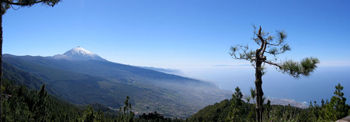
- Orotava Valley
-
The greenish and fruitful Orotava Valley (Spanish: Valle de la Orotava) is a beautiful valley filled with gullies and cliffs located in the northern part of the Canary island of Tenerife, in Spain. The valley is 10 by 11 km.
 Oratova Valley, view towards Pico de Teide
The valley stretches from the sea up to the mountains at 2,000 m which begins near Las Cañadas up to Pico del Teide at 3,718 m is Spain's tallest mountain. The valley includes the municipalities of Los Realejos, Puerto de la Cruz and La Orotava. The valley is also a park area.
The valley in the era of the Guanches was known as Taoro until the final conquest July 28, 1496. The mencey of Taoro agreed to the release of the hostilities by Alonso Fernández de Lugo (1456-1525).
The valley is situated in the tectonic zone.
The superhighway cuts through the valley and has several interchanges as well.
Places and Tourism
The name of the valley is the traditional and a representative city of La Orotava is located at 340 m above sea level with about 38,000 people. Puerto de la Cruz is a small place of La Orotava, the old main port in the valley and a tourist area in northern Tenerife.
Coordinates: 28°23′15″N 16°32′43″W / 28.38747°N 16.54541°W
Categories:
Wikimedia Foundation. 2010.
