North Ridge, Accra

North Ridge, Accra
North Ridge District
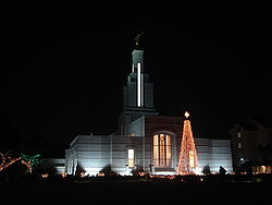
Church of Jesus Christ of Latter Day Saints Temple
Location: Roughly:
W: Kanda highway
S: Castle Road
N: Ring Road East
E: Independence Avenue
Governing body: Accra Metropolitan Assembly

North Ridge is a district of Accra, Ghana bounded to the south by Castle Road. The Kanda highway serves as the district's western boundary, while the Independence Avenue/Liberation Avenue is the eastern boundary. The Ring road separates North Ridge from the northern district of Kanda. The headquarters of the Bureau of National Investigations is located in North Ridge. Originally planned as a neighborhood for civil servants and businessmen in the colonial era, North Ridge remains one of the better residential neighborhoods in Accra.[1].

The area of North Ridge, West Ridge, and East Ridge is collectively referred to as "The Ridge." This area is populated by several major embassies, including those of Germany and the United Kingdom. In addition, several of Accra’s upmarket hotels, and several Ghanaian administrative offices are located in this district.

Landmarks/Places of Interest

References


Wikimedia Foundation. 2010.

Игры ⚽ Поможем сделать НИР

Look at other dictionaries:

  • Accra — Accra …   Deutsch Wikipedia

  • Accra Métropole — Accra métropolitain Accra métropolitain Pays Ghana Région Grand Accra Catégorie de District Métropolitain Gouverneur Alfred Vanderpuije …   Wikipédia en Français

  • Accra metropole — Accra métropolitain Accra métropolitain Pays Ghana Région Grand Accra Catégorie de District Métropolitain Gouverneur Alfred Vanderpuije …   Wikipédia en Français

  • Accra métropole — Accra métropolitain Accra métropolitain Pays Ghana Région Grand Accra Catégorie de District Métropolitain Gouverneur Alfred Vanderpuije …   Wikipédia en Français

  • Accra métropolitain — 5°33′N 0°13′W / 5.55, 0.217 …   Wikipédia en Français

  • Neighborhoods of Accra — Map showing the location of Accra s neighborhoods The city of Accra is officially divided into four geographical regions North, West, East, Central and eleven sub metropolitan areas: Osu Klottey, Ablekuma North, Ablekuma South, Ayawaso Central,… …   Wikipedia

  • Templo de Accra — Tipo Templo Ubicación …   Wikipedia Español

  • List of schools in Ghana — A list of schools in Ghana. NOTOC A*Action Secondary Technical School [http://www.actionschool.net Website] *Ada Secondary School *A.M.A Anne Health Academys *Abandze Methodist Primary *Abassador International Junior Secondary School *Abetifi… …   Wikipedia

  • Akkra — Dieser Artikel oder Abschnitt ist nicht hinreichend mit Belegen (Literatur, Webseiten oder Einzelnachweisen) versehen. Die fraglichen Angaben werden daher möglicherweise demnächst gelöscht. Hilf Wikipedia, indem du die Angaben recherchierst und… …   Deutsch Wikipedia

  • Tabom people — The Tabom People refers to the Afro Brazilian community in Accra. The Tabom People is an Afro Brazilian community of former slaves. When they arrived in Accra they could speak only Portuguese, so they greeted each other with “Como esta?” (How are …   Wikipedia

Share the article and excerpts

Direct link
Do a right-click on the link above
and select “Copy Link”