- Street of the Prophets
-
 Street sign from the British Mandate era.
Street of the Prophets (Hebrew: רחוב הנביאים, Rehov HaNevi'im) is an east-west axis road in Jerusalem beginning outside Damascus Gate and ending at Davidka Square. Located to the north of Jaffa Road, it bisects the neighborhood of Musrara.
During its heyday in the late 19th century and early 20th century, Street of the Prophets was a favorite address for hospitals, churches, monasteries, hospices,[1] government offices, foreign consulates, and wealthy Christian, Jewish and Arab residents.
Today the street still boasts the same heterogeneous mix of residents and workers,[2] as well as schools, hospitals, churches and government offices. The elegant 19th-century architecture gives Street of the Prophets the appellation of "most beautiful street outside the Old City", while its historic buildings make it the most popular site for guided tours outside the Old City.[2]
Contents
History
Name
 The Italian Hospital (left) overlooking the neighborhood of Musrara, circa 1950.
Street of the Prophets was established during the expansion of Jerusalem beyond the walls of the Old City in the mid-19th century.[3] In the beginning, the street did not have a name. It was known as:
- "Street of the Hospitals" — due to the many hospitals, Christian and Jewish, situated along its route;
- "Street of the Consuls" — due to the many foreign consulates that opened offices here.[3][4]
The street was officially named at the beginning of the British Mandate period by the Governor of Jerusalem, Ronald Storrs.[3] At that time, the street was paved and infrastructure for water and electricity were installed.
According to one opinion, the street was named for the prophets of Israel, many of whom prophesied in Jerusalem.[4] Another opinion holds that the street was named for the prophets of Judaism, Christianity and Islam, since the Mamluk tomb of Nabi Okasha in the nearby Zikhron Moshe neighborhood was traditionally viewed as the burial site of prophets of the three monotheistic faiths.[3]
Hospitals
 The English Mission Hospital, today part of the Anglican International School campus.
Early on, Street of the Prophets was a popular address for hospitals. In the mid-19th century, the hospitals that were located in the Old City were forced to move due to high population density and difficult sanitary conditions. Each hospital re-established itself on Street of the Prophets to maintain its proximity to the Jewish residents still residing in the Old City.
The hospitals run by Christian missionary organizations offered free medical care to attract Jewish patients for the purposes of missionizing. This practice was decried by the rabbis of the era, who issued a cherem against Jews who used these health services. Despite rabbinical opposition, many Jews continued to turn to Christian missionary hospitals for medical care.[5]
 Garden view of Meyer Rothschild Hospital.
The hospitals established on Street of the Prophets in the late 19th century and early 20th century included:
- A sanitarium operated by the London Society for Promoting Christianity Among the Jews (#82), built in 1862
- Marienstift Children's Hospital, opened in 1872 by Dr. Max Sandreczky (#29)
 Close-up of original door plate.
- Meyer Rothschild Hospital, the first Jewish hospital outside the Old City, built by Baron James Rothschild in 1888 and named after his father (#37)
- German Deaconess Hospital, opened in 1894 (#49)
- English Mission Hospital, opened in 1897 (#82)
- Bikur Holim Hospital, built in 1910 (#53)
- Italian Hospital, opened in 1919 (#34)
Government offices and consulates
- The Pasha's Village (#61) was built by the Greek Orthodox Church and rented out to the Ottoman governors of Jerusalem.[6]
- The German consulate once stood beside the International Evangelical Church on the site of present-day Raoul Wallenberg Street. It was attacked by the Israeli underground when it flew a flag with a swastika in 1933,[7] and was subsequently destroyed by the underground.[8]
- The U.S. Consulate General, founded in the Old City in 1844, relocated to an address near the beginning of Street of the Prophets in the late 19th century. In 1912, it moved to its present address on Agron Street.[9]
- The Ethiopian consulate building (#38-40) was constructed by Empress Zewditu I of Ethiopia in 1928;[10] it housed that country's consulate from 1948-1973.[11]
Christian missions
Street of the Prophets was also home to Christian missions. The most prominent was the London Jews' Society mission headquartered at the western end of the street (now the Anglican International School campus). This 32-dunam site housed and employed hundreds of impoverished Jewish immigrants from Russia in the 1880s.[10]
Hotels
 Present-day exterior of the Kaminitz Hotel.
- The Kaminitz Hotel (#65), constructed in 1878, was a five-star hotel with a carriage entrance from Jaffa Road.[6]
- The San Remo Hotel (#70) erected in 1927, occupied the three-story building on the northeast corner of Street of the Prophets and Straus Street, opposite Bikur Holim Hospital.[10]
Notable residents
 Tabor House, home of architect Conrad Schick.
Unlike other areas outside the Old City which were exclusively Jewish, Christian or Arab, the Street of the Prophets was a heterogeneous zone. Ottoman and, later, British officials; foreign consuls and well-to-do residents all lived here, creating a cultural and social center.[12]
Notable residents who lived on the street include:
- Conrad Schick, German Protestant missionary and architect who constructed several of the buildings on the street (see next section), including his own home, which he called "Tabor House" (#58).
- William Holman Hunt, English painter, who constructed his own home at #64 in 1869; the home was subsequently occupied by Dr. Helena Kagan, Jerusalem's first pediatrician. Hebrew poetess Rachel Bluwstein lived in the small white house in the courtyard in 1925.[13]
- Joseph Navon, a Jewish businessman and initiator of the Jaffa–Jerusalem railway, owner of the Navon Bey House (#59).[6]
 Mahanaim House.
- Johannes Frutiger, a Swiss banker who named his home, built in 1885, Mahanaim after the verse in Genesis 32:2. His family was later forced to sell the mansion on the corner of Street of the Prophets and Shivtei Yisrael Street; it was later occupied, in turn, by the Evelina de Rothschild School,[8] Menachem Ussishkin, director of the Jewish National Fund,[10] and Lord Herbert Plumer, High Commissioner during the Mandate period.[14] Today it houses offices of the Israeli Ministry of Education.
Communities
In the late 19th century, several Jewish neighborhoods were founded at the eastern end of Street of the Prophets, near Damascus Gate. Kiriyah Ne'emana (also known as Battei Nissan Beck), founded in 1879, housed Hasidic and Sephardi families;[5] Eshel Avraham was established in 1893 by Georgian Jews; and Chatzer Strauss was founded in 1896 by Rabbi Shmuel Strauss for Ashkenazi families.[5]
Beginning in the 1880s, an Ethiopian Christian community developed around the Ethiopian Church of Debre Gannet (Mount of Paradise) located on a site in Ethiopia Street bought in 1888, just north of Street of the Prophets.[15] Under the initiative of Empress Taytu Betul, Ethiopian nobles and wealthy individuals contributed large sums of money to purchase houses on Ethiopia Street and Street of the Prophets, which belong to the community to this day.[11]
Architecture
 Typical house and garden fronted by a high stone wall.
Most of the buildings on Street of the Prophets are constructed of stone and fronted by high walls built of stone and mortar. Private-home lots are large and include garden courtyards, either in front of the building (e.g. Hunt House, Navon Bey House, Mahanaim House) or behind it (e.g. Pasha's Village). The homes are one or two stories high; public buildings do not exceed four stories.
European influence
 Nighttime exterior of the German Hospital, today Bikur Holim Hospital.
Many public and private buildings on the western side of Street of the Prophets, from Shivtei Israel Street to Davidka Square, are constructed in the European style and reflect the nationality of their builders. For example, the German Deaconess Hospital and its bell tower (today the eastern wing of Bikur Holim Hospital) are typical of public buildings in Germany. Buildings and doors along the street are decorated with religious symbols such as crosses, Stars of David, crescents, symbols of religious orders, and Bible verses.
Several buildings were designed by architect Conrad Schick: the mission of the London Jews' Society (today the Anglican International School); the German hospital,[10] and the Tabor House (today the Swedish Theological Institute) (#58), which Schick made into his own home. Schick planned the William Holman Hunt House (#64), which Hunt himself built.
The Renaissance-style Italian Hospital was designed by Antonio Barluzzi, who created several other Christian churches in Jerusalem. It was completed in 1919; today it houses the Israel Ministry of Education and Culture.[10]
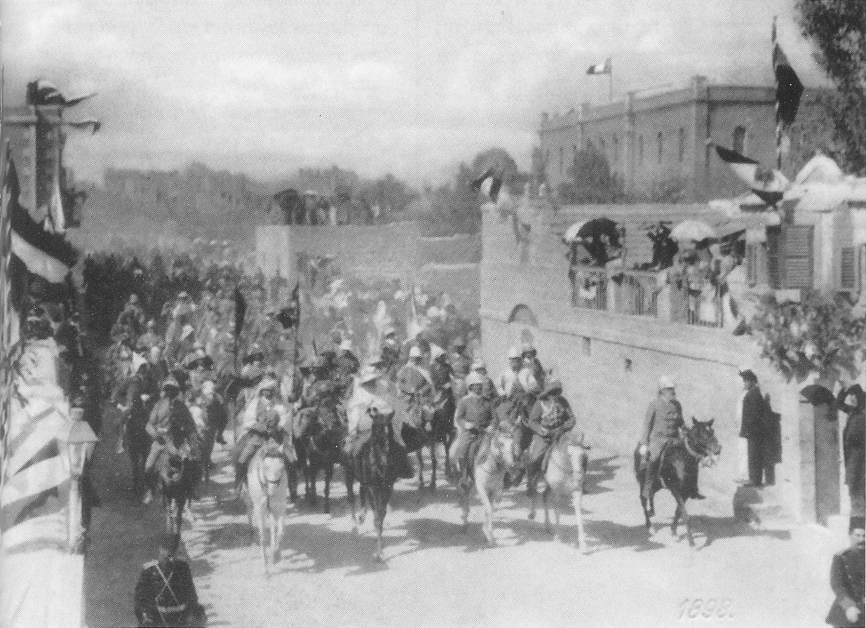
 Procession of Emperor Wilhelm II in the Street of the Prophets, October 29, 1898. Tabor House is at right.
In 1898, Theodor Herzl came to Jerusalem for the first time to meet with German emperor Wilhelm II, who was also visiting this city. Herzl met the emperor on an empty lot at #42 Street of the Prophets, where Wilhelm and his entourage were quartered in a tent camp.[10] Herzl's efforts to plead the Zionist cause with the emperor were unsuccessful.[16] Following the emperor's visit, the Ottoman authorities gave him the lot as a gift; Wilhelm, in turn, granted it to the German provostry, which constructed its headquarters there in 1903.[14] Today the former provostry is part of the Jerusalem ORT campus.[10]
African influence
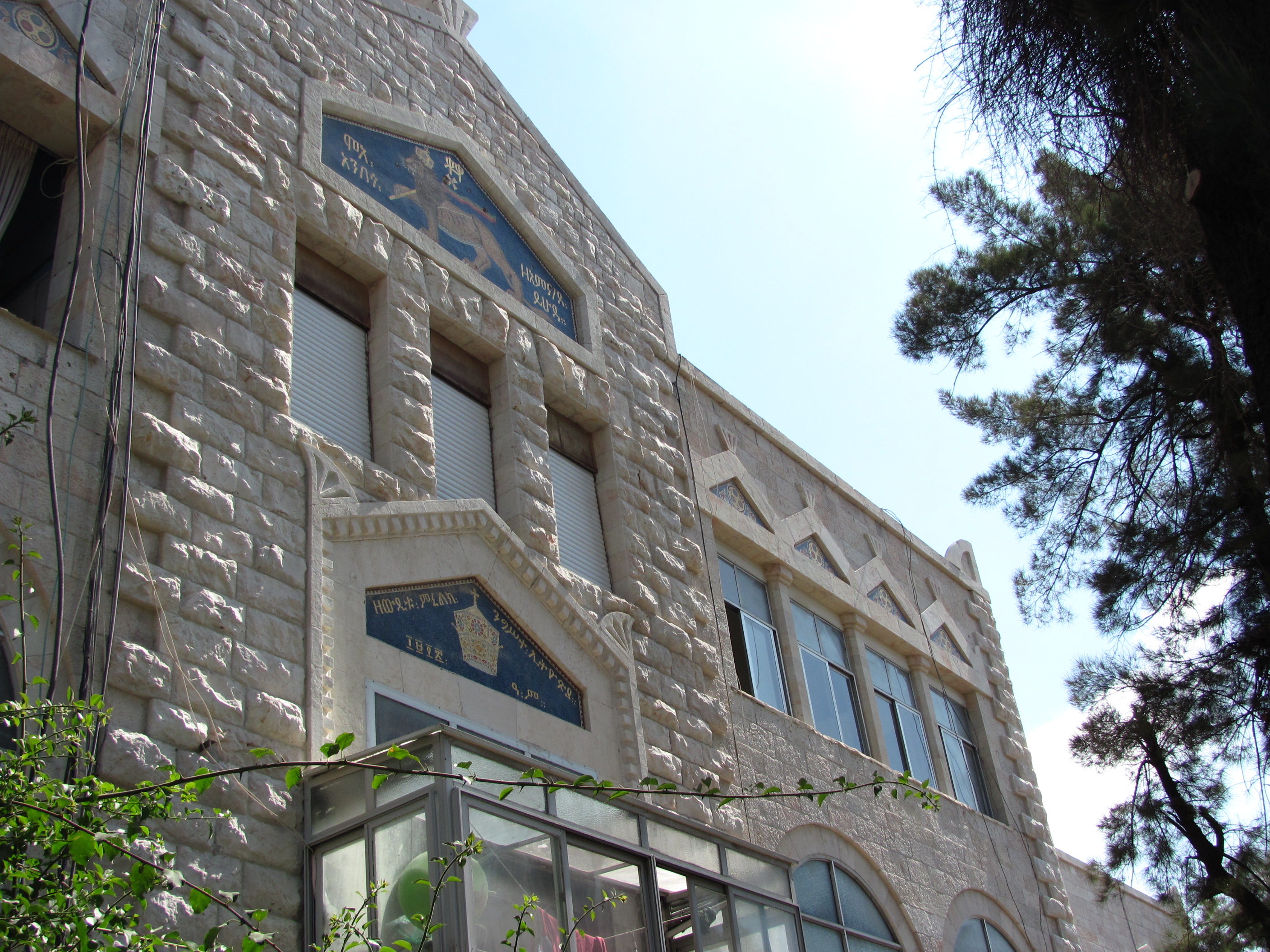
 Ethiopian consulate building.
The former Ethiopian consulate building at #38 and #40 is the sole representative of African architecture. The land for the building was purchased in 1910 by Baron von Ustinov on the directive of Empress Taytu of Ethiopia; his widow, Magdalena, sold the property and the partially-finished building to Empress Zauditu in 1924.[17] The white stone structure, completed in 1928, has gabled windows decorated with bright blue and gold porcelain mosaics. The largest mosaic depicts a lion bearing a cross and flag — the symbol of the Ethiopian royal family — with the inscription in Ge'ez: "The Lion of Judah Triumphs".[11] Today the building is an apartment complex.[11]
Arabic influence
 A hostel on the Arab side of Street of the Prophets.
In contrast to the buildings on the western side of Street of the Prophets, the style of architecture on the eastern side, from Damascus Gate to Shivtei Israel Street, is distinctly Middle Eastern. The section from Damascus Gate to Highway 60 is solely inhabited by Palestinians and is part of East Jerusalem. It is a major shopping area for Arab residents, with many grocery stores and restaurants lining the street.
Homes in the Musrara district (between Highway 60 and Shivtei Israel Street) were constructed by wealthy Arabs in the late 19th century and early 20th century . These Arabs fled or were expelled from the area during the 1948 Arab-Israeli War and were not permitted return to their homes after Israel was declared a Jewish state. Today Musrara is a Jewish neighborhood.[18]
Armenian mosaic
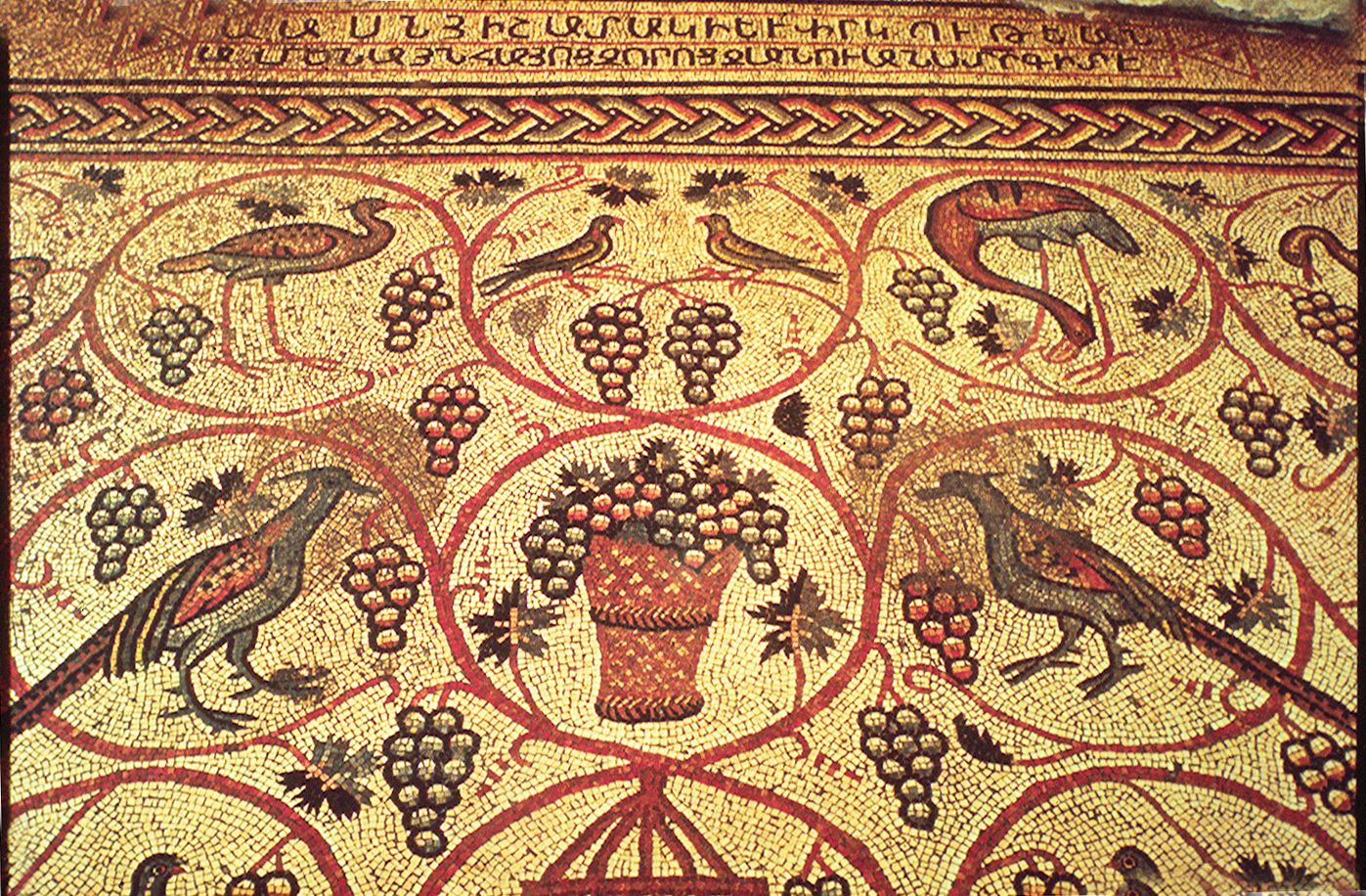
 Partial view of Armenian mosaic with inscription at top.
In 1894 an ancient mosaic floor was discovered in a house at 18 Street of the Prophets, 200 meters east of Damascus Gate. Known as the "bird mosaic", it depicts peacocks, ducks, storks, pigeons, an eagle, a partridge, and a parrot in a cage, along with branches and grape clusters, all symbols of death in early Christian art. An inscription at the top of the mosaic reads, "For the memory and salvation of all those Armenians whose name the Lord knows". Beneath a corner of the mosaic lay a natural cave containing human bones which were dated to the 5th or 6th century, indicating that the room was used as a mortuary chapel.[19]
Wartime occupation
During both world wars and the Israeli War of Independence, large buildings on the Street of the Prophets were appropriated for military use. The English Mission Hospital, for example, was used by the Ottoman army to house their wounded soldiers during World War I; in 1917, the British Mandate officials turned it into the headquarters for the 60th Division that conquered Jerusalem. The Italian Hospital headquartered the British Royal Air Force during World War II.[10]
East-west division
 Hadassah College Jerusalem (formerly Hadassah College of Technology)
During the 1929 riots in the Old City, Arabs also rioted in the Jewish neighborhoods of Kiriyah Ne'emana, Eshel Avraham and Chatzer Strauss outside Damascus Gate. Nineteen Jews were killed, synagogues and private homes were burned, and the Jews abandoned these areas.[8] Residents returned to Chatzer Strauss, but at the start of the 1936-1939 Arab revolt in Palestine, this neighborhood was evacuated by the British police,[20] turning the eastern side of Street of the Prophets into a de facto Arab neighborhood.
With the end of the British Mandate in 1948, Street of the Prophets continued to be divided in two by the Seam Line that separated Israeli West Jerusalem from Jordanian East Jerusalem. The eastern end of the street, forming a triangle with the Old City walls and the southern side of the neighborhood of Musrara, was part of the no man's land between Israel and Jordan.[1] The street was returned to Israel with the reunification of Jerusalem in 1967.
Controversial plans
 View looking west on Street of the Prophets.
In the late 1980s, a proposal was made to widen the narrow, two-lane street into a 32-meter-wide superhighway. The proposal met with stiff opposition from Jerusalem residents, as it called for destroying the historic garden courtyards of the buildings lining the street. An alternate plan called for laying the highway across the courtyards while retaining the outer stone walls to maintain the 19th-century look of the street. Neither plan has come to fruition.[3]
In late 2009, during construction on Jaffa Road for the Jerusalem Light Rail, Egged city buses that normally traversed Jaffa Road were diverted onto Street of the Prophets. The street also sees increased traffic as an alternate route for buses traveling to northern Jerusalem neighborhoods (via Road 1) whenever Straus Street is closed due to demonstrations.
In recent years, the city has granted permits for the development of high-rise, luxury apartment projects on and alongside Street of the Prophets. These projects are expected to alter the quiet, exclusive nature of the street.[2]
Present-day landmarks
Schools
 Jerusalem ORT campus, formerly home of the Provost at Redeemer Church.
- Anglican International School (#82)[21]
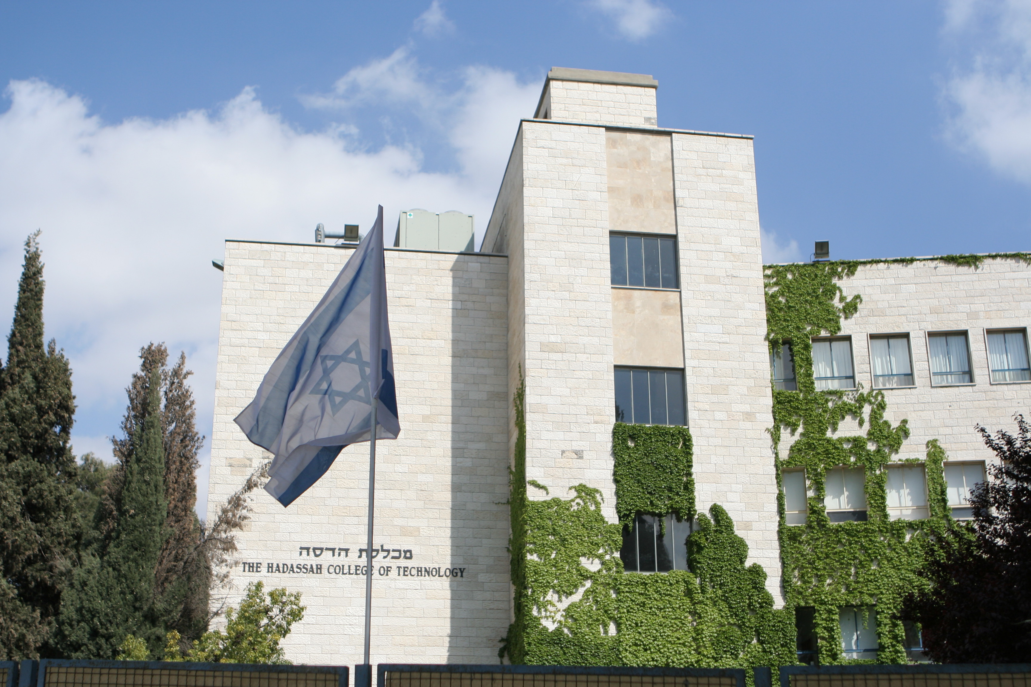
- Hadassah College Jerusalem (formerly Hadassah College of Technology) (#37)[22]
- Jerusalem ORT (#42)
- Lycée Française (French School) (#66)
Hospitals
- Bikur Holim Hospital
Between 1976-1988, a railway coach parked a few meters east of Bikur Holim Hospital housed the national headquarters for the Yad Sarah home-care equipment lending organization.[10][23] The building at #43 Street of the Prophets still bears the organization's name.
Christian organizations
 St. Joseph Convent
- International Evangelical Church (#55)
- St. Joseph of the Apparition Convent (#66)
- Swedish Theological Institute (#58)[24]
 Front view of the Italian Hospital, today the Ministry of Education and Culture.
Government offices
- Ministry of Education and Culture (Italian Hospital building)
- Ministry of Education office (Lev-Ram building)
- Ministry of Education (Mahanaim house)
Other
Memorials
- Davidka Square, at the western end of the street (corner Jaffa Road), commemorates the homemade mortar called the Davidka used during the Israeli War of Independence
- Mitzpe Tomer (Tomer Observation Post) at the eastern end of the street (corner Highway 60) commemorates the spot where, in April 2002, a traveling car bomb detonated, killing 19-year-old Israeli border policeman Mordechai Tomer
References
- ^ a b "Jerusalem Strolls: Haneviim and Ethiopia St.". jerusalemite.net. 2008-09-03. http://www.jerusalemite.net/blog/3111/jerusalem-strolls:-haneviim-and-ethiopia-st.. Retrieved 2010–07–11.
- ^ a b c "Street of the Prophets Plan". Sustainable Jerusalem Coalition. 2001. http://www.sustainable-jerusalem.org/old_site/jerusaleme/envir35.html. Retrieved 2010–07–11.
- ^ a b c d e "Ha-nevi'im Street". Jerusalem Municipality. http://www.jerusalem.muni.il/english/sys/tour/vir_tour/show/show_tour.asp?tour_id=100. Retrieved 2010–07–11.
- ^ a b Eisenberg, Ronald L. (2006). The Streets of Jerusalem: Who, What, Why. Devora Publishing Company. ISBN 1-932687-54-8. http://books.google.com/books?id=yqXXD_74yAEC&pg=PA243&lpg=PA243&dq=mahanayim+house+jerusalem&source=bl&ots=oqKYfOoRxY&sig=WV2b5r5UPIuVq3P6WJ6et7RiXNk&hl=en&ei=jVwmTKHMJYiNOOCtrMQC&sa=X&oi=book_result&ct=result&resnum=11&ved=0CDIQ6AEwCg#v=onepage&q=street%20of%20the%20prophets&f=false.
- ^ a b c Rossoff, Dovid (1998). Where Heaven Touches Earth: Jewish life in Jerusalem from medieval times to the present. Guardian Press. ISBN 0-87306-879-3.
- ^ a b c Bar-Am, Aviva. "A Guide to Buildings in Jerusalem". The Jerusalem Post. http://www.jposttravel.com/jerusalem_tours/Aguide-Jerusalem1108.html. Retrieved 2010–07–11.
- ^ Medoff, Rafael (Spring 2004). "An Unorthodox Rabbi on Capitol Hill: The legacy of Rabbi Baruch Rabinowitz". Jewish Action. http://www.bnaiabraham.net/Rabbi/Rabbi%20Baruch%20Rabinowitz/PROFILE.pdf. Retrieved 2010-07-11.
- ^ a b c Malka, Annette (2009-08-09). "Street of the Prophets, Jerusalem". terredisrael.com. http://translate.google.com/translate?hl=en&sl=fr&u=http://www.terredisrael.com/tourisme-israel.php%3Fid%3D3&ei=W5cvTKmsAcySOPbk9P4B&sa=X&oi=translate&ct=result&resnum=10&ved=0CDgQ7gEwCQ&prev=/search%3Fq%3Dyad%2Bsarah%2Bhaneviim%2B43%26hl%3Den%26safe%3Dactive. Retrieved 2010–07–11.
- ^ "About the Consulate". Consulate General of the United States/Jerusalem. 2009. http://jerusalem.usconsulate.gov/about_the_embassy.html. Retrieved 2010–07–11.
- ^ a b c d e f g h i j Bar Am, Aviva. "Rehov Hanevi'im — Around the houses". The Jerusalem Post. http://www.jposttravel.com/jerusalem_tours/RehovHaneviim1008.html. Retrieved 2010-07-11.
- ^ a b c d "The Ethiopian Consulate". Jerusalem Municipality. 2006-02-06. http://www.jerusalem.muni.il/jer_sys/picture/atarim/site_form_atar_eng.asp?site_id=504&pic_cat=4&icon_cat=6&york_cat=9. Retrieved 2010-07-11.
- ^ Zaun-Goshen, Heike (2007). "Beyond the Wall - Chapters on Urban Jerusalem". The Jerusalem Post. http://info.jpost.com/2000/Supplements/Millennium/centuries5.html. Retrieved 2010–07–11.
- ^ Green, Michael (2008-08-07). "Whose Property?". The Jerusalem Post. http://www.jpost.com/Home/Article.aspx?id=110374. Retrieved 2010–07–11.
- ^ a b Ginsberg, Michael Peled; Ron, Moshe (June 2004). Shattered Vessels: Memory, Identity, and Creation in the Work of David Shahar. State University of New York Press. ISBN 978-0791459195. http://books.google.com/books?id=Ju3K_gXrAF8C&pg=PA75&lpg=PA75&dq=mahanayim+house+frutiger+jerusalem&source=bl&ots=Y_Gy-A_16D&sig=lBYYJImyXWUju31ah-T3P8a438M&hl=en&ei=-2EmTJWpB9OHOMbz7NMC&sa=X&oi=book_result&ct=result&resnum=3&ved=0CBoQ6AEwAg#v=onepage&q=mahanayim%20house%20frutiger%20jerusalem&f=false.
- ^ Robin Twite, "Die Äthiopische Kirche – Afrika in Jerusalem", Ela Moszkowicz (trl.), in: Ariel: Eine Zeitschrift zur Kunst und Bildung in Israel, vol. 102 (1996; titled: 'Jerusalem mit 3000'), pp. 40-53, here p. 50.
- ^ "Herzl and Zionism". Israel Ministry of Foreign Affairs. 2004-07-20. http://www.mfa.gov.il/MFA/MFAArchive/2000_2009/2004/7/Herzl+and+Zionism.htm. Retrieved 2010-07-15.
- ^ Berger Holtz, Toby. The Hall Family and Ethiopia: A Century of Involvement, in: Proceedings of the 16th International Conference of Ethiopian Studies, Svein Ege, Harald Aspen, Birhanu Teferra and Shiferaw Bekele (eds.), Trondheim: Norges teknisk-naturvitenskapelige universitet / Sosialantropologisk institutt, 2009, pp. 109-117, here p. 114. ISBN 978-82-90817-27-0. "The Empress Taytu had convinced her adviser, [court-lady Welette-Iyesus (1850–1932), also known as] Katarina Hall, to persuade her son-in-law, Baron von Ustinov, to acquire property in Jerusalem near the Ethiopian Church. The land was purchased in 1910, and construction of a large building began. Baron von Ustinov … died in 1917. His widow Magdalena … inherited the land in Jerusalem and the partially completed building on it. During a trip to Jerusalem in 1924, she sold the property to the Empress Zauditu while the Empress was also visiting there. The Empress continued the construction on Ustinov's foundations. The building became the Ethiopian Consulate". (Addition in edged brackets and omissions are not in the original)
- ^ "Musrara/Morasha Quarter of Jerusalem". efratnetworks.com. http://www.efratnetworks.com/mus/history.html. Retrieved 2010–07–11.
- ^ "Armenian Mosaic, Jerusalem". sacred-destinations.com. 2010. http://www.sacred-destinations.com/israel/jerusalem-armenian-mosaic.htm. Retrieved 2010–07–11.
- ^ Hacohen, A. "A Leibidige Mesillas Yesharim" (Hebrew). Yated Ne'eman, 20 Tamuz 2010, issue 44, pp. 16-17.
- ^ "From the Executive". aisj.co.il. http://www.aisj.co.il/Welcome/AboutAISJ/FromtheExecutive/tabid/74/Default.aspx. Retrieved 2010-07-11.
- ^ "History". http://www.hadassah.ac.il/Site/PreAcademicEn/AboutCollege/History.asp. Retrieved 2010-07-11.
- ^ "Photo of Yad Sarah headquarters". Harakevet Magazine. September 1989. http://harakevetmagazine.com/downloads/HRKIssue5.pdf. Retrieved 2010–07–11.
- ^ "Swedish Theological Institute". Jerusalem Municipality. 2005-09-15. http://www.jerusalem.muni.il/jer_sys/picture/atarim/site_form_atar_eng.asp?site_id=197&pic_cat=4&icon_cat=6&york_cat=9. Retrieved 2010-07-11.
- ^ "Leila Mini Club (Hebrew)". atraf.co.il. 2010. http://www.atraf.co.il/clubs/club.aspx?cId=764. Retrieved 2010-07-11.
- ^ "Lulu". cruisinggays.com. 2010. http://www.cruisinggays.com/Jerusalem/Bars-Clubs/13584-Lulu. Retrieved 2010–07–11.
Sources
This article incorporates material from the Hebrew Wikipedia article, רחוב הנביאים
External links
Bar Ilan · Yehuda Burla · Ben Yehuda Street · Beit Hadfus Street · Bezalel Street · Hebron Road · Ruppin Boulevard · Ein Kerem Street · Emek Refaim · Ethiopia Street · Gaza Street · Pierre Koenig Street · HaPalmach · Herzog Street · Hativat Harel · Hativat Yerushalayim · Hatzanhanim · Heil Hahandasa · Hillel Street · Jaffa Road · Jabotinsky Street · Kanfei Nesharim Street · King George Street (Jerusalem) · Kovshei Katamon · Ma'ale HaShalom · Malchei Israel · Mea She'arim · Nablus Road · Ben Zakai Street · Sderot Ben Zvi · Sderot Golda Meir · Sderot Menachem Begin · Sderot Barlev · Herzl Boulevard · Levi Eshkol Boulevard · Shai Agnon Boulevard · Shazar Boulevard · Shivtei Israel · Shmuel HaNavi · Street of the Prophets · Strauss Street · Yaakov Pat · Yehezkel ·
YirmiyahuCoordinates: 31°47′02″N 35°13′24″E / 31.78389°N 35.22333°E
Categories:- Streets in Jerusalem


Wikimedia Foundation. 2010.