- Negros (island)
-
Negros 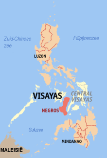
Map of the Philippines showing Negros
 Negros (island) (Philippines)
Geography Location South East Asia Archipelago Visayas Area 13,328.4 km2 (5,146.12 sq mi) Area rank 62nd Highest elevation 2,435 m (7,989 ft) Highest point Kanlaon Country PhilippinesProvince Negros Occidental, Negros Oriental Largest city Bacolod (pop. 429,076) Demographics Population 3,700,000 (as of 2000) Density 283 /km2 (733 /sq mi) Ethnic groups Visayan (Hiligaynon, Cebuano) Negros (Tagalog pronunciation: [ˈneɡros]) is an island of the Philippines located in the Visayas, at 10°N 123°E / 10°N 123°E. It is the third largest island in the country, with a land area of 13,328 km² (5,146 square mi.). Inhabitants of the island are called Negrenses.
Contents
Geography
Politically and linguistically, Negros is divided into two provinces: Negros Oriental in the Central Visayas region and Negros Occidental, part of the Western Visayas region. This division of the island, which roughly follows the mountain range in the center of the island, corresponds to the two ethno-linguistic groups. The western part (Occidental) is where the Ilonggo or Hiligaynon-speaking Negrenses are located, and the eastern portion (Oriental) is home to the Cebuano-speaking population.
The chief cities on the island are Bacolod in Negros Occidental and Dumaguete in Negros Oriental.
Negros is noted for being the country's prime producer of sugar. Sugar cane plantations abound in the agricultural areas of the island.
Kanlaon Volcano in the northern part of the island is one of the most active volcanoes in the Philippines, and overlooks Bacolod. It is the highest peak on the island as well as of all the Visayas region. Other notable peaks on the island are Mt Silay and Mt Mandalagan in Negros Occidental, and Cuernos de Negros in Negros Oriental.
The volcanic activity in Negros is harvested into electricity through two geothermal power plants in the island. One is located in Palinpinon, Negros Oriental, and the other, to open in 2007, is in Mailum, Negros Occidental.
History
Negros Island was originally called Buglas – an old native word thought to mean "cut off." It is believed that Negros was once part of a greater mass of land, but was cut off either by what geologists call continental drift or by rising waters during the Ice age. Among its earliest inhabitants were dark-skinned natives belonging to the Ati, one of several indigenous Negrito ethnic groups dispersed throughout Asia, who had a unique culture.
Thus, the Spaniards called the land Negros after the black natives they saw on their arrival on the island in April 1565. Two of the earliest native settlements, Binalbagan and Ilog, became towns in 1573 and 1584, respectively. Other settlements were Hinigaran, Bago, Marayo (now Pontevedra), Mamalan (now Himamaylan), and Candaguit (a sitio of San Enrique). In 1572 the Spanish King Philip II conferred the title of Marques de Buglas to the heirs of Juan Sebastian Elcano. The 17th and current Marques resides in Silay City, Negros Occidental.
After appointing encomenderos for the island, Miguel López de Legazpi placed Negros under the jurisdiction of the governor of Oton on Panay. In 1734, however, the island became a military district and Ilog was made its first capital. The seat of government was later transferred to Himamaylan until Bacolod became the capital in 1849.
In 1890, the island was divided into Negros Occidental and Negros Oriental. On April 9, 1901, the Second Philippine Commission under the Chairmanship of William H. Taft, arrived in Dumaguete. On May 1, 1901, the civil government under American rule was established. On August 28, of the same year Dr. David S. Hibbard founded Silliman Institute now Silliman University with the help of Meliton Larena the first town mayor of Dumaguete & Hon Demetrio Larena.
On 11 July 2011, a magnitude 6.4 earthquake struck Negros Island, with it's epicentre near Sipalay City. No one was killed, but some serious damage was reported on the island.
Republic Era
Main article: Republic of NegrosFrom November 3 to November 6, 1898, the Negrenses rose in revolt against the Spanish authorities headed by politico-military governor Colonel Isidro de Castro. The Spaniards decided to surrender upon seeing armed troops marching in a pincer movement towards Bacolod. The revolutionaries, led by General Juan Araneta from Bago and General Aniceto Lacson from Talisay, were actually carrying fake arms consisting of rifles carved out of palm fronds and cannons of rolled bamboo mats painted black. By the afternoon of November 6, Colonel de Castro signed the Act of Capitulation, thus ending Spanish rule in Negros Occidental. This event is commemorated in Negros Occidental every November 5 as the day the Negrenses bluffed the Spaniards to attain their freedom.
For a detailed article on this event, see Negros Revolution.November 5 has been declared a special non-working holiday in the province through Republic Act. No. 6709 signed by President Corazon Aquino on February 10, 1989.
On November 27, 1898, the Cantonal Republic of Negros was established. It came under U.S. protection on April 30, 1899. On July 22, 1899, it was renamed the Republic of Negros (República de Negros), but on April 30, 1901, this was dissolved by the United States.
Leaders
The leaders of the short-lived republic were:
- Aniceto Lacson, November 5, 1898 – July 22, 1899 (to November 27, 1898, in Negros Occidental)
- Demetrio Larena, November 24, 1898 – November 27, 1898 (in Negros Oriental)
- President of the Constituent Assembly José Luzuriaga, July 22, 1899 – November 6, 1899
- Secretary of War Juan Araneta
- Civil Governor Melecio Severino, November 6, 1899 – April 30, 1901
- Secretary of Justice Antonio Ledesma Jayme, July 24, 1854 – October 9, 1937
Negrenses to mean people of Negros has never been popular and accepted by the public. They are not acceptable and have never been accepted by the populace. Out there in the world, people still say Negrosnon, Bacolodnon, Hinigaranon, Binalbaganon, Himamaylanon, Kabankalanon, Ilognon, and so on. Because it is not custom and tradition of majority of Filipinos to mutilate name of places. They just add, in the case of Hiligaynon, the suffix non to mean people of, belonging to, to the name of the place. There are instances when Spanish and English affixes are adopted, but just the same, they don’t mutilate or mutilate much.
Negrense is widely viewed as elitist word.
Negrense society
Historically, Negros Oriental has a rich history of the bourgeois and the élite, as well as those descended/related to Spanish nobility. The landed hacenderos of the island, which includes Negros Occidental, often keep track of each other, attend each other's parties, and intermarry. They may have different "kingdoms"—the Bais-Tanjay-Dumaguete-Pamplona families, the Victorias-Cadiz-Sagay families, the Bayawan-Santa Catalina-Basay-Sipalay families, the Kabankalan-Ilog-Himamaylan families, the Canlaon-Guihulngan-Vallehermoso-San Carlos families, the Bacolod-La Carlota-Silay-Talisay families—but most are sugar barons welded together by common crop, a shared fortune, as well as accidents of history. People in Manila may not recognize that the "true-blue high society" they know there actually spring from four very interconnected points of the Visayas—Iloilo, Bacolod, Bais-Tanjay, and Cebú.The famous family in the Sugar Industry of Negros are the Álvarez, Montilla, de López*****, Lopez, L'huiller***, Villanueva, Preysler****, del Prado*, Arroyo, Abellò*, Larena*, Lizares, Ledesma, Teves**, de Villegas*****, Montenegro*, de Vicente*, Romero*, de García*, Garcia, and Araneta.
- of Spanish descent
- used to hold Latifúndias or be Latifunderos
- French descent
- German descent, Spanish intermarriage
- related to/descended from members of Spanish nobility
- German descent, Spanish intermarriage
- French descent
- used to hold Latifúndias or be Latifunderos
Dumaguete, Negros Oriental is unusual in its strong American influence that has produced an upper/upper middle class of mostly non-Spanish stock (including those with Chinese roots) who hold great sway in local things political, social, economic, and cultural development .The Spanish traditionally contributed to local high society was their sense of fabulous fiesta, especially during "Sipong", their annual celebration of harvest, a fête that ran from Vallehermoso, Bais to Tanjay to the seaside houses along Rizal Ave in the famous Boulevard. What the Americans brought with them was a sense of high culture, and that was when Negros learned to appreciate Shakespearean plays, operas, dances,party and concerts
References
External links
Categories:- Visayan Islands


Wikimedia Foundation. 2010.