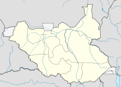
- Nasir, South Sudan
-
Nasir
Warkai, ChoghokakLocation in South Sudan Coordinates: 8°36′N 33°4′E / 8.6°N 33.067°ECoordinates: 8°36′N 33°4′E / 8.6°N 33.067°E Country  South Sudan
State Upper Nile County Luakpiny/Nasir County Time zone East Africa Time (UTC+3) Nasir is a small town in Upper Nile state, South Sudan.[1] The town is on the north side of the Sobat River, about 30 kilometres (19 mi) as the crow flies from the Ethiopian border. It is the administrative center of Luakpiny/Nasir County.
Contents
Early days
Charles W. Gwynn passed through this town while he was reconnoitering the Ethiopian-Sudan border in March 1900. There he found "a young Egyptian officer in charge of a small Government post, but he apparently had had no communications with anyone since the river [the Sobat] had fallen, and was anxiously awaiting its rise in hopes of a steamer to replenish his stores."[2]
Civil war
SPLA-Nasir, a splinter faction of the Sudan People's Liberation Army active from 1991 to 1994, derived their name from the town because it was their base.
References
- ^ Maplandia world gazetteer
- ^ Gwynn, "The Frontiers of Abyssinia: A Retrospect", Journal of the Royal African Society, 36 (1937), p. 157
External links
Categories:- Populated places in South Sudan
- Upper Nile (state)
- Greater Upper Nile
- South Sudan geography stubs
Wikimedia Foundation. 2010.


