- Moturata / Taieri Island
-
Moturata/Taieri Island Maori: Moturata/Taieri 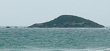
Moturata/Taieri Island.Geography Location Otago Region Coordinates 46°03′28″S 170°13′03″E / 46.057812°S 170.217369°E Country Demographics Population 0 Moturata, also called Taieri Island, is an island in the mouth of the Taieri River in southern New Zealand. It is connected to the mainland by a sandy causeway at low tide.
The island is a nature reserve, and is home to many protected seabirds, notably Yellow-eyed Penguins. It was the site of a whaling station in the 1830s and 40s. In winter(June), 2006, a pod of four Southern Right Whales were seen frolicking off Taieri Mouth. The group were composed of 3 males and 1 female, thought to be a mating group which had not been observed in the waters of New Zealand for long period.[1]
Taieri Island may have been the 'Isle of Wight' where The Brothers, a Sydney sealer chartered by Robert Campbell and commanded by Robert Mason landed eight of a gang of eleven men in November 1809. William Tucker, to Maori 'Taka' and 'Wioree' who settled in 1815 at Whareakeake (Murdering Beach) near the Otago Heads, was in the gang. Alternatively the 'Isle of Wight' may be Green Island a few kilometres along the coast to the north.
In 1839 the Weller brothers of the Otago station on Otago Harbour established an outstation at Taieri Island which they operated for three years. Edward Shortland recorded it caught 70 tuns of oil in 1839, 15 in 1840 and 8 in 1841. The station operated under Mr. Cureton. In the evening of 9 June 1839 the Dublin Packet, Captain Wells, which had been at Otago was wrecked while attempting to pick up oil from the island station. She lost the second mate, the steward and a mentally ill man named 'Dole' or 'Cole' who was being sent from the Wellers' Otago station to Sydney.
In 1844 John Jones of Waikouaiti briefly revived whaling on the island where Tommy Chaseland, a half-caste Australian aboriginal, with his wife Puna, Te Matenga Taiaroa's sister, presided over the gang. According to the visiting Frederick Tuckett, 'nowhere, perhaps, do twenty Englishmen reside on a spot so comfortless as this naked inaccessible isle'.
Coordinates: 46°03′28″S 170°13′03″E / 46.057812°S 170.217369°E
See also
References
External links
Categories:- Uninhabited islands of New Zealand
- Otago Region

Wikimedia Foundation. 2010.