- Mid-Tertiary ignimbrite flare-up
-
Mid-Tertiary ignimbrite flare-up 
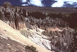
The Fish Canyon Tuff ignimbriteVolcano Multiple cumulative events Date 25-40 million years ago Type Hawaiian, Strombolian, and/or Vulcanian Location Western United States VEI 1-3 Impact Deposited vast swatches of ignimbrite across the western United States The Mid-Tertiary ignimbrite flare-up, as the name implies, is a dramatic period of volcanic eruptions in mid-Tertiary time, approximately 25-40 million years ago, centered in the western United States.[1] These eruptions are seen today as deposits of ignimbrite, the pyroclastic material that was laid down from these eruptions.
Contents
Overview
There are countless eruptions within the flare-up; the total volume is 500,000 to 5,000,000[2] cubic kilometers (km3). This amount is on par for some of the largest non-explosive volcanic provinces (see World's largest eruptions). For reference, the 1980 eruption of Mt. St. Helens was about 1 km3. The largest eruption on the flare-up, and also the largest explosive eruption ever known, was the Fish Canyon tuff in southwest Colorado. Its volume alone is 5,000 km3. The three primary volcanic centers of the flare-up are the Central Nevada volcanic field of central Nevada, Indian Peak volcanic field of eastern Nevada/western Utah, and the San Juan volcanic field in Colorado.
Cause
The primary tectonic driving force behind this explosive volcanic activity is slab roll back.[3] During the Laramide orogeny, the subducting Farallon Plate subducted at a very shallow angle. When this stopped, the mantle wedge was opened up, and the result was the flare-up. The specifics of this opening, including possible windows or buckling of the plate, can explain specific volcanic trends within the flare-up.
See also
References
- ^ Cannon, Eric. "The Mid-Tertiary ignimbrite flare-up". http://www.colorado.edu/GeolSci/Resources/WUSTectonics/CzIgnimbrite/ignimbrite_intro.html. Retrieved 14 August 2010.
- ^ Cannon, Eric. "1. Introduction: The Mid-Tertiary ignimbrite flare-up". http://www.colorado.edu/GeolSci/Resources/WUSTectonics/CzIgnimbrite/INVESTIGATION/SECTION_1/investigation_intro.html. Retrieved 14 August 2010.
- ^ Cannon, Eric. "5. Tectonics: The Mid-Tertiary ignimbrite flare-up". http://www.colorado.edu/GeolSci/Resources/WUSTectonics/CzIgnimbrite/INVESTIGATION/SECTION_1/tectonics_intro.html. Retrieved 14 August 2010.[dead link]
Categories:- Volcanic events
Wikimedia Foundation. 2010.
