- Menchum River
-
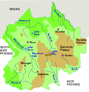 Northwest region. Menchum River in the west.
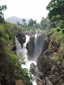 Menchum Falls
The Menchum River and its tributaries drains a large area of the Northwest Region of Cameroon. It in turn is a tributary of the Benue River in Nigeria.[1]
Contents
Location
The Menchum, Donga and Katsina Ala rivers all flow west from the Northeast Region to join the Benue in Nigeria.[2] The Menchum drains the Oku-Kom highlands, which have an elevation of 2,400 metres (7,900 ft) around Lake Oku, falling to about 800 metres (2,600 ft) at Mbonkissu to the west of Fundong. The highlands, formed by volcanic action, have been dissected by steep valleys carved out by fast-flowing streams.[3]
Hydroelectric potential
The Menchum Falls, about 20km south of Wum and 30km north of Bafut, are impressive and a potential tourist attraction. However, the access road is very rough, and the viewing site is not well maintained.[4] A 2003 guide stated that the road was virtually impassable in the rainy season.[5] On 7 September 2009, Agreenergy and the Government of Cameroon signed a Memorandum of Understanding for a project to build a dam and 90MW hydroelectric power plant on the river. Apart from bring electricity and jobs, the project would involve surfacing the road.[6] On 8 December 2010 President Paul Biya announced plans to construct a dam on the Menchum Falls.[7]
Environmental issues
The rich volcanic soils in the highlands have attracted farmers and grazers, and the resulting land clearances have made the area vulnerable to soil erosion.[3] The Menchum Valley is low-lying, and used to be covered in equatorial forests. These have mostly been cleared for their timber, leaving open grassland that is used for grazing, and is subject to erosion on the slopes. Efforts are being made to reforest the valley.[1]
References
- ^ a b "The Menchum Valley, North West Province, Cameroon". UNAFAS. 16 February 2007. http://www.unafas.org.uk/files/tree%20planting%20menchum%20valley.pdf. Retrieved 2011-02-06.
- ^ Fon Nsoh, Fomboh Abraham Afese and Neba Celestine (25 August 2006). "DEVELOPING BIODIVERSITY INDICATORS AS A TOOL FOR REGULATING DEVELOPMENT ACTIVITIES IN AND AROUND PROTECTED AREAS AND WETLAND REGIONS IN THE NORTH WEST PROVINCE OF CAMEROON". Community Initiative for Sustainable Development. http://people.exeter.ac.uk/rwfm201/cbbia/downloads/PAPreports/CameroonPAPreport.pdf. Retrieved 2011-02-06.
- ^ a b Zephania Nji Fogwe and Michel Tchotsoua (2010). "Ecological Adaptability and Slope-Trait Considerations for Water and Soil Conservation on the Vulnerable Oku-Kom Plateau in the Western Highland of Cameroon". Kamla-Raj. http://www.krepublishers.com/02-Journals/JHE/JHE-30-0-000-10-Web/JHE-30-1-000-2010-Abst-PDF/JHE-30-1-019-10-1904-Fogwe-Z-N/JHE-30-1-019-10-1904-Fogwe-Z-N-Tt.pdf. Retrieved 2010-02-06.
- ^ Auke VanderHoek (TUESDAY, AUGUST 18, 2009). "Menchum Falls: Where is the tourist industry?". The Vanguard. http://news.vanguardcameroon.com/2009/08/menchum-falls-where-is-tourist-industry.html. Retrieved 2011-02-06.
- ^ Jim Hudgens, Richard Trillo (2003). "Wum and around". The rough guide to West Africa. Rough Guides. p. 1207. ISBN 1843531186. http://books.google.ca/books?id=iRoSWScaz-YC&pg=PA1207.
- ^ Joseph Tihngang (January 24, 2010). "Menchum Power Project". http://xa.yimg.com/kq/groups/16288544/1331645358/name/Menchum+power+project.pdf. Retrieved 2011-02-06.
- ^ Nkendem FORBINAKE (08 December 2010). "Celebration Day In Bamenda". Cameroon Tribune. http://www.cameroon-tribune.cm/index.php?option=com_content&view=article&id=62392:high-moments-of-land-mark-event&catid=1:politique&Itemid=3&showall=1. Retrieved 2011-02-06.
Coordinates: 6°15′53″N 10°02′23″E / 6.264793°N 10.039787°E
Categories:- Cameroon geography stubs
- Rivers of Cameroon


Wikimedia Foundation. 2010.