- Meard Street
-
Coordinates: 51°30′48″N 0°07′59″W / 51.5133°N 0.133°W
Meard Street in a street in Soho, London. It runs roughly East-West (properly, East-Northeast to West-Southwest, as elsewhere in Soho), between Wardour Street to the west and Dean Street to the east. It is in two sections, with a slight bend in the middle: the west half is pedestrianised, while the east half is a narrow single lane road.
The street is named for John Meard, the younger, a carpenter, later esquire, who developed it in the 1720s and 1730s.[1]
It is prominently featured in photographs and postcards for the tourist trade, due to the pun with French: merde ("shit").
Contents
History
The two halves occupy what were originally two separate, non-communicating 17th century courts. They were developed in two halves: the western half, Meard's Court, in 1722, and the eastern half, Dean's Court (opening off Dean Street, and renamed Meard Street) in 1731/32. As part of the redevelopment of Dean's Court, the two halves were joined in 1732/33.[1]
Notable occupants
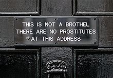
 The sign at the entrance to the home of Sebastian Horsley.
- Batcave, birthplace of English goth subculture
- Sebastian Horsley, artist and dandy; number 7[2][3]
See also
- St. Anne's Court
References
- ^ a b (Sheppard 1966)
- ^ Debriefer: The Crucifixated Sebastian Horsley, November 23, 2007, http://gridskipper.com/archives/entries/063/63657.php
- ^ Sebastian Horsley (March 23, 2007), (blog post of March 23, 2007), http://sebastianhorsley.typepad.com/sebastian_horsley/2007/03/post.html
- Sheppard, F. H. W. (1966), "The Pitt Estate in Dean Street: Meard Street", Survey of London: volumes 33 and 34: St Anne Soho, pp. 238–246, http://www.british-history.ac.uk/report.aspx?compid=41104, retrieved 2009-07-29
Categories:- Streets in Westminster
- London road stubs
Wikimedia Foundation. 2010.
