Meander scar

Meander scar
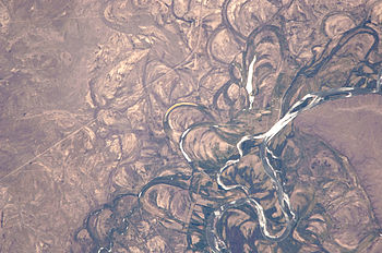
Spectacular meander scars, oxbow lakes and abandoned meanders in the broad flood plain of the Rio Negro, Argentina. 2010 astronaut photo from ISS.

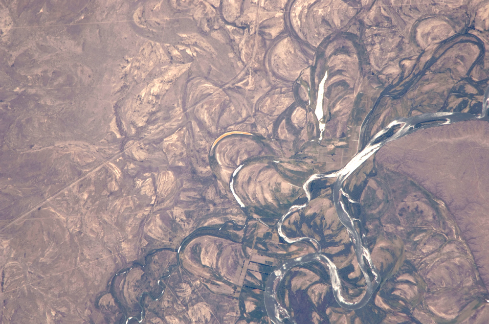
A meander scar, occasionally meander scarp,[1] is a geological feature formed by the remnants of a meandering water channel. They are characterized by "a crescentic cut in a bluff or valley wall, produced by...a meandering stream."[2][3][4] They are often formed during the creation of oxbow lakes.[5][6][7]

The term itself may refer alternatively to the actual cuts into the bank of a bluff,[1] or to the general feature of a drying or dried meander.[5] Both uses, however, describe features of the same process.

Meander scars are caused by the varying velocities of current within the river channel. Due to higher velocity current on the outer banks of the river through the bend, more erosion occurs causing the characteristic steep outer slopes.[1] In certain habitats, if the scar has sufficient water, or as an oxbow lake fills with sediment, these areas may become marshes or wetlands.[8]

References

  1. ^ a b c Christopher G. Morris, Academic Press dictionary of science and technology, Gulf Professional Publishing, 1992, ISBN 0122004000, page 1333
  2. ^ Robert Latimer Bates, Julia A. Jackson, American Geological Institute, Dictionary of geological terms, Random House, Inc., 1984, ISBN 0385181019, page 315
  3. ^ Encyclopaedic Dictionary of Geography, M.S. Rao, 2005, ISBN 8174881549, page 745
  4. ^ Jesse V. Howell, Glossary of geology and related sciences: a cooperative project of the American Geological Institute, 1960, page 180
  5. ^ a b Ann Bowen, John Pallister, Understanding GCSE Geography, page 40, Heinemann, 2006, ISBN 0435351710
  6. ^ Stephen Codrington, Planet geography, Solid Star Press, 2005, ISBN 0957981937, page 158
  7. ^ Gregorich, Soil and environmental science dictionary, CRC Press, 2001, ISBN 0849331153, page 221
  8. ^ Ritter, Michael E., The Physical Environment: an Introduction to Physical Geography, 2006, [1]

Wikimedia Foundation. 2010.

Игры ⚽ Поможем написать реферат

Look at other dictionaries:

  • meander scar — senvagė statusas T sritis ekologija ir aplinkotyra apibrėžtis Upės buvusios vagos arba jos atšakos ruožas, sąnašų visiškai arba iš dalies atskirtas nuo vagos. atitikmenys: angl. bead river channel; former rivermeander; meander scar; ox bow lake… …   Ekologijos terminų aiškinamasis žodynas

  • meander scar —     a) A crescent shaped, concave or linear mark on the face of a bluff or valley wall, produced by the lateral erosion of a meandering stream which impinged upon and undercut the bluff; if it’s no longer adjacent to the modern stream channel it… …   Glossary of landform and geologic terms

  • meander — meanderer, n. meanderingly, adv. /mee an deuhr/, v.i. 1. to proceed by or take a winding or indirect course: The stream meandered through the valley. 2. to wander aimlessly; ramble: The talk meandered on. v.t. 3. Survey. to define the margin of… …   Universalium

  • Meander — /mee an deuhr/, n. ancient name of the Menderes. * * * Extreme U bend in a stream, usually occurring in a series, that is caused by flow characteristics of the water. Meanders form in stream deposited sediments and may stack up upstream of an… …   Universalium

  • Meander — For other uses, see Meander (disambiguation). A hypothetical stream bed following a tilted valley. The maximum gradient is along the down valley axis represented by a hypothetical straight channel. Meanders develop, which lengthen the course of… …   Wikipedia

  • Vicksburg Campaign — Lithograph of the Mississippi River Squadron running the Confederate blockade at Vicksburg on April 16, 1863 …   Wikipedia

  • Battle of Big Black River Bridge — Infobox Military Conflict conflict=Battle of Big Black River Bridge caption=Grant s Operations against Vicksburg partof=the American Civil War date=May 17, 1863 place=Hinds County, Mississippi result=Union victory combatant1= flagicon|USA|1861… …   Wikipedia

  • Mott Archaeological Preserve — Mott Mounds 16 FR 11 Layout of the mounds at the Mott Site …   Wikipedia

  • cutbank —     a) A slope or wall portion of a cut excavated into unconsolidated material (regolith) or bedrock, as in a borrow pit. It may stand nearly vertical resulting from collapse as the base is undercut during excavation or by erosion, or it may be… …   Glossary of landform and geologic terms

  • faceted spur —    The inverted V shaped end of a ridge that has been truncated or steeply beveled by steam erosion (e.g., meander scar or bluff), glacial truncation, or fault scarp displacement.    Compare: spur.    SW …   Glossary of landform and geologic terms

Share the article and excerpts

Direct link
Do a right-click on the link above
and select “Copy Link”