Mały Staw

Mały Staw
Mały Staw
Lake
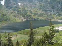
Country Poland
Region Lower Silesian Voivodeship
Range Krkonoše
Elevation 1,183 m (3,881 ft)
Coordinates 50°44′54.22″N 15°42′3.72″E / 50.7483944°N 15.7010333°E / 50.7483944; 15.7010333
Depth 7 m (23 ft)
Surface area 2.8 ha (7 acres)
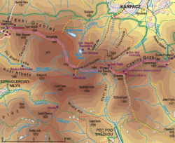
Location of Mały Staw within the Central Krkonoše

Mały Staw (1,183 m (3,881 ft), Polish for The Small Pond) is a natural lake of glacial origin in the Krkonoše mountains in western Poland. It is situated in the Polish Karkonosze National Park at the bottom of the cirque, on the southern slope of the Smogornia mountain, 1 km south of Wielki Staw[1].

With its area of 2.8 hectares[2], it is the second biggest glacial lake in the whole range. Its depth reaches 7 m. The place is accessible from the Polish-Czech Friendship Trail (red marks) and a blue marked short distance trail from Równia pod Śnieżką. A mountain hut Samotnia is situated on the north shore.

References


Wikimedia Foundation. 2010.

Игры ⚽ Поможем написать реферат

Look at other dictionaries:

  • Polish–Czech Friendship Trail — Signs on the route The Polish–Czech Friendship Trail (Czech: Cesta česko polského přátelství, Polish: Droga Przyjaźni Polsko Czeskiej) is a public walking path in the Karkonosze Mountains (Giant Mountains). The path runs on both sides of the… …   Wikipedia

  • Karkonosze — The Karkonosze [IPA pl|k|a|r|k|o| |n|o|sz|e] (Polish) or Krkonoše IPAlink|ˈkr̩konoʃɛ Audlisten|Cs Krkonose.ogg (Czech), also known as the Giant Mountains ( de. Riesengebirge), is a mountain range in the Sudetes, divided between Poland and the… …   Wikipedia

  • Karkonoski-Nationalpark — Riesengebirge – Schneekoppe mit Schlesierhaus (Schronisko Dom Śląski) Topographie des Riesengebirges (100 fach überhöht) Das Riesengebirge (p …   Deutsch Wikipedia

  • Karkonosze — Riesengebirge – Schneekoppe mit Schlesierhaus (Schronisko Dom Śląski) Topographie des Riesengebirges (100 fach überhöht) Das Riesengebirge (p …   Deutsch Wikipedia

  • Krkonose — Riesengebirge – Schneekoppe mit Schlesierhaus (Schronisko Dom Śląski) Topographie des Riesengebirges (100 fach überhöht) Das Riesengebirge (p …   Deutsch Wikipedia

  • Krkonoše — Riesengebirge – Schneekoppe mit Schlesierhaus (Schronisko Dom Śląski) Topographie des Riesengebirges (100 fach überhöht) Das Riesengebirge (p …   Deutsch Wikipedia

  • Krkonošský národní park — Riesengebirge – Schneekoppe mit Schlesierhaus (Schronisko Dom Śląski) Topographie des Riesengebirges (100 fach überhöht) Das Riesengebirge (p …   Deutsch Wikipedia

  • Riesengebirge — p1p5 Riesengebirge Obří důl (Riesengrund) mit der Schneekoppe (Sněžka) Höchster Gipfel …   Deutsch Wikipedia

  • sadzawka — ż III, CMs. sadzawkawce; lm D. sadzawkawek «zbiornik wodny w naturalnym lub wykopanym zagłębieniu ziemi; mały staw» …   Słownik języka polskiego

  • stawek — m III, D. stawekwku, N. stawekwkiem; lm M. stawekwki «mały staw zbiornik wody» Błotnisty, zamulony stawek …   Słownik języka polskiego

Share the article and excerpts

Direct link
Do a right-click on the link above
and select “Copy Link”