Mali i Thatë

Mali i Thatë

Mali i Thatë is a mountain in southeast Albania and a part of it being in southwest of Macedonia (known with the name Galičica and declared a National Park) with the highest altitude of 2287 meters. It borders Lake Prespa in the east, Lake Ohrid in northwest and overlooks the city of Pogradec to the west. It stretches 25 km from north to south and is 8 km wide in its central part. Mali i Thatë highest peak is Pllaja e Pusit (meaning "Well's plateau")and it reaches an altitude of 2,287 m (7,503 ft) above sea level. It is found within Albania, close to the Macedonian border and from this high peak, among several mountains of Albania, both Ohrid Lake and Prespa Lake can be seen, as well as the third highest peak in the Republic of Macedonia, Baba Mountain or Pelister Mountain (2601 m). The mountain has an anticlinal shape and is almost completely composed of mesozoic limestone formations.[1] Mali i Thatë has craggy slopes (especially the western face), whereas its crest is almost flat but full of carstic cavities.
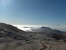
A View from the crest of Mali i Thatë.
Looking towards south from the crest of Mali i Thatë (Dry Mountain) where Mount Gramos (Alb. Mali i Gramozit) can be seen from 65 km of aerial distance.

The vegetation is primarily made up of alpine meadows, whereas in the eastern face beech, oak and bush forests are found. Near the Albanian village of Goricë the soil is rich of iron bauxite and chalk minerals.[1]

See also

References

  1. ^ a b "Fjalori Enciklopedik Shqiptar", by Akademia e Shkencave e RPSSH, Tiranë, 1985 page 664

Coordinates: 40°53′N 20°50′E / 40.883°N 20.833°E / 40.883; 20.833


Wikimedia Foundation. 2010.

Игры ⚽ Поможем решить контрольную работу

Look at other dictionaries:

  • Mali i Thatë — p1f1p5 Mali i Thatë Höchster Gipfel Pllaja e Pusit (2.287 m ü. A.) Lage Albanien …   Deutsch Wikipedia

  • Mali i Thatë — Sp Tãtės kalna Ap Mali i Thatë L Albanijoje …   Pasaulio vietovardžiai. Internetinė duomenų bazė

  • Mali (Begriffsklärung) — Mali bezeichnet: die Republik Mali in Westafrika die Mali Föderation das Mali Ideogramm, Wappen der Mali Föderation ein westafrikanisches Reich, siehe Malireich eine Präfektur in Guinea, siehe Mali (Präfektur) einen Ort in Guinea, siehe Mali… …   Deutsch Wikipedia

  • Mali i Ivanit — Dieser Artikel oder Abschnitt ist nicht hinreichend mit Belegen (Literatur, Webseiten oder Einzelnachweisen) versehen. Die fraglichen Angaben werden daher möglicherweise demnächst gelöscht. Hilf Wikipedia, indem du die Angaben recherchierst und… …   Deutsch Wikipedia

  • Liste der Berge in Albanien — Dies ist eine Liste der Berge oder Erhebungen in Albanien. Rang Gipfel Höhe in Meter Gebirge / Massiv Kreis (alb.: Rreth) 1. Korab 2.751 Vargu Lindor (Ostkette) Dibra 2 …   Deutsch Wikipedia

  • Liste der Berge oder Erhebungen in Albanien — Dies ist eine Liste der Berge oder Erhebungen in Albanien. Rang Gipfel Höhe in Meter Gebirge / Massiv Kreis (alb.: Rreth) 1. Korab 2.751 Vargu Lindor (Ostkette) Dibra 2 …   Deutsch Wikipedia

  • Pllaja e Pusit — Dieser Artikel oder Abschnitt ist nicht hinreichend mit Belegen (Literatur, Webseiten oder Einzelnachweisen) versehen. Die fraglichen Angaben werden daher möglicherweise demnächst gelöscht. Hilf Wikipedia, indem du die Angaben recherchierst und… …   Deutsch Wikipedia

  • AL-PG — Das Dorf Lin am Ohridsee Der Kreis Pogradec (albanisch: Rrethi i Pogradecit) ist einer der 36 Verwaltungskreise Albani …   Deutsch Wikipedia

  • Liste der höchsten Berge Albaniens — Dies ist eine Liste einiger Berge in Albanien, geordnet nach Höhe über Meer. Gipfel Höhe in Meter Gebirge / Massiv Kreis (alb.: Rreth) Korab 2751 Vargu Lindor (Ostkette) Dibra Jezerca …   Deutsch Wikipedia

  • Tetovo — Тетово Tetova/Tetovë …   Deutsch Wikipedia

Share the article and excerpts

Direct link
Do a right-click on the link above
and select “Copy Link”