Dulas, Herefordshire

Dulas, Herefordshire
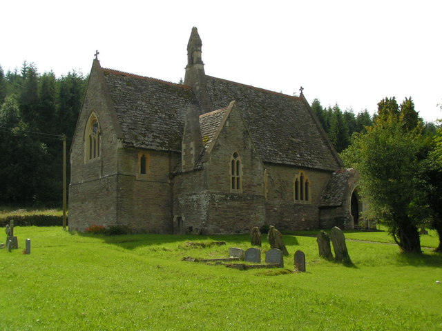
The church of St. Michael, Dulas.

Dulas is a civil parish in the County of Herefordshire in England 18 km south west of Hereford. There is no village as such named Dulas; the parish consists mainly of scattered farms and dwellings. The major buildings within the parish are Dulas Court, a Victorian country house now used as a residential home, and the now redundant church of St. Michael. This is the replacement for a much older building, which was demolished when the Court was built; all that remains of the original church are an ancient cross and a couple of gravestones on the front lawn of the residential home.

Due to the unspoilt rural nature of the parish it is home to some nationally rare wildlife. The churchyard hosts a variety of orchids, and the Dulas brook that runs through the parish is home to otters and white-clawed crayfish.

External links

The Dulas parish plan from 2004. [1]

The diocesan website, containing details about the church. [2]

Coordinates: 51°57′43″N 2°54′47″W / 51.962°N 2.913°W / 51.962; -2.913


Wikimedia Foundation. 2010.

Игры ⚽ Нужно решить контрольную?

Look at other dictionaries:

  • Dulas — may refer to: Saints in the Eastern Orthodox calendar Dulas (saint) Dulas of Cilicia Places Dulas, Anglesey, a village in Wales Dulas Bay, nearby Dulas, Herefordshire, a civil parish in England See also Dulas is a common name for watercourses in… …   Wikipedia

  • List of civil parishes in Herefordshire — This is a list of civil parishes in Herefordshire, England. A * Abbey Dore * Aconbury * Acton Beauchamp * Adforton * Allensmore * Almeley * Ashperton * Aston Ingham * Avenbury * Aylton * Aymestrey B * Bacton * Ballingham * Bartestree * Belmont… …   Wikipedia

  • Cusop — Coordinates: 52°04′01″N 3°06′36″W / 52.067°N 3.110°W / 52.067; 3.110 …   Wikipedia

  • List of abbeys and priories in England — Contents 1 Overview 1.1 Article layout 2 Abbreviations and key …   Wikipedia

  • Commote — Map of Wales A commote (Welsh cwmwd, plural cymydau, less frequently cymydoedd[1]), sometimes spelt in older documents as cymwd, was a secular division of land in Medieval Wales. The word derives from the prefix cym ( together , with ) and the… …   Wikipedia

  • Hay-on-Wye — infobox UK place country = Wales welsh name= Y Gelli Gandryll constituency welsh assembly= official name= Hay on Wye latitude= 52.08 longitude= 3.13 unitary wales= Powys lieutenancy wales= Powys constituency westminster= Brecon Radnorshire post… …   Wikipedia

  • List of postcode districts in the United Kingdom — This is a list of postcode districts in the United Kingdom. A group of postcode districts with the same alphabetical prefix is called a postcode area. All, or part, of one or more postcode districts are grouped into post towns.[1] Contents 1 List …   Wikipedia

  • Ewyas — (Welsh: Ewias ) was a possible early Welsh kingdom which may have been formed around the time of the Roman withdrawal from Britain in the 5th century. The name was later used for a much smaller commote or administrative sub division, which… …   Wikipedia

  • Old Red Sandstone — Stratigraphic range: Late Silurian to earliest Carboniferous Cross section showing quartz and chert pebbles in a sample from central England (scale bar is 10 mm). Type Geological formation …   Wikipedia

  • Pontrilas — is a village in south Herefordshire, half a mile from the border with Wales. It is in the parish of Kentchurch and lies midway between Hereford and Abergavenny.The village name means bridge over three rivers , as the River Dore, Worm Brook and… …   Wikipedia

Share the article and excerpts

Direct link
Do a right-click on the link above
and select “Copy Link”