- Duck, West Virginia
-
Duck, West Virginia — Unincorporated community — 
 Duck, West Virginia
Coordinates: 38°35′00″N 80°56′12″W / 38.5833333°N 80.93667°WCoordinates: 38°35′00″N 80°56′12″W / 38.5833333°N 80.93667°W Country United States State West Virginia County Clay Elevation 801 ft (244 m) Time zone Eastern (EST) (UTC-5) - Summer (DST) EDT (UTC-4) ZIP code 25063 Area code(s) 304 & 681 GNIS feature ID 1538393[1] Duck is an unincorporated community in Clay County, West Virginia, United States. Duck is 11.5 miles (18.5 km) northeast of Clay. Duck has a post office with ZIP code 25063.[2]
References
Municipalities and communities of Clay County, West Virginia County seat: Clay Town 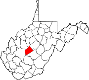
Unincorporated
communitiesAdonijah | Bentree‡ | Bickmore | Big Otter | Bomont | Dille | Duck | Floe | Fola | Glen | Harrison | Independence | Indore | Ivydale | Little Italy | Lizemores | Maysel | Nebo | O'Brion | Ovapa | Porter | Procious | Swandale | Valley Fork | Wallback‡ | Whetstone | Widen
Footnotes ‡This populated place also has portions in an adjacent county or counties
Categories:- Populated places in Clay County, West Virginia
- Unincorporated communities in West Virginia
- Mountain Lakes geography stubs


Wikimedia Foundation. 2010.