- Dobrovo
-
Dobrovo Dobrovo Castle Location in Slovenia Coordinates: 45°59′56.14″N 13°31′46.6″E / 45.9989278°N 13.529611°ECoordinates: 45°59′56.14″N 13°31′46.6″E / 45.9989278°N 13.529611°E Country  Slovenia
Region Slovenian Littoral Municipality Brda Area – Total 1.16 km2 (0.4 sq mi) Elevation 122.7 m (403 ft) Population (2002) – Total 413 [1] Dobrovo (Italianized: Castel Dobra) is a settlement the Littoral region of Slovenia, close to the border with Italy. It is the administrative centre of the Brda Municipality.[2] It lies on the road that connects the Friuli Plain and the Soča Valley.
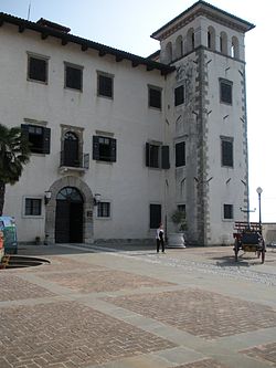
Dobrovo Castle is a castle in the settlement built around 1600 on the foundations of an older structure. It is an almost perfect square in plan with square turrets on each corner. It houses an art gallery and a museum.[3] The castle chapel is dedicated to Saint Anthony of Padua and belongs to the Biljana Parish.[4]
References
External links
Brda Settlements Administrative centre: Dobrovo
Barbana, Belo, Biljana, Brdice pri Kožbani, Brdice pri Neblem, Breg pri Golem Brdu, Brestje, Brezovk, Ceglo, Dolnje Cerovo, Drnovk, Fojana, Golo Brdo, Gonjače, Gornje Cerovo, Gradno, Hlevnik, Hruševlje, Hum, Imenje, Kojsko, Kozana, Kozarno, Kožbana, Krasno, Medana, Neblo, Nozno, Plešivo, Podsabotin, Pristavo, Senik, Slapnik, Slavče, Snežatno, Snežeče, Šlovrenc, Šmartno, Vedrijan, Vipolže, Višnjevik, Vrhovlje pri Kojskem, Vrhovlje pri Kožbani, Zali BregLandmarks Dobrovo Castle, Vipolže CastleNotable people Alojz Gradnik, Zoran Mušič, Ludvik ZorzutCategories:- Populated places in the Municipality of Brda
- Goriška statistical region geography stubs
Wikimedia Foundation. 2010.


