- Čitluk
Infobox Settlement
official_name = PAGENAME
settlement_type =
subdivision_type = Country
subdivision_name = BIH
timezone=CET
utc_offset=+1
map_caption =Location of PAGENAME within Bosnia and Herzegovina.
timezone_DST=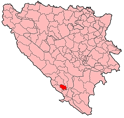
leader_name =Ivo Jerkić (HDZ)|area_total_km2 = 181
population_total = 14709|population_footnotes=
population_as_of=1991 census
population_density_km2 =
pushpin_
pushpin_label_position =
pushpin_map_caption =Location of Čitluk
pushpin_mapsize =
latd =
latm=
longd=
longm=
area_code = +387 36
parts =
website = http://www.citluk.baČitluk is a town located in southern
Herzegovina ,Bosnia and Herzegovina . It is a municipality of theHerzegovina-Neretva Canton in theFederation of Bosnia and Herzegovina .The municipality is home to the world famous Marian Shrine of
Međugorje which is located just to the south of the town of Čitluk.Population/Demographics
1971
15.359 total
* Croats - 15.055 (98,02%)
* Muslims - 183 (1,19%)
* Serbs - 64 (0,41%)
* Yugoslavs - 0
* others - 57 (0,38%)1991
In
1991 , the municipality had a population of 14,709, of which there were 14,544Croats (98.9%), 110Bosniaks (0.8%), 19Serbs (0.1%), 17Yugoslavs (0.1%) and 19 others (0.1%). The town of Čitluk had 4,317 residents: with 99% of those beingCroats .ports
The town is home to the football club
NK Brotnjo , and thebasketball club HKK Brotnjo.External links
* [http://www.citluk.ba/ Municipality of Čitluk] hr icon
* [http://www.dugatehna.ba Duga-Tehna]
* [http://www.lan-wars.com/ Lan-Wars ]
* [http://www.etico.ba/ Etico d.o.o ]

Wikimedia Foundation. 2010.