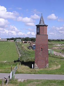
- Dagebüll lighthouse
-
Dagebüll 
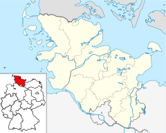
Location Dagebüll, Nordfriesland district, Germany Coordinates 54°43′31″N 8°41′59.5″E / 54.72528°N 8.699861°ECoordinates: 54°43′31″N 8°41′59.5″E / 54.72528°N 8.699861°E Year first constructed 1929 Deactivated 1988 Foundation 36 wooden poles. Construction Bricks Tower shape Square tower with octagonal lantern Markings / pattern Unpainted brick tower with black and green pitched roof. Height 15.20 metres (50 ft) Focal height 10.30 metres (34 ft) Range 17 nautical miles (31 km; 20 mi) Characteristic ISO 4 s ARLHS number FED-068 Dagebüll lighthouse is a retired lighthouse in Dagebüll, Nordfriesland, Germany. Until its replacement in 1988 by a direction light on the dock of the Dagebüll ferry port, it served as the lower light of the Dagebüll range of leading lights. The lighthouse is situated in the southern part of the municipality near the depot of the lorry rail to islands of Oland and Langeneß. After an additional storey had be added to the tower due to a raise of the sea dike in 1980, the tower is now 12.5 m tall. It's focal height is at 10.3 m above the highest high tide. Especially notable is the pitched roof, a black and green copper construction.
References
- Rowlett, Russ. "Lighthouses of Germany: Cuxhaven to Sylt". The Lighthouse Directory. University of North Carolina at Chapel Hill. http://www.unc.edu/~rowlett/lighthouse/deu2b.htm.
- "Die schönsten Leuchttürme Norddeutschlands: Dagebüll (Nordsee)" (in German). Norddeutscher Rundfunk. http://www3.ndr.de/sendungen/hitlisten_des_nordens/hitlistenabstimmung102.html?mode=item&IID=19443&LID=48.
- "Leuchtfeuer Dagebüll" (in German). Leuchtturm-Atlas. http://www.leuchtturm-atlas.de/HTML/DagebXT.html.
Categories:- Lighthouses in Schleswig-Holstein
- Lighthouse stubs
- Schleswig-Holstein geography stubs
- German building and structure stubs
Wikimedia Foundation. 2010.

