- Cuan Sound
-
 Cuan Sound
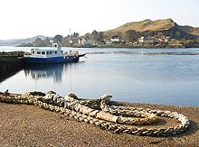
Cuan Sound is a narrow channel, 200 metres (660 ft) wide, in Argyllshire, western Scotland. It separates Seil Island and Luing and later becomes the Firth of Lorn. It has a very strong current.[1] The Cuan Ferry service crosses the sound.[2] In Cuan Sound, the north-going stream begins 4.5 hours after high water and sets westward; the south-going stream begins 1.5 hours before high water and sets eastward; the streams attain a rate of 7 knots at springs. This coast from Cuan Sound to Easdale Bay is in many places foul and rocky for 1.5 cables of it. Sgeir na Faoileann, a rock above water, one cable from the shore, and 3.5 cables northward of the entrance to Cuan Sound, is surrounded by foul ground, which extends 1.5 cables south-westward from it.[3] Coirebhreacain and Cuan Sound are seldom attempted except near slack water.[4]
References
- ^ Bartholomew, John George (1904). The survey gazetteer of the British Isles, topographical, statistical, and commercial: compiled from the 1901 census and the latest official returns (Public domain ed.). G. Newnes, limited. pp. 209–. http://books.google.com/books?id=kSYOAQAAMAAJ&pg=PA209. Retrieved 29 October 2011.
- ^ "Luing". Undiscovered Scotland. http://www.undiscoveredscotland.co.uk/luing/luing. Retrieved 2007-07-28.
- ^ Great Britain. Hydrographic Dept (1911). West Coast of Scotland Pilot (Public domain ed.). Printed for the Hydrographic Department, Admiralty by Taylor, Garnett, Evans, & Co.. pp. 157–. http://books.google.com/books?id=eMFBAAAAIAAJ&pg=PA157. Retrieved 29 October 2011.
- ^ U.S. Coast and Geodetic Survey (1907). Report of the Superintendent ... showing the progress of the work (Public domain ed.). Govt. print. off.. pp. 350–. http://books.google.com/books?id=S3HpAAAAMAAJ&pg=PA350. Retrieved 29 October 2011.
Coordinates: 56°16′5.66″N 5°37′45.38″W / 56.2682389°N 5.6292722°WCategories:- Argyll and Bute geography stubs
- Sounds of Scotland

Wikimedia Foundation. 2010.