- Creal Reef Light
-
Creal Reef Light 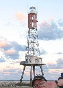

Location Mackay, Queensland, Australia Coordinates 20°32′02.3″S 150°22′49.84″E / 20.533972°S 150.3805111°ECoordinates: 20°32′02.3″S 150°22′49.84″E / 20.533972°S 150.3805111°E Year first constructed 1985 Foundation reinforced concrete hut on four piles Construction stainless steel skeletal Tower shape square Markings / pattern white lantern Height 34.5 metres (113 ft) Focal height 32 metres (105 ft) Current lens VRB-25 Intensity 104,000 cd Characteristic Fl.W. 7.5s Racon M Admiralty number K3052 NGA number 111-10229 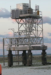 the weather station on Creal Reef
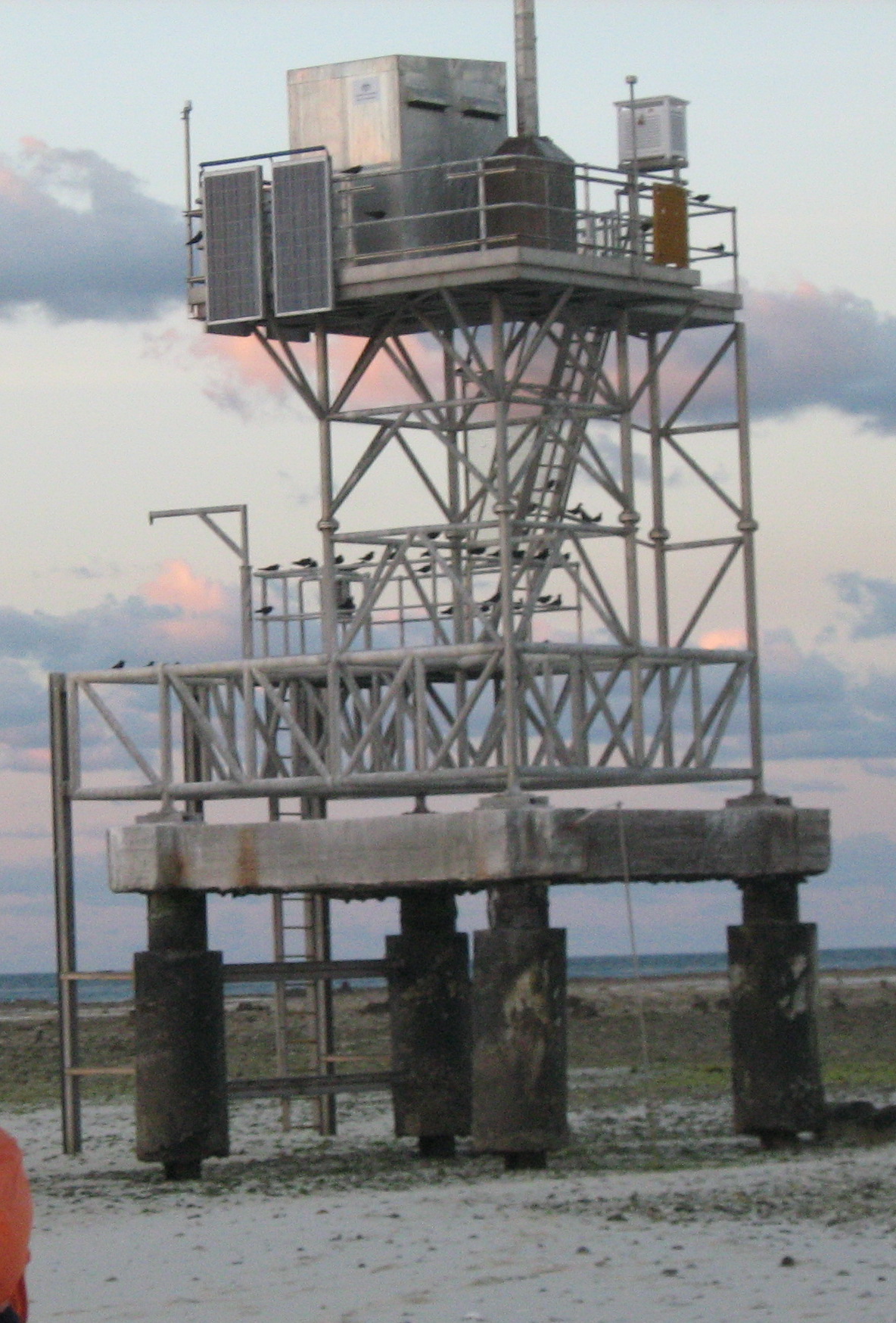
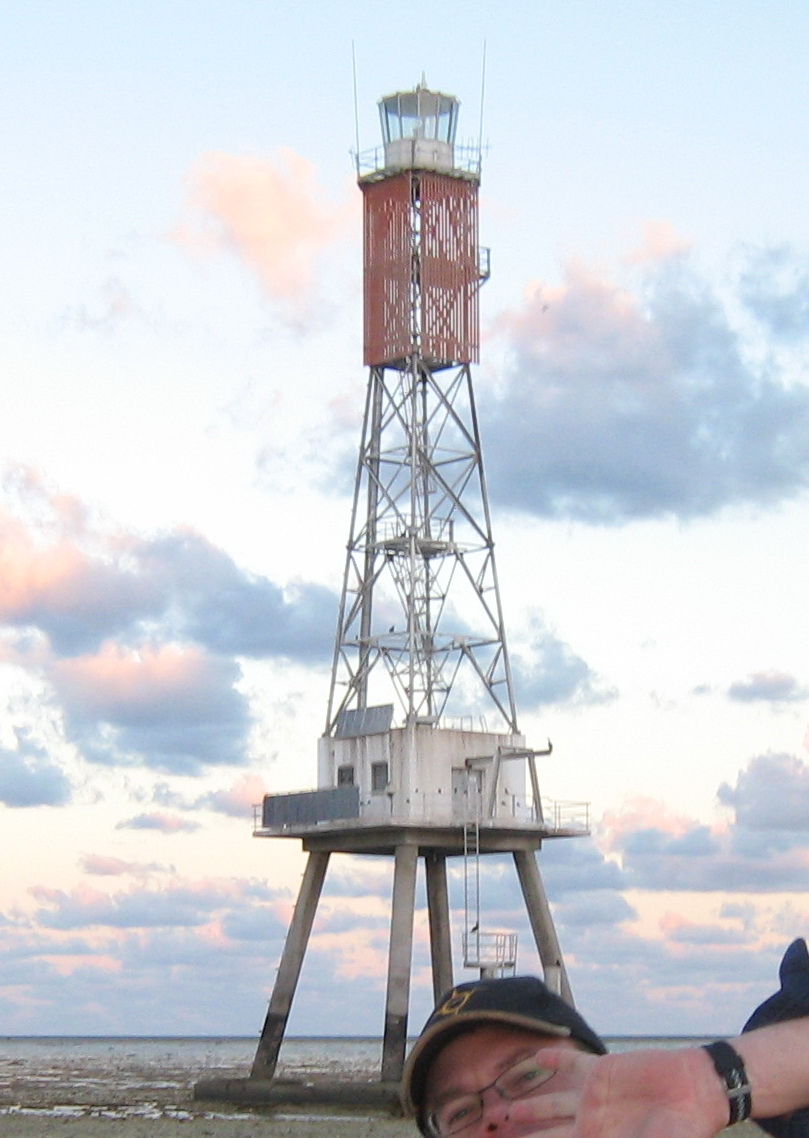
Creal Reef Light is an active lighthouse located at Creal Reef, a planar reef about 150 kilometres (93 mi) east of Mackay, Queensland, Australia. It guides ships outgoing from Mackay into Hydrographers Passage, a deep water channel east of Mackay.[1] The structure is a stainless steel tower, which also serves as a daymark and carries a racon.
Contents
Creal Reef
Creal Reef is a middle shelf planar reef with an area of 1.6 square kilometres (0.62 sq mi).[2] It was named in the late 1920s by Captain John A. Edgell (RN) on the survey ship HMAS Moresby, during the Moresby survey of the Cumberland Channel inside the Great Barrier Reef.[3] It was named after Denis A. J. Creal, a pilot with the No. 101 Flight RAAF who assisted the Moresby with her surveys.[4]
Structure and display
The structure, established in April 1985, is a 21 metres (69 ft) stainless steel skeletal tower with a white lantern, standing on a reinforced concrete hut, supported on four piles. The total height from the ground to the top platform is 34.5 metres (113 ft).[5] The light shares the location with an automatic weather station.[6]
The current light characteristic is a white flash every 7.5 seconds (Fl.W. 7.5s) visible for a distance of 19 nautical miles (35 km; 22 mi).[7] The apparatus is a solar powered VRB-25 rotating at 1.33 rpm. The light source is a 12 Volt 75 Watt Halogen lamp with an intensity of 104,000 cd.[5] The racon, mounted at an elevation of 34 metres (112 ft),[8] transmits a morse code "M" (- -) for a distance of 16 nautical miles (30 km; 18 mi).[9]
The daymark, displayed at 33 metres (108 ft) above MHWS, comprises two orange 3 by 7 metres (9.8 × 23 ft) slats on the northern and western faces.[5]
Site operation and visiting
The site and the tower are operated by the Australian Maritime Safety Authority.[5] The island is accessible only by boat, and both the site and the tower are closed to the public.[1]
See also
- List of lighthouses and lightvessels in Australia
References
- ^ a b Rowlett, Russ. "Lighthouses of Australia: Queensland's East Coast". The Lighthouse Directory. University of North Carolina at Chapel Hill. http://www.unc.edu/~rowlett/lighthouse/qld.htm. Retrieved 2010-11-14.
- ^ "AIMS Research - Reef Monitoring". data.aims.gov.au. http://data.aims.gov.au/reefpage2/reefpage.jsp?fullReefID=20297S. Retrieved 22 February 2011.
- ^ "HMAS Moresby (I)". Sea Power Centre Australia. http://www.navy.gov.au/HMAS_Moresby_(I). Retrieved 15 September 2008.
- ^ Ray Blackwood (1997). The Whitsunday Islands - An Historical Dictionary. p. 55. quoted in "Street Names of Mackay , Queensland, Australia". mackayhistory.org. Mackay Historical Society. 2010. http://www.mackayhistory.org/research/street_names/street_names.html. Retrieved 22 February 2011.
- ^ a b c d "Creal Reef Light, QLD, AN424-01". Aids to Navigation Schedule Issue 10. Australian Maritime Safety Authority. December 2006. http://www.amsa.gov.au/drawingregister/drawings/ans/AN424-01.pdf.
- ^ Michael Pitcher (September/October 2006). "The Lighting of Hydrographers Passage – Part 2". Lighthouses of Australia Inc. Bulletin 9 (5). http://www.lighthouse.net.au/lights/Bulletin/0609/hydrographers_part2.htm.
- ^ List of Light. Note that AN424-1 lists visibility distance of 16 nautical miles (30 km; 18 mi), but the date is 2006.
- ^ "Creal Reef Racon, QLD, AN424-04". Aids to Navigation Schedule Issue 10. Australian Maritime Safety Authority. December 2006. http://www.amsa.gov.au/drawingregister/drawings/ans/AN424-04.pdf.
- ^ (PDF) List of Lights, Pub. 111, The West Coasts of North and South America (Excluding Continental U.S.A. and Hawaii), Australia, Tasmania, New Zealand, and the Islands of the North and South Pacific Oceans. List of Lights. United States National Geospatial-Intelligence Agency. 2010. p. 203. http://msi.nga.mil/MSISiteContent/StaticFiles/NAV_PUBS/NIMA_LOL/Pub111/Pub111bk.pdf.
External links
- "List of Lighthouses of Queensland". Lighthouses of Australia. Lighthouses of Australia Inc. http://www.lighthouse.net.au/lights/QLD/Index%20QLD.asp.
- Searle, Garry. "List of Lighthouses - Queensland". Lighthouses of Australia. SeaSide Lights. http://www.seasidelights.com.au/state.asp?fState=QLD.
Lighthouses of Queensland South East Coast Point Danger • Cleveland Point • Moreton Bay Pile • Bulwer Island • Old Caloundra • New Caloundra • Point Cartwright • Double Island Point
Central Coast Sandy Cape • Lady Elliot Island • Old Burnett Heads • New Burnett Heads • Bustard Head • North Reef • Sea Hill • Cape CapricornNorth Coast Flat Top Island • Pine Islet • Creal Reef • Dent Island • Cape Bowling Green • Cape Cleveland • Bay RockFar North Coast Fitzroy Island • Low Isles • Grassy Hill • Archer Point • Wharton ReefTorres Strait Wyborn Reef • Eborac Island • Goods Island • Booby IslandSee also: List of lighthouses and lightvessels in AustraliaCategories:- Buildings and structures completed in 1985
- Lighthouses in Queensland

Wikimedia Foundation. 2010.