- Church of St Mary, Marston Magna
-
Church of St Mary 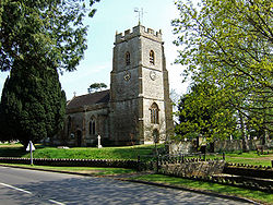
Location: Marston Magna, Somerset, England Coordinates: 50°59′55″N 2°34′46″W / 50.99861°N 2.57944°WCoordinates: 50°59′55″N 2°34′46″W / 50.99861°N 2.57944°W Built: c. 1360 Listed Building – Grade I Designated: 19 April, 1961[1] Reference #: 262672 
 Location of Church of St Mary in Somerset
The Church of St Mary in Marston Magna, Somerset, England can date its origins to before the Norman Conquest, however the present building largely dates from around 1360,[2] with further rebuilding in the 15th century. It has been designated as a grade I listed building.[1]
The church was held by Polsloe Priory, near Exeter from the 12th century until the dissolution of the monasteries.[3]
There are two small windows heads on each side of the central arch which remain from the Saxon church which once stood on the site, and the north wall, which includes herringbone masonry, and the font are Norman.[2] The triple lancet east window dates from around 1230, although the glass is Victorian. The Lady Chapel is from the 15th century, as is the oak screen below the west gallery and rood screen.[2]
The three stage tower has a stair turret on the south east corner leading to the belfry, which is surmounted by battlements, crocheted pinnacles and gargoyles. The vestry in the base of the tower includes a clock by William Monk, who also made the clock in Sherborne Abbey, and dating from 1710. The bells were dedicated in 1912 when new land was added to the churchyard at the expense of the governors of Winchester College.[2]
See also
- List of Grade I listed buildings in South Somerset
- List of towers in Somerset
References
- ^ a b "Church of St Mary". Images of England. English Heritage. http://www.imagesofengland.org.uk/Details/Default.aspx?id=262672. Retrieved 2009-01-25.
- ^ a b c d Robinson, W.J. (1915). West Country Churches. Bristol: Bristol Times and Mirror Ltd. pp. 43–47.
- ^ Bush, Robin (1994). Somerset: The complete guide. Wimborne: The Dovecote Press Ltd. pp. 137. ISBN 1874336261.
Categories:- Church of England churches in Somerset
- 14th-century architecture
- Grade I listed churches
- Grade I listed buildings in Somerset
- South Somerset


Wikimedia Foundation. 2010.