Church of St Mary, Bishops Lydeard

Church of St Mary, Bishops Lydeard
Church of St Mary
Red stone building with square tower. In the foreground is a graveyard.
Church of St Mary, Bishops Lydeard is located in Somerset
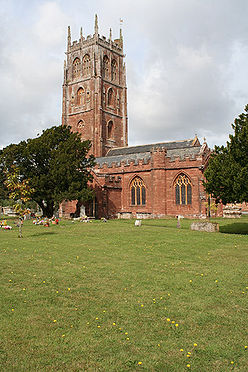
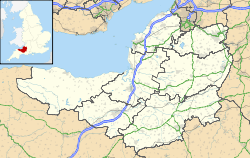
Location within Somerset
General information
Town or city Bishops Lydeard
Country England
Coordinates 51°03′41″N 3°11′14″W / 51.0614°N 3.1872°W / 51.0614; -3.1872
Completed 14th century

The Church of St Maryin Bishops Lydeard, Somerset, England dates from the 14th and 15th centuries and has been designated as a Grade I listed building.[1]

In 1860–62 the church was extended by one bay and a vestry, by Edward Jeboult of Taunton, added.

The tower, which was built around 1497,[2] has pierced tracery battlements, pinnacles, set back buttresses terminating in pinnacles at the bell-storey, and pinnacles on the buttresses at each stage.[1]

Several of the tombs in the churchyard are of historical importance, as are two crosses, one dating from the 14th century,[3] the other being the town's market cross which was moved to the churchyard in the 19th century.[4]

See also

References

  1. ^ a b "Church of St Mary". Images of England. http://www.imagesofengland.org.uk/details/default.aspx?id=270227. Retrieved 2007-02-09. 
  2. ^ Poyntz Wright, Peter (1981). The Parish Church Towers of Somerset, Their construction, craftsmanship and chronology 1350 - 1550. Avebury Publishing Company. ISBN 0861275020. 
  3. ^ "Cross in Churchyard, Church of St Mary". Images of England. http://www.imagesofengland.org.uk/details/default.aspx?id=270228. Retrieved 2007-02-09. 
  4. ^ Adkins, Lesley and Roy (1992). A Field Guide to Somerset Archaeology. Wimborne, Dorset: Dovecote Press. ISBN 0946159947. 

Wikimedia Foundation. 2010.

Игры ⚽ Поможем решить контрольную работу

Look at other dictionaries:

  • Bishops Lydeard — infobox UK place country = England latitude= 51.06150 longitude= 3.18720 official name= Bishops Lydeard population =3,949 shire district= Taunton Deane shire county = Somerset region= South West England constituency westminster= post town=… …   Wikipedia

  • St. Mary's Church — Contents 1 Albania 2 Azerbaijan 3 Belarus 4 Bosnia and …   Wikipedia

  • List of Grade I listed buildings in Somerset — There are over 6000 Grade I listed buildings in England. This page is a list of these buildings in the county of Somerset.Bath North East Somerset* Abbey Church, Bath (Grade A) * Abbey Church Yard, Bath: No 14 * Grand Pump Room, Bath * Grand Pump …   Wikipedia

  • List of towers in Somerset — The Somerset Towers, built in the 14th to 16th centuries, have been describe as among England s finest contributions to medieval art.cite book |last= Jenkins|first=Simon|title= England s Thousand Best Churches|year= 2000|publisher= Penguin… …   Wikipedia

  • Quantock Hills — Geobox Protected Area name =Quantock Hills native name = other name = other name1 = category local =Area of Outstanding Natural Beauty category iucn = image size = image caption = Upland scrub in the Quantocks etymology = country = England… …   Wikipedia

  • Cothelstone — Coordinates: 51°04′37″N 3°09′53″W / 51.0770°N 3.1647°W / 51.0770; 3.1647 …   Wikipedia

  • Cotford St Luke — Coordinates: 51°02′21″N 3°11′19″W / 51.0392°N 3.1886°W / 51.0392; 3.1886 …   Wikipedia

  • North Curry — Coordinates: 51°01′29″N 2°57′50″W / 51.0248°N 2.9638°W / 51.0248; 2.9638 …   Wikipedia

  • Chipstable — Coordinates: 51°02′09″N 3°21′58″W / 51.0357°N 3.3660°W / 51.0357; 3.3660 …   Wikipedia

  • Orchard Portman — Coordinates: 50°59′16″N 3°04′37″W / 50.9879°N 3.0770°W / 50.9879; 3.0770 …   Wikipedia

Share the article and excerpts

Direct link
Do a right-click on the link above
and select “Copy Link”