- Church of St James, Curry Mallet
-
Church of St James 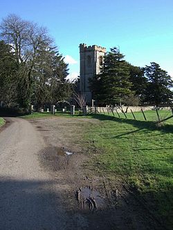
Location: Curry Mallet, Somerset, England Coordinates: 50°59′01″N 2°56′59″W / 50.98361°N 2.94972°WCoordinates: 50°59′01″N 2°56′59″W / 50.98361°N 2.94972°W Built: 13th century Listed Building – Grade I Designated: 17 April 1959[1] Reference #: 431242 
 Location of Church of St James in Somerset
The Church of St James in Curry Mallet, Somerset, England has 13th-century origins and has been designated as a Grade I listed building.[1]
The church is dedicated to All Saints,[2] It has a three stage tower. Inside the church is a 15th century font.[1]
The parish is part of the Seven Sowers benefice which covers Curry Mallet, Hatch Beauchamp, Orchard Portman, Staple Fitzpaine, Stoke St Mary (with Thurlbear) and West Hatch, within the deanery of Crewkerne and Ilminster.[3][4]
See also
- List of Grade I listed buildings in South Somerset
- List of towers in Somerset
References
- ^ a b c "Church of St James". Images of England. English Heritage. http://www.imagesofengland.org.uk/Details/Default.aspx?id=431242. Retrieved 12 October 2008.
- ^ "Curry Mallet Neighbourhood Plan". Yarlington Housing Group. http://www.yhg.co.uk/Libraries/Neighbourhood_Plans/Curry_Mallett_Neighbourhood_Plan.sflb.ashx. Retrieved 22 September 2011.
- ^ "All Saints Church, Curry Mallet". Church of England. http://www.achurchnearyou.com/curry-mallet-church/. Retrieved 22 September 2011.
- ^ "Curry Mallett". Seven Sowers Benefice. Church of England. http://www.sevensowers.org.uk/the-churches/curry-mallet/. Retrieved 22 September 2011.
Categories:- Church of England churches in Somerset
- 13th-century architecture
- Grade I listed churches
- Grade I listed buildings in Somerset
- South Somerset


Wikimedia Foundation. 2010.