- Christchurch Railway Cycleway
-
Christchurch Railway Cycleway 
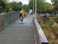
Pathway south of Wairakei Road Length 6 km Location Christchurch, New Zealand Trailheads Kilmarnock Street (south) / Tuckers Road (north) Use Walking
CyclingElevation Gain/Loss nil Trail difficulty Easy Season Year round The Christchurch Railway Cycleway follows the Main North railway in Christchurch. The route currently extends from Kilmarnock Street in Riccarton in the south to Northcote Road in Northcote, Christchurch. The immediate section to the north, up to Tuckers Road, is currently (early 2010) under construction. When this section is finished, the pathway will be about 6 km long.
Contents
Route
Existing path
The path follows the route of the Main North Line, which is operational. A description of the route can be found in a Christchurch City Council publication.[1]
Proposed path extension
A pathway extension to the north (from Tuckers Road to Main North Road) is under design. A feasibility study commissioned by Christchurch City Council has covered an extension to the suburb of Belfast.
Intersection control
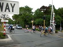
The core section of the pathway (from Harewood Road to Matai Street (was constructed in the late 1990s / early 2000s. Of the five road crossings, three (Fendalton Road, Wairakei Road and Glandovey Road) were considered to require traffic signal control.[2] One of the crossing points (Blighs Road) has since been retrofitted with traffic signals.
References
- ^ http://www.ccc.govt.nz/cycling/CycleMaps/08PapanuiToCity.pdf Map and route description
- ^ http://viastrada.co.nz/sites/viastrada/files/lloyd-2000.pdf Conference paper on technical aspects of the project
External links
Categories:- Transport in Christchurch
- Rail trails in New Zealand
Wikimedia Foundation. 2010.

