- Choazil Islands
-
 Map
Map
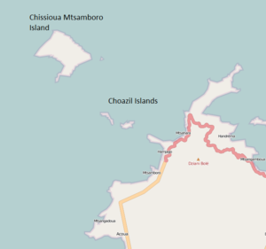
The Choazil Islands, also known as the Malandzamia Islands, are two small islands located off the shore of Mtsamboro, northern Mayotte in the Indian Ocean. To the northwest is the larger Chissioua Mtsamboro (widely known as Zamburu Island). This stretch of water is known as the Choazil Passage, part of the Mozambique Channel.
Coral reefs border all sides of the island except the southern.[1] The western of the Choazil Islands is said to be 164 feet high. [1]The soundings close to the reef surrounding Zamburu are reportedly from 10 to 15 fathoms.[2]
References
- ^ a b United States. Hydrographic Office (1 January 1952). Publications. p. 157. http://books.google.com/books?id=D3IPAQAAIAAJ. Retrieved 15 June 2011.
- ^ Rosser, William Henry; Imray, James Frederick (1867). The seaman's guide to the navigation of the Indian Ocean and China Sea: including a description of the wind, storms, tides, currents, &c., sailing directions; a full account of all the islands; with notes on making passages during the different seasons. J. Imray & Son. p. 364. http://books.google.com/books?id=_8BBAAAAIAAJ&pg=PA364. Retrieved 15 June 2011.
Categories:- Islands of Mayotte
- Mayotte geography stubs

Wikimedia Foundation. 2010.