- Chiselbury
-
Chiselbury 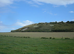
Chiselbury 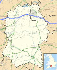
 Shown within Wiltshire
Location Wiltshire Coordinates 51°03′08″N 1°58′33″W / 51.0522°N 1.9757°W Area 10.5 acres History Periods Iron Age Site notes Public access yes Chiselbury is the site of an Iron Age univallate hillfort located in Wiltshire. The hillfort is sub-circular in plan, and encloses an area of approximately 10.5 acres. It is defined by an earthen rampart up to 3.6m in height and an external ditch, up to a maximum of 1.6m in depth. A gap in the southeastern side of the rampart, and a corresponding causeway across the ditch, is thought to be the original entrance and is associated with a small 'D' shaped embanked enclosure, which is apparently visible on aerial photographs. Although the enclosure has subsequently been degraded by ploughing, it is still apparent as a series of low earthworks.[1]
Limited archaeological investigation of the interior of the hillfort in the early 20th century[2] failed to find any direct traces of occupation. However, outside of the fort some Iron Age pottery and a lead spindle whorl were found. In addition, two Roman coins, one of which dated to the reign of Emperor Constantine I, were said to have been found within the central area. An Iron Age sword and scabbard were also found on the nearby trackway which runs along the ridge top.[1]
The hillfort is abutted on both its northern and southern sides by embanked ditches or cross dykes. Their precise function is unknown but the manner in which they cut the ridge suggests that they were intended to prevent movement along it. The northern cross dyke, 90m in length, ran from the ditch of the hillfort across the top of the ridge before continuing part way down its northern slopes. Although visible in 1928, the section between the hillfort and the edge of the ridge has subsequently been infilled by ploughing, but survives as a buried feature. The southern cross dyke, which survives as a discontinuous series of banks and ditches, (sections of which are filled in but survive as buried features) is a total of 180m in length. It travels roughly south-southeast from the 'D' shaped enclosure, down the southern slope of the ridge, and into the base of a valley.[1]
An aerial photograph from 1928 clearly shows the southern cross dyke continuing as a buried feature beneath a trackway which runs along the ridge top, indicating that the trackway came into use after the cross dyke was constructed. An Anglo-Saxon charter also mentions 'the ridgeway' suggesting that the trackway was in use by at least the early medieval period. Referred to as the 'Ten Mile Course' by Dr Stukeley in 1776, in the medieval and postmedieval periods the trackway was the main route from Wilton to Shaftesbury. By the 18th century it had become a turnpike road, and a map dated to 1773 depicts a toll house immediately to the south of it. The remains of the former toll house structure are visible today as a series of earthworks representing a building platform with a small enclosure immediately to its east.[1]
The site is a scheduled national monument no.33966
Today, the site is also famous for the Fovant Badges, which are a number of regimental badges cut into the chalk of the hill on its northern flank. These were created by soldiers garrisoned near Fovant during the First World War, and are clearly visible from the A30 which runs through the village
Location
The site is located at grid reference SU018281, to the southeasst of the small village of Fovant, in the county of Wiltshire. The hill has a summit of 201m AOD. There are public footpaths and bridleways to the east and south of the site.
References
- ^ a b c d "Extract from English Heritage's Record of Scheduled Monuments: Chiselbury Camp hillfort, cross dykes and site of turnpike toll house". http://www.magic.gov.uk/rsm/33966.pdf. Retrieved 11 October 2010.
- ^ The Ancient History of Wiltshire, by Sir Richard Colt Hoare, published 1812, Chapter No. 11 - Station 8: Fovant
See also
Categories:- Iron Age sites in England
- Buildings and structures in Wiltshire
- Hill forts in Wiltshire
- Archaeological sites in Wiltshire


Wikimedia Foundation. 2010.